SITE CONTENT
Antique Maps & Prints
Britain
Antique Maps - World
Antique Books
Cartographers
Early Prints
Other Stock
|
| Maps of the West Indies |
Images |
(Code No. 6813)
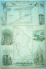
Tallis, John & John Rapkin.
(Antique Map).
British Guayana.
Date. (c.1850).
London & New York, J.Tallis. Page size [14 x 10 1/2ins]. Original steel engraved map with outline hand-colouring. Drawn and engraved by John Rapkin. Centre fold. Showing: - Vignette scenes of New Amsterdam, Ataraipu' or Devil's Rock, Christmas Cataract on the River Berbice, and Georgrtown by H. Winkles. very good condition....... £45.00 |
Click on picture above to view more images
How to order |
(Code No. 6534)
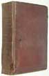
Williams, Gomer.
History of the Liverpool privateers and letters of marque with an account of the Liverpool slave trade.
Date. 1897.
London: Heinemann. 8vo, [6 x 9ins]. Pp. xv, 718 + 4 Folding facsimile prints. Owner's book plate on front past down. Original cloth covers, faded and shaken. Spine cloth poor. Holding firm..
Slavery in British colonies was finally abolished in 1833 and slave trading was made illegal in 1807 though some slavery apprenticeships ran until 1838. Many factors led to the demise of slavery including revolts, piracy, social unrest, and the repercussions of corruption such as slave insurance fraud, e.g. the Zong massacre case in 1783. It was Liverpool born politician William Roscoe who spearheaded the anti-Slavery movement in parliament at the time...... £80.00 |
Click on picture above to view more images
How to order |
(Code No. 5705)
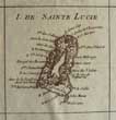
Bonne, Rigobert.
(Antique Map showing 10 inset maps on one page)
Supplement Pour Les Isles Antilles Extrait Des Cartes Angloises.
Date. 1780.
Paris, Bonne. Page size, (approx), [16 x 10 1/2ins]. Image size [8 1/2 x 12 1/2 ins.] Original Copper engraved map of Barboude, St. Christopher, Antiqua, Dominica, St. Lucie, Barbadoes, St. Vincent, Grenada & Tobago & Isles Vierges (Virgin Islands), slight browing..... £70.00 |
Click on picture above to view more images
How to order |
(Code No. 5211)Lodge. J.(Antique map.)AN ACCURATE MAP OF THE ISLAND OF ST. CHRISTOPHERS, from an Actual Survey; shewing the Parishes, Churches and Rivers......Date. Feb 1782.London. Bew. Map image size 14 1/2 x 10 3/4 ins. Copper engraved map by J Lodge, slight split into borderline and some off setting. Compass rose, sounding, anchorages. Scale line, 7 /12 inches to the mile. A detailed map showing forts and churches etc.
|
SOLD.
|
(Code No. 4807)
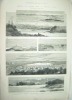
Pilleau, Major.
( Antique Print.)
Bermuda, The Winter Home of Princess Louise.
Date. Feb, 17th, 1883.
London. Illustrated London News, Page size 11 x 16ins.Original engraved woodcut print by Montbard. From a sketch by Major Pilleau, creasing to outer margin not affecting engraved area.
Showing Hamilton Harbour, Hungary Bay, Signal Station, St George, Fort Catherine, St George Sound and Head of Hamilton Harbour. £45.00
|
Click on picture above to view more images
How to order |
(Code No. 4570)
Bellin, Jacques Nicolas. (1703-1772).
(Antique Chart of Jamaica)
Carte de L'Isle la Jamaique Par le S. Bellin Ingen; de la Marine 1758.
Date. [c.1769]
Paris. Image size 8 X 12ins. Page size 14 x 10ins. Original hand-coloured copper engraved chart, very good condition. Shows, parishes, harbors, roads , mountains, rivers, etc.
Jacques-Nicolas Bellin was a French hydrographer and cartographer. He was born in Paris. In 1721 Bellin was appointed hydrographer (chief cartographer) to the French Navy upon the creation of France's hydrographic office, the Dépôt des cartes et plans de la Marine. Appointed "ingénieur hydrographe" in August 1741. Member of the Académie de Marine and of the Royal Society of London. Over a 50 year career, he produced a large number of maps of particular interest to the Ministère de la Marine. His maps of Canada and of French territories in North America (New France, Acadia, Louisiana) are particularly valuable..... £90.00. |
Click on picture above to view more images
How to order |
(Code No. 4543)Homann. Heirs.(Antique map of the Island of Barbados.)INSULA BARBADOES IN SUAS PAROCHIAS DISTINCTA, UNA CUM ORIS MARITIMIS, VUS & AD FIDEM ANGLICANI AUTHORIS DELINEATADate. 1720.Image size 10 3/4 x 8 3/4ins. Original copper engraved map, borders trimmed to neatline, (as issued), with original outline hand colour. Very good condition.
|
SOLD.
|
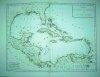
(Code No. 4538)(Antique Map of the West Indies.)Moll, Herman.A map of the West-Indies &c., Mexico or New Spain. Also ye trade winds, and ye several tracts made by ye Galeons and Flota from place to place. By H. Moll Geographer.Date. [c1736?].London: Thos. Bowles and John Bowles. Image size 10 x 7 3/4ins. Original hand coloured copper engraved map, slight nick into engraved border, (no loss). Taken from the atlas- "Atlas minor: or a new and curious set of sixty-two maps"
|
SOLD.
|
(Code No. 4535)
MENTELLE, Edme & P. F. Tardieu.
(Antique Map of the West Indies.)
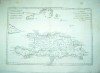
Carte du Golfe du Mexique et des Isles Antilles.
Date. 1782.
Paris, Image size 17 x 12 1/2ins. Page size 22 x 15ins. Original outline hand-colour, ( very pale), copper engraved map, The whole of the West Indies and the coast from Florida to Venezuela. Mapmaker:
Tardieu, P[ierre] F[rancois], engraver; P. J. Valet, very fine condition. £150.00
|
Click to view more images
How to order |
(Code No. 4409)
Bonne, Rigobert .1727-1794.
( 3 Maps of the West Indies.)
Carte de L'Isle de la Martinique, Carte de L'Isle de St Domingue and Carte de L'Isle de Guadeloupe.
(Maps of the Islands of Martinique,Saint Domingue and Guadeloupe.)
Date. ca1780.
Geneva. J.L. Pellet. Page sizes, [10 1/2 x 16ins.] ca1780. 3 Copper engraved maps. Engraved by Andre, slight marks and browning.
Taken from "Atlas de Toutes les Parties Connues du Globe Terrestre" £90.00
|
Click to view more images
How to order |
(Code No. 3396)
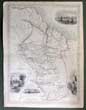
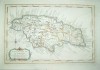
SWANSTON, G.H. & A. FULLARTON.
(Antique Map)
British Possessions on the North west Coast of South America.
London & Edinburgh. A. Fullarton & Co. Size 12 1/2 x 18 1/2 inches. ca1860. Original steel engraved map with outline hand colour by A. Swanston,two nicks to borders.
Showing two inset maps of the Islands of Trinidad and British Guayana. with vignette views of the people, natural history and a sugar mill etc. £110.00
|
Click to view more images
How to order |
(Code No. 3868)Kitchin. Thos.(Antique Map)"MAP of the EUROPEAN SETTLEMENTS in the WEST INDIES, by Thos. Kitchin, Hydrographer to His Majesty".Dublin. John Exshaw. 1784. Image size 6 x 10 1/2 ins. Page size 11 1/2 x 8 ins. Copper engraved folding map taken from Abbe Raynal's (1713-1796) "
A Philosophical and Political History of the Settlements and Trade of the Europeans in the East and West Indies" The map covers Florida to central America.
The map has a garland style title cartouche, two scale lines, (1" to 320 miles) and graduated borders, very good condition.
|
SOLD.
|
(Code No.2880)London. Bew. Feb 1782. Map
image size 14 1/2 x 10 3/4 ins. Copper engraved map by J Lodge.
Compass rose, sounding, anchorages. scale line, 1 inch to the mile.
A detailed map showing roads, fields, forts and houses etc. |
SOLD
|
(Code No. 2881) Lodge. J. (Antique map): AN
ACCURATE MAP OF THE ISLAND OF ST. CHRISTOPHERS, from an
Actual Survey; showing the Parishes, Churches and Rivers. London. Bew. [c.1790]. Map image size
14 1/2 x 10 3/4 ins. Copper engraved map by J Lodge. Compass rose, sounding and anchorages. Scale line,
7 /12 inches to the mile. A detailed map showing forts and churches
etc.
|
SOLD.
|
(Code no.2884)London. Bew. June 1782. Map image
size 9 1/2x10 3/4 ins. Copper engraved map by J Lodge.Compass
indicator,Graduated border. A detailed map showing forts and churches.
|
SOLD |
| (Code No. 3302)London, E. Stanford & Blackwood and other. No dates, ca1860-80.
Page size 24 x 27 ins (approx). 5 Original hand coloured engraved
maps by E. Stanford, (4), K. Johnston and A. Gross, vg. + (one printed
coloured map, ca1900), |
SOLD
|
Return to top
|
|