SITE CONTENT
Antique Maps & Prints
Britain
Antique Maps - World
Antique Books
Cartographers
Early Prints
Other Stock
|
| Maps,Books & Prints of North America |
Images |
(Code No. 6932)
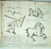
Clark, D. K./ Zerah Colburn.
( Antique Print)..
Passenger Locomotive by Paterson New Jersey U.S.A.
Date. [c.1870].
London and Glasgow William Collins, Sons, & Company. (page size approx, 29 x 22 ins) Originsl steel engraved train plate, slight water staining.
Taken from Locomotive Engineering and the Mechanism of Railways, Volume II: illustrative of The Locomotive Engine, Railway Carriages and Plant. At the death of Zerah Colburn the work was completed by D.K. Cclark..Vol. 1, text; vol. 2, plates, without author's name. Zerah Colburn (1832 – 1870) was an American engineer specialising in steam locomotive design, technical journalist and publisher..... £30.00 |

Click on picture above to view more images
How to order |
(Code No. 6812)
Tallis, John & John Rapkin.
(Antique Map).
East Canada and New Brunswick.
Date. (c.1850).
London & New York, J.Tallis. Page size [14 x 10 1/2ins]. Original steel engraved map with outline hand-colouring. Drawn and engraved by John Rapkin. Centre fold. Showing: - Large vignette scenes of Quebec, members of a native tribe. and Queen's medal. very good condition...... £45.00 |
Click on picture above to view more images
How to order |
(Code No. 6630)
Twain, Mark.
The Adventures of Huckleberry Fin.
Date. 1884, 1st UK edn.
London, Chatto and Windus. 8vo [5 1/2 x 8ins]. Pp. xvi, 438, (pp.32, adverts). Illustrated throughout.
Demand for the book spread outside of the United States. Adventures of Huckleberry Finn was eventually published on December 10, 1884, in Canada and the United Kingdom, and on February 18, 1885, in the United States.., Adventures of Huckleberry Finn has been the continued object of study by literary critics since its publication. Original decorated cloth, hinge cloth splits and fading, holding firm....... £140.00 |
Click on picture above to view more images
How to order |
(Code No. 6615)
Edgeworth, Maria.
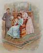
The Grateful Negro and the Birthday Present.
Date. 1883.
Edinburgh, William P. Nimmo & Co. 12mo, [4 x 6ins]. Coloured frontis. Pp 72, foxing spots & damage to front blank past down. Original decorated cloth, spine faded.
In Jamaica two plantation owners, whose methods of managing their slaves were as different as possible. Mr. Jefferies considered the Negroes as an inferior species, he treated his slaves, or rather suffered his overseer to treat them, with the greatest severity. On the contrary the slave owner Mr. Edwards treated his slaves with far more consideration. He was more understanding and treated them with dignity and kindness.
........ £50.00 |

Click on picture above to view more images
How to order |
(Code No. 6571)HUGHES, E & others.History of the Welsh in Minnesota, Foreston and Lime Springs, Ia.Gathered by the old settlers.Date. 1895.[Free Press Printing Co.: Mankato, Minnesota].. 8vo, [6 1/4 x 9 1/2ins].. Pp. 306 [1]. Illustrated throughout. Edited by Revs. Thos. E. Hughes, David Edwards, Messrs. Hugh G. Roberts and Thomas Hughes. Original cloth gilt, slight marks & fading......
|
SOLD.
|
(Code No. 6520)
SEMMES, Admiral Raphael.
Service Afloat;
The Remarkable Career of the Confederate Cruisers Sumter and Alabama, during the War Between the States.
Date. (c.1887).
[Baltimore Publishing Co]. 8vo. [7 x 10ins]. Owner's book plate on front past down. Lacks title page & portrait frontis. Pp. xvi, 833. + 8 Chromolithographic plates + Steel engraved portraits. Original gilt decorated cloth, faded. Holding firm...
CSS Sumter, a 473-ton bark-rigged screw steam cruiser, was built as the merchant steamship Habana at Philadelphia in 1859 for McConnell's New Orleans & Havana Line. She was later renamed Gibraltar or Gibraltar of Liverpool....During almost 2 years on the high seas commanding the Alabama, Semmes burned, sank, or captured and sold 55 Union vessels. But on June 19, 1864, the Alabama's career abruptly ended at Cherbourg, France, where the U.S.S. Kearsarge had blockaded it. In an ill-advised burst of chivalric resolve, Semmes had challenged the better-equipped Kearsarge to combat. Superficially the antagonists were evenly matched; in reality the odds heavily favored the Kearsarge. After an engagement of about half an hour, the Alabama struck its colors and then sank. Semmes was rescued by an English yacht, one of many that had come to witness the engagement........£45.00 |

Click on picture above to view more images
How to order |
(Code No. 6515)
Gould, John. H.
Over the Ocean: Souvenir of a Voyage on the American Line S.S. "Berlin".
Date. 1893.
New York, Ocean Publishing Company. 8vo, [6 x 7ins]. Pp. 104 including 8 coloured prints + Many illustrations, maps and tables throughout, stained.
Listing: - Hints for travelers, signaling at sea, steamship speeds, cable codes, entertainments, etc. Owner's book plate on front past down. Decorated soft covers, stained...... £60.00 |
Click on picture above to view more images
How to order |
(Code No. 6506)
Markham, Albert Hastings.
A Whaling Cruise to Baffin's Bay and the Gulf of Boothia. And an Account of the rescue of the Crew of the "Polaris".
Date. 1875, 2nd edition.
London, Sampson Low...8vo, [5 1/4 x 8ins], Pp.xxxi, 307.Owner's book plate on front past down + Folding map + 8 Full page engraved plates, slight marginal foxing. Original cloth gilt, rubbed...... £150.00 |

Click on picture above to view more images
How to order |
(Code No. 6503)
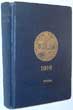
New York Yacht Club 1916.
Date. 1916.
New York, Published by New York Yacht Club & the The Knickerbocker Press. 8vo, [5 x 7ins].. Pp. 321 + 44 Coloured prints of Private Signals + 2 Coloured prints of Flags & Caps Ornaments. Original cloth gilt, slight rubbing..... £200.00 |
Click on picture above to view more images
How to order |
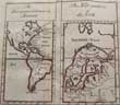
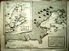
(Code No. 6330)
Cole, B.
(2 Antique maps on one page).
European Colonies in America & The Navigation of the North.
Date. 1760.
London: Stanley Crowder. Page size [7 x 8ins]. Original copper engraved folding map of the European Colonies in America & The Navigation of the North, very good condition.... £60.00 |
Click on picture above to view more images
How to order |
(Code No. 6206)
Rand-McNally.
Vest Pocket Map of SAN FRANCISCO.
No date, [c.1920].
San Francisco, Chicago...Rand McNally & Company. 12mo, [4 x 6 1/4ins]. Printed coloured folding map, (approx), [21 1/2 x 28 inches], very good condition. Showing streets, transportation lines, parks, public buildings, etc. Printed card wrapper, corners creased....... £60.00 |
Click on picture above to view more images
How to order |
(Code No. 6201)
Crawford, F. Marion. (1854-1909).
A Cigarette-Maker's Romance.
Date. 1891.
London, Macmillan. 8vo, [5 1/2 x 8ins]. .. Pp. 265. [1] 55 adverts]. Dedication on front free end paper. Original cloth gilt. Fine condition.
Francis Marion Crawford. American author, was born at Bagni di Lucca, Italy, being the son of the American sculptor Thomas Crawford and the nephew of Julia Ward Howe, the American poet. Year by year he published a number of successful novels. He was a gifted narrator, and his books of fiction, full of historic vitality and setting his plots amid picturesque surroundings....... £35.00
|
Click on picture above to view more images
How to order |
(Code No. 6158)
Mowbray, J. P.
The Making of a Country Home.
Date. 1902.
Westminster, Archibald Constable & Company. Ltd. 8vo, Pp. viii, 258, a few pages poorly separated, not affecting text + Designs by C. E. Hooper. Original cloth gilt, some marks...
When the book begins Mr & Mrs John Dennison were a young American couple living in New York on an income of between £500 and £600 a year . The man was a clerk in a business house "down town," and though his position was good, there was no outlet in his life for energy and ambition. So he and his wife determined to save nearly £200 a year for two years, and at the end of that time to buy a cottage in the country....... £70.00 |
Click on picture above to view more images
How to order |
(Code No. 6110)Kitchin. Thos.(Antique Map)MAP of the EUROPEAN SETTLEMENTS in NORTH AMERICA,by Thos. Kitchin, Hydrographer to His Majesty.Date. 1784.Dublin. John Exshaw. Image size [9 1/4 x 12 1/2 ins]. Page size [11 1/2 x 14 1/2 ins]. Copper engraved folding map taken from Abbe Raynal's (1713-1796) " A Philosophical and Political History of the Settlements and Trade of the Europeans in the East and West Indies" The map covers the eastern part of North America from Greenland to Florida with settlement confined to the eastern seaboard. The map has a garland style title cartouche, compass rose, two scale lines, (1" to 320 miles) and graduated borders. 1 inch closed split to centre fold, no loss. ..... .
|
SOLD
|
(Code No. 6107)
M'CLINTOCK (Captain).
The Voyage of the 'Fox' in the Arctic Seas.
A Narrative of the Discovery of the Fate of Sir John Franklin and his Companions.
Date. 1908.
London: John Murray. 8vo, [5 x 8ins]. Pp. 303 + Folding map + illustrations throughout, very good condition. Original half morocco. Raised spine bands with gilt decorated panels, very good condition. Prize label to front pastedown......... £50.00 |

Click on picture above to view more images
How to order |
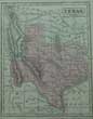
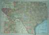
(Code No. 6072)LIZARS, WILLIAM. HOME, (1788-1859).Lizar's Edinburgh Geographical General Atlas ... with a tabular view of the heights of the great mountain chains ... engraved upon sixty-nine plates.Date. [c.1846] .Edinburgh, W. H. Lizars. Folio, [13 x 19ins]. Pp. 16, index + 69 (i.e. 68), double-page maps hand-coloured in outline, + Steel engraved illustration + pp [2]. (Plate 32 omitted in numbering), slight centre fold dust marks + a few spots . Original half morocco gilt, front board detached, poor. Two maps showing the "REPUBLIC OF TEXAS".The Republic of Texas was an independent sovereign nation in North America which existed from March 2, 1836, to February 19, 1846. It was bordered by the nation of Mexico to the southwest and the Gulf of Mexico. Formed as a separate nation after gaining independence from Mexico in 1836, the republic claimed borders that included all of the present US state of Texas based upon the Treaties of Velasco, claiming the boundary as the Rio Grande. This dispute would later become a trigger for the Mexican-American War from 1846 to 1848.........
|
SOLD.
|
(Code No. 6066)
Anon.
(Antique Print).
The Form of Landing, our Troops on the Island of Cuba for 1762.
Date. May 17 1763.
London, London Magazine. Image size [9 3/4 x 8ins]. Original copper engraved folding print + pp 4 of printed text, (approx,147 lines), of extracts from the journal of an officer at the besieging of Havana.
This small battle plan identifying the ships, their captains and the various regiments that took place at besieging of the Havana, Cuba. The Battle of Havana (1762) was a military action from March to August 1762, as part of the Seven Years' War. British forces besieged and captured the city of Havana, which at the time was an important Spanish naval base in the Caribbean, and dealt a serious blow to the Spanish navy. Havana was subsequently returned to Spain under the 1763 Treaty of Paris that formally ended the war....... £55.00
|
Click on picture above to view more images
How to order |
(Code No. 6058)Furness Warren Line.Plan of passenger accommodation R.M.S. "Nova Scotia" & R.M.S. "Newfoundland"Date. 1955.Britain. Furness Warren Line. Page size, (approx), [22 x 17ins]. Original folding coloured deck plan + Fares & General Information, nicks to outer margins.NOVA SCOTIA Official Number: 181096 Signal Letters: G N N K. Gross Tonnage: 7438; Nett: 4241. Length: 423.5ft, Breadth: 61.2ft. Built by Vickers-Armstrongs at Newcastle in 1947; registered at Liverpool. Owned by Johnston Warren Lines Ltd., (Furness, Withy & Colt., and Managers).3 steam turbines.NEWFOUNDLAND Official Number: 182403 Signal Letters: G N M C. Gross Tonnage: 7437; Nett: 4236. Length: 423.5ft, Breadth: 62.1ft. Built by Vickers-Armstrongs at Newcastle in 1948; registered at Liverpool. Owned by Johnston Warren Lines Ltd., (Furness, Withy & Co.Ltd, Managers).3 steam turbines. Both ships had accommodation for 62 first-class and 92 tourist-class passengers on a regular service from Liverpool to St Johns, Newfoundland; Halifax, Nova Scotia, and Boston, Massachusetts, USA. They were fine examples of the combined cargo and passenger liner; smaller examples of Cunard's MEDIA and PARTHIA.......
|
SOLD.
|
(Code No. 5963)
(Antique print).
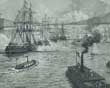
Opening of the New York and Brooklyn Suspension Bridge.
Date. 1883.
London: George C. Leighton, Page size [11 x 16 1/2ins]. Single page engraved view of the "Opening of the New York and Brooklyn Suspension Bridge" slight marks to outer margins, not affecting the image.
The Brooklyn Bridge in New York City is one of the oldest suspension bridges in the United States. Completed in 1883, it connects the boroughs of Manhattan and Brooklyn by spanning the East River. With a main span of 1,595.5 feet (486.3 m), it was the longest suspension bridge in the world from its opening until 1903........ £50.00 |
Click on picture above to view more images
How to order |
(Code No. 5865)Gillray, James.(Antique print).John Penn (1760-1834).Pen-etration..... .Date. 1799, 1st edition.London. Published by Hannah Humphrey. Image size, [7 1/4 x 10ins]. Original hand-coloured etched print, edge nick into engraved image and cropped to engraved border.John Penn (1729 -1795) was the last governor of colonial Pennsylvania, serving in that office from 1763 to 1771 and from 1773 to 1776. He was also one of the Penn family proprietors of the Province of Pennsylvania. The American Revolution removed the Penn family from power. The Penns were paid £130,000, a fraction of what the lands were worth. Gillray's satirical cartoon portrays John Penn as a dandy, dense, and dim-witted.......
|
SOLD.
|
(Code No. 5748)Murphy, W.(Antique Map).Map of North America.Date. 1828.Ebinburgh, Oliver & Boyd. Page size [8 1/4 x 7 1/2ins]. Original folding engraved map of North America, very good......
|
SOLD.
|
(Code No. 5671)
Mowat, Farley.
The Grey Seas Under.
Date. 1959.
London: Michael Joseph 8vo, [5 1/2 x 8 1/4ins]. Pp. 317.Original cloth gilt. Dust jacket, slight chipping to outer edges.
Farley Mowat describes the epic struggle of a small ocean-going salvage tug the Foundation Franklin against the Germans in WW2. She saved hundreds of ships and thousands of lives from the open sea along the coasts of Newfoundland, Nova Scotia and the Gulf of St Lawrence. ....... £35.00 |

Click on picture above to view more images
How to order |
(Code No. 5670)
Town Plan of Baltimore.
Date. 1902.
Baltimore. Deetjen Brothers. Size 28 x 21 ins folding to 6 x 3 1/2 ins. Folding sectional coloured town plan taken from the original plan by Rand Mcnally & Co, very good. Printed card covers, slight fraying. .....£50.00 |
Click on picture above to view more images
How to order |
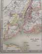
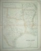
(Code No. 5635)
Johnston, W & A. K.
(Antique Map).
United States of North America.
(South East Sheet).
Date. 1893.
Edinburgh, London, W & A.K. Johnston. Page size [24 1/2 x 19 1/2ins]. Image size [22 1/2 x 17 1/4ins]. Original printed outline colour engraved map by W & A.K. Johnston , very good condition..... £40.00 |
Click on picture above to view more images
How to order |
(Code No. 5634)
Johnston, W & A.K.
(Antique Map).
United States of North America,
(North West Sheet).
Date. 1893.
Edinburgh, London, W & A.K. Johnston. Page size [24 1/2 x 19 1/2ins]. Image size [22 1/2 x 17 1/4ins]. Original printed outline colour engraved map by W & A.K. Johnston , very good condition..... £40.00 |
Click on picture above to view more images
How to order |
(Code No. 5630)
Johnston, W & A.K.
(Antique Map).
United States of North America,
(South West Sheet).
Date. 1893.
Edinburgh, London, W & A.K. Johnston. Page size [24 1/2 x 19 1/2ins]. Image size [22 1/2 x 17 1/4ins].Original printed outline colour engraved map by W & A.K. Johnston , very good condition..... £40.00 |
Click on picture above to view more images
How to order |
(Code No. 5629)
Johnston, W & A.K.
(Antique Map).
United States of North America.
(North East Sheet).
Date. 1893
Edinburgh, London, W & A.K. Johnston. Page size [24 1/2 x 19 1/2ins]. Image size [22 1/2 x 17 1/4ins].. Original printed outline colour engraved map by W & A.K. Johnston , very good condition...... £40.00 |
Click on picture above to view more images
How to order |
(Code No. 5524)Brooks, Noah.Abraham Lincoln and the Downfall of American Slavery.Date. 1902.New York: Putnam. 8vo, [5 1/4 x 8ins]. Pp xiv 471, vg + Full-page illustrations throughout. Prize full calf gilt with gilt dentelle borders. Raised spine bands with gilt-tooled panels, slight rubbing. Marbled edges and end papers.....
|
SOLD.
|
(Code No. 5477)
Lowell, James Russell, 1819-1891.
Poetical Works of James Russell Lowell including The Biglow Papers with prefatory memoir , notes glossary, etc.
Date. [c.1898]
London, Frederick Warne and Co. 8vo, [6 x 7 1/2ins.] Pp. xxi, 519. Original full calf. Raised spine bands with elaborate gilt-decorated panels. Previous owner's gilt-decorated device on upper cover. All edges gilt.
James Russell Lowell ( 1819 – 1891) was an American Romantic poet, critic, editor, and diplomat. He is associated with the Fireside Poets, a group of New England writers who were among the first American poets who rivaled the popularity of British poets. These poets usually used conventional forms and meters in their poetry, making them suitable for families entertaining at their fireside. Fine copy....£55.00 |

Click on picture above to view more images
How to order |
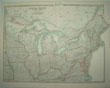
(Code No. 5362)Hinton, John Howard.The History of the United States of America, From the Earliest Period to the Present Time..5 of 6 Volumes, lacks volume 4 .Date. [c.1850]. London, J & F Tallis. 4to, [8 x 11ins. Pp. 784 + 43 Steel engraved view plates of America + 8 Steel engraved Tallis maps of America, (coloredin outline). Map list:- North America, Newfoundland and Nova Scotia, South America, United States, British America, East Canada New Brunswick, West Canada and Mexico California & Texas, very good condition. Original cloth gilt, slight rubbing. The British edition of this work is very rare....
|
SOLD.
|
(Code No. 5212)Glazier, Willard. Captain.Down The Great River; Embracing an Account of the Discovery of the True Source of the Mississippi .Date. 1889.Philadelphia, Hubbard Brothers. 8vo, [5 1/2 x 7 1/2ins.] pp. xxvi, [1], 443,liii, small corner piece missing from dedication page, not affecting text. + 34 full page view illustrations and maps, very good condition. Original decorated cloth, slight rubbing and marks.
|
SOLD.
|
(Code No. 5166)
Reid, Captain Mayne.
The Rifle Rangers or Adventures in South Mexico.
Date. [c.1880]
London, Ward & Lock. 8vo, [4 3/4 x 7ins]. Pp.448, Illustrations throughout. Original gilt-decorated cloth, faded. £45.00 |

Click on picture above to view more images
How to order |
(Code No. 5046)
POWNALL, Thomas, Governor of the Colony of Massachusetts Bay.
A Treatise on the Study of Antiquities As the Commentary to Historical Learning....... With an appendix.
Date. 1782, 1st edn
London, J. Dodsley. 8vo, [6 x 8 1/2ins.] . Pp. xxviii, 278 + 5 Copper engraved folding plates, slight foxing. Listing :- no. 1. On the elements of speech. 2. On the origin of written language, etc. 3. On the ships of the ancients. 4. On the chariots of the ancients. Original half calf, front hinge split. £220.00
At the Albany Congress, in 1754, Thomas Pownall met Benjamin Franklin, and a life-long friendship between the two resulted. In 1764 he published (at first anonymously) his famous Administration of the Colonies (other editions appeared in 1765, 1766, 1768), in which he advocated a union of all British possessions upon the basis of community of commercial interests. |
Click on picture above to view more images
How to order |
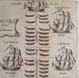
(Code No. 4923)(Antique North American Railway Prospectus).Nos.1 to 6. The Engine. an exact reproduction Southern Pacific.Date.1896.New York, J. Ottmann Litho & Co. 6 Loose original chromolithographic, (printed colour on card), prints of a Locomotive & 5 Carriages. Sizes [9 1/4 x 3 1/4ins] & [12 1/4 x 3 1/2ins.] All with descriptive text on the back of the images. Listing - destinations, engine and carriage arrangements, named railway agents for the various towns on route and timetables. Town listed: - Card no 1. New Orleans to San Francisco + Card no 2. Colton to Yuma + Card no 3. Maricopa to Lordsburg + Card no 4. Deming to Valentine + Card no 5. Sanderson to San Antonio + Card no 6. Guidden to New Orleans, marginal foxing. Very rare.
|
SOLD.
|
| (Code no. 4894)
Goodrich, Samuel G. (Samuel Griswold), 1793-1860.
Parley's Tales About Europe, Asia, Africa, America and Oceania.
Date. 1866.
London. William Tegg. 12mo, [4 1/2 x 51/2ins.] Pp. [4], 478. Full-page and text illustrations throughout, including 12 World Maps. Original gilt-decorated cloth. All edges gilt. £55.00
|

Click on picture above to view more images
How to order |
| (Code No. 4812)
Turner, Orsamus.
History of the Pioneer Settlement of Phelps and Gorham's Purchase, and Morris' Reserve.....
Date. 1851.
Rochester: Wm. Alling. 8vo, [6 x 9 1/4ins.] Pp 624, slight foxing throughout & Last pages with 9 margins with brown marks. Original cloth gilt, marked & cloth hinge split. Holding firm. £70.00
|
Click on picture above to view more images
How to order |
| (Code No. 4811)
Roderick, Edward & others.
Reports of the Inspectors of Mines of the anthracite and bituminous coal regions of Pennsylvania, for the year 1892.
Date. 1893.
Harrisburg. Edwin K. Meyers. 8vo, [7 x 9 1/2ins.] Pp xlv.476 + 11 plans of various collieries. Original cloth, slight marks. £50.00
|
Click on picture above to view more images
How to order |
(Code No. 4692)Maginnis, Arthur J.The Atlantic Ferry, its Ships, Men, and Working.Date. 1892. London. Whittaker and Co. 8vo, 5 1/2 x 7 1/2ins.Pp. xviii,304 + Illustrations throughout, some folding. Original gilt decorated cloth, slight rubbing.
The sailing vessels boasted an average passage of forty days to New York and twenty-three days home to Liverpool. The Atlantic steam liners halved the time. This book lists in depth the development of the ships, steam engines, speeds, etc and also listing their owners.
|
SOLD.
|
| (Code No. 4673)Gies Co.(Large Antique Panoramic Print.)Around the Niagara Falls and Through the Famous Gorge.Date. [c1900.] Buffalo. Image size [7 3/4 x 31ins.] Original Colour print. A panoramic view in a folding guide of the Niagara Falls. In its original mount, a few ink annotations, "I stood here". Also showing fold marks. Niagara Falls is composed of two major sections separated by Goat Island: Horseshoe Falls, on the Canadian side of the border and American Falls on the American side. The smaller Bridal Veil Falls also is located on the American side.
|
SOLD.
|
| (Code No. 4617)
NAYLOR, Robert Anderton.
Across the Atlantic .
Date. 1893.
London. Roxburghe Press. 8vo, 7 1/2 x 9 1/2ins. Pp xii 305, very good condition. "With the author's compliments, Guerdon Hall, Thelwall, Cheshire". Original cloth gilt, marked. Edges untrimmed. A record of a tour of the USA with the Arts Society who, along with the writer, visited the World's Fair at Chicago and other places of interest, e.g. New York, Washington. Niagara Falls, Montreal, and the Hudson River, etc. £70.00
|
Click on picture above to view more images
How to order
|
(Code No. 4570)
Bellin, Jacques Nicolas. (1703-1772).
(Antique Chart of Jamaica)
Carte de L'Isle la Jamaique Par le S. Bellin Ingen; de la Marine 1758.
Date. [c.1769]
Paris. Image size 8 X 12ins. Page size 14 x 10ins. Original hand-coloured copper engraved chart, very good condition. Shows, parishes, harbors, roads , mountains, rivers, etc. £90.00.
Jacques-Nicolas Bellin was a French hydrographer and cartographer. He was born in Paris. In 1721 Bellin was appointed hydrographer (chief cartographer) to the French Navy upon the creation of France's hydrographic office, the Dépôt des cartes et plans de la Marine. Appointed "ingénieur hydrographe" in August 1741.
Member of the Académie de Marine and of the Royal Society of London. Over a 50 year career, he produced a large number of maps of particular interest to the Ministère de la Marine. His maps of Canada and of French territories in North America (New France, Acadia, Louisiana) are particularly valuable. |
Click on picture above to view more images
How to order |
(Code No. 4567)Sanson. Nicolas.(Antique Map of Central America.)Audience de Guatimala. Par' N Sanson d' Abbeville Geogr' Ordin du Roy.Date. 1657-[c.1662.]Paris. Image size 7 x 10 1/2ins,(approx). Original copper engraved map, split to surface, professionally repaired on back of map. Taken from L' Amerique en Plusieurs Cartes. The map illustrates the region from the Yucatan to the Golfo de Panama, although much of the topography is incorrect. Lago de Nicaragua has an east-west orientation.
|
SOLD.
|
(Code No. 4566)Catherwood, F.C. Architect. (1799-1854) and John Lloyd Stephens,VIEWS OF ANCIENT MONUMENTS IN CENTRAL AMERICA, CHIAPAS AND YUCATAN.Date. [c.1970?] reprint of the 1844 edn.London: Vizetelly Brothers and Co. Large Folio, 17 x 21 1/2ins. (Approx) Image sizes 15 x 11ins. Title as above + 25 Loose coloured plates, (as issued) + Map of central America + Introduction pp.1-10 + Text (in smaller format) to plates, pp.11-24, housed in an inner front board pocket. Original cloth portfolio gilt, slight rubbing. Catherwood was 45 years old when he published a collection of his favorite illustrations. "Views of Ancient Monuments in Central America, Chiapas & Yucatán," in May 1844 in both London and New York, in a luxury edition of 300 sets. Catherwood become one of the most well-known architects and illustrators in the English-speaking world.
|
SOLD
|
(Code No. 4521)
BOWEN, Emanuel.
A New General Map of AMERICA. Drawn from several accurate particular Maps and Charts.
Date. 1747.
London, Page size 18 1/2 x 14 1/2ins. Image size 16 3/4 x 13 3/4ins. Original copper engraved map of North and South America, slight water staining to lower margin area. £300.00
Bowen was a prolific engraver and map seller in Fleet Street, from about 1720-67. He make his British County maps as complicated as possible, with blank areas filled with engraved text, coats-of-arms and rococo cartouches, etc. His later works seem to be more restrained, as can be seen in this American map. Ref :- P.J. Radford. Antique Maps. |
Click on picture above to view more images
How to order |
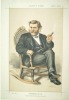
(Code No. 4291)
Original Vanity Fair Print.
GRANT Gen. Ulysses S, President of the United States of America.
London: Vanity Fair, 1st, June 1872.. Page size 15 x 10 Ins. Guaranteed original coloured lithograph. Titled - Captain, Tanner, Farmer. General, Imperator.
Ulysses S. Grant (1869-1877) was elected President as a war hero—the Northern General who’d defeated the South in the Civil War. £50.00 |
Click on picture above to view more images
How to order |
| (Code No. 4192)Tallis, John & J, Rapkin.(2 Antique Maps.) Comparative View of the Principal Waterfalls, Islands, Lakes, Rivers and
Mountains in the Eastern Hemisphere + Western Hemisphere.London. John Tallis & Co. ca1850. Page sizes, [10 1/4 x 14 1/2 ins] 2 Original steel engraved maps, (one folding),
drawn and engraved by John Rapkin. Taken from "Montgomery Martin's Illustrated Atlas" |
SOLD |
(Code No. 4156)
SWANSTON, G.H.
(Antique Map).
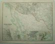
UNITED STATES according to CALVIN, SMITH & TANNER..North America, Comprising Texas, Louisiana , Mississippi, Arkansas, Western Territory, and Part of Missouri.
Edinburgh. London . A. Fullarton .1860. Image Size 16 x 20 1/4 ins, (approx). Original double page coloured engraved map by G.H. Swanston, split to centre fold not affecting engraved area. £45.00 |
Click on picture above to view more images
How to order |
(Code No. 4158)BARTHOLOMEW, J.(Antique U.S.A. Town Plans)Southern Ports & Harbours in the United States. Washington, Beaufort Harbour, Mobile Bay, Charleston Harbour, Galveston Entrance, Pensacola Bay, Key West Island, the Delta of Mississippi and environs.Plate 60a.Edinburgh. London. A. Fullarton .1860. Image Size 11 1/2 x 17 ins. Original single page coloured engraved map by J. Bartholomew.
|
SOLD.
|
(Code No. 4157)
BARTHOLOMEW, J.
(Antique U.S.A. Town Plans)
Northern Ports in the United States. Portland Harbour, Boston Harbour and vicinity, Hudson River, New York Harbour and vicinity, Philadelphia, and Baltimore.
Plate 60.
Edinburgh. London . A. Fullarton .1860. Image Size 11 1/2 x 17 ins. Original single page coloured engraved map by J. Bartholomew. £45.00 |
Click on picture above to view more images
How to order |
(Code No. 4145)Swanston G.H.(Antique Map of the U.S.A.)United States North America.Edinburgh. A Fullarton. ca1860. Page size 23 x 18 1/2 ins. Original steel engraved map, hand-coloured in outline, Taken from "Royal Illustrated Atlas of Modern Geography"
|
SOLD.
|
(Code No. 4118)The Encyclopaedia Britannica.Volume. 34 only.(Map volume).Edinburgh, London. Adam and Charles Black. 1903 10th edn. Medium 4to [9 x 12ins]. Pp 428 ,vg. 124 Double page coloured world maps, Scottish map damaged, including 66 double page coloured maps of separate American States, decorated with piano key borders, most U.S.A state maps with inset town plans, vg. Single sided. Half morocco gilt. Raised spine bands with gilt decorated panel, poor. Heavy book.
|
SOLD.
|
(Code No. 4057)Sketch showing the Lines Converging on Jersey City and the Hudson Tunnel Railway.London. Straker Bros & Co. ca1890. Image size 14 x 17 ins. Page size 15 x 19 ins. Original printed coloured lithographic folding map, foxing and splits, (2 ins). with a view of Jersey City, New York and Brooklyn below the map.
|
SOLD.
|
(Code No. 4036)Dodge. Richard, Irving.The Hunting Grounds of the Great West: A Description of the Plains, Game, and Indians of the Great North American Desert.London. Chatto & Windus. 1877, 1st edn.. 8vo, [6 x 9 ins]. Pp lvii, 440, 36 publisher's adverts + folding map, split to fold, no loss + illustrations throughout. Original gilt decorated cloth, very worn with some loss to spine.
|
SOLD.
|
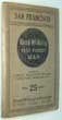
(Code No. 3829).
Anon.
A PLAN OF THE CITY & HARBOUR OF LOUISBURG; SHEWING THAT PART OF GABARUS BAY IN WHICH THE ENGLISH LANDED, ALSO THEIR ENCAMPMENT DURING THE SIEGE IN 1745.
London. Gentleman's Magazine. 1758. Image size 10 x 7 1/2 ins. Page size 11 x 8 1/4 ins. Original copper engraved map, slight nicks to borders. Showing an inset map of the Island of Cape Breton. £60.00 |
Click to view more images
How to order |
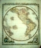
(Code
No. 3800).
Macdonald. D.
(Antique map of the Western Hemisphere).
Western Hemisphere. "New Sixpenny Maps, Embracing
the Most Recent Discoveries"
Glasgow. D. Macdonald, 51 Argyll Street.
ca1850. Page size 15 x 17 1/2 ins. Image size 14 1/2 x 13 ins. Original
steel engraved hand coloured map , slight damage with crease to
the centre of map. £110.00 |
Click to view more images
How to order |
(Code
No. 3806)
Russell, John.
(Antique Map of the British Colonies in North America).
British Colonies In North America from the best Authorities.
London. Published as the Act directs
by C.Dilly and others. 1799. Page size 22 x 17 ins. Image size 18
x 15 1/2 ins. Original copper engraved map by John Russell. From
the Guthries's Geography, slight damage to bottom margin. £110.00 |
Click to view more images
How to order |
(Code
No. 3803).
Macdonald. D.
(Antique map of British America).
British America " New Sixpenny Maps, Embracing the
Most Recent Discoveries"
Glasgow. D. Macdonald, 51 Argyll Street.
ca1850. Page size 15 x 17 1/2 ins. Image size 14 1/2 x 13 ins. Original
steel engraved hand coloured map . £85.00
|
Click to view more images
How to order |
(Code
No. 3734).North America. New York. 1892. Folio, [15 x 10
1/2 ins.] 34 Image sizes 9 x 7 ins, (approx) & 9 image sizes
4 1/2 x 7 1/2 ins, (approx). 29 Photographs of New York.
14 Photographs of Montreal, Toronto & 4 of Niagria Falls.
Only 3 Photographers named. Ink title below each image. Original
morocco gilt, poor condition. |
SOLD |
(Code No. 3739).
The Illustrated London News. 1883.
(Antique Sporting Print).
Lacrosse "The Canadian Game of La Crosse"
London. June 20th, 1883. Page size 16
x 11 ins. Image size 9 x 12 1/2 ins. Woodcut illustration (uncoloured,
as published), of "The Canadian Game of La Crosse", slight marks
to the outer edge of the blank margins. £50.00 |
Click to view more images
How to order |
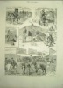
(Code No. 3738).
The Graphic. An Illustrated Weekly Newspaper. 1887.
(Antique Print).
"Capturing Wild Horses on the Laramie Plains, North
Western America".
London: The Strand. September 24th,
1887. Page size 23 1/2 x 16 ins. Image size 18 1/2 x 13 ins. Large
double page woodcut illustration (uncoloured, as published), of
a print titled, "Capturing Wild Horses on the Laramie Plains,
North Western America", very good condition. £60.00 |
Click to view more images
How to order |
(Code
No. 3737).
The Graphic. An Illustrated Weekly Newspaper. 1887.
(Antique Print).
"With the Texas cow-boys"
London: The Strand. August 6th, 1887.
Page size 16 x 11 1/2 ins. Image size 12 x 9 ins. Woodcut illustration
(uncoloured, as published), of a print titled "With the Texas
cow-boys", very good condition. £50.00 |
Click to view more images
How
to order |
(Code
No. 3736).The Illustrated London News. 1883.(Antique Print).The Brooklyn Bridge over the East River, between Long Island
and New York.London. June 2nd, 1883. Page size 16
x 11 ins. Image size 7 1/2 x 12 ins. Woodcut illustration (uncoloured,
as published), of the Brooklyn Bridge (originally the New York and
Brooklyn Bridge), one of the oldest suspension bridges in the United
States, stretches 5,989 feet (1825 m) [1] over the East River connecting
the New York City boroughs of Manhattan and Brooklyn. On completion,
it was the largest suspension bridge in the world and the first
steel-wire suspension bridge.
|
SOLD.
|
| (Code No. 3601). London.Gentleman's Magazine. Image size 8 1/2
x 13 ins. 1757. Copper engraved folding map, very slight splits
to fold and one nick into graduated border. Showing various forts,
northern tribes, etc.
|
SOLD |
(Code No. 3499)Bache. A.D. ( Antique US Chart )San Antonio Creek, California.US Coast Survey Office.
Image size 19 x 13 1/2 ins.1857. Original US lithographic folding
chart by R. F. Bartle from a drawing by P. Witzel. Guaranteed to
be over 120 years old.
|
SOLD.
|
(Code No. 3500)
US Coast
Survey Office. Image size 35 x 24 1/2 ins.1857. Original US lithographic
folding chart engraved by J. Knight from the original drawing by
M.M.C Fairfax, slight cropping to left side &. slight splits
to folds,Guaranteed to be over 120 years old. |
SOLD |
(Code No. 2453)Aspin. Johoshaphat. (Antique Map).
North & South AMERICA, for the Elucidation of the Abbe
Gaulier Geographical Games.
London. John Harris. 1832. size 19 x 16 ins. Image size 13 1/2 x 17
ins. Original Hand Coloured Copper Engraved Map of North &
South America by Hewitt, creaseing to center fold, good condition. Guaranteed
to be over 150 years old.
|
SOLD
|
(Code No. 3391)
Bonne, Rigobert: ( Map of the East Coast of U.S.A.)
Carte de la Partie Sud des Etats Unis de l'Amerique Septentrionale.
Paris, 1790. Image size 8 1/2
x 12 1/2 inches. Page size 17 x 10 inches. Original copper engraved
map, engraved by Andre', slight foxing. Showing Virginia, North
and South Carolina, Georgia, Cherokee and Creeks Indian territory.
Maps based on the longitude meridian of Paris. £75.00 |

Click to view more images
How
to order |
| (Code No. 3344) London:
A. Hogg. Image Size 14 1/2 x 13 ins. Page Size 19 x 15 ins. 1782.
Original folding copper engraved map. This map covers from Canada
to Florida and from Newfoundland to the West of the Mississippi River.
Compass Indicator. Scale 290 miles to the Inch. Decorative Cartouche.
Inset map of "East Florida Continued" and Graduated border.
Slight split to fold, repaired. |
SOLD |
| (Code No. 3345)
London: A. Hogg. Image Size, approx 14 1/2 x 13 ins. Page
Size 19 x 15 ins. 1782. Original folding copper engraved map, from
Millar's Universal Geography. Decorative title cartouche Includes
native Americans. Graduated border. Slight split to fold, repaired. |
SOLD |
| (Code No. 3351) London. A Hogg. Image
size 12 x 8 ins. Page size 15 x 9 1/2 ins. 1770. Original folding
copper engraved map from.The New &, Complete & Universal System
of Geography. Decorative title cartouche. New Holland (Australia)
showing Tasmania joined to the main land. Ornamental borders. |
SOLD |
(Code No. 3184)
Mitchell. Augustus.
S Mitchell's Intermediate or Secondary Geography, Revised Edition. A System of Modern Geography, Comprising a Description of the Present State of the World.
Date. 1858.
Philadelphia: H. Cowperthwait & Company. 4to, [10 x 12 ins]. Pp 78, 6, some slight spotting. 41 HAND COLOURED ENGRAVED WORLD MAPS, some spotting. Text wood-cut engravings throughout. Original pictorial boards, rubbed & spine, poor condition..... £130.00 |
Click to view more images
How to order |
| (Code no.2892)
London. Bew. Dec 1782.
Map image size 14 1/4 x 11 ins. Copper engraved folding map by
J Lodge, split into border (2 ins). Compass Rose, A detailed map
showing towns, forts, boundaries etc. |
SOLD |
(Code No.2908)Smith & Jones.. (Antique
Map showing "MORGANIA" & "FRANKLINIA" ):EASTERN UNITED STATES. (Map
of the United States, Canada the River St. Lawrence, the Lakes &c).London. Richard Phillips. ca1800.. Image
size 16 x 12 1/2 ins. Page size 16 1/2 x 14 ins. Copper engraved
folding map by Smith & Jones. This is very uncommon map of the
fledgling nation. In New England, Maine is shown with a truncated
northern boundary. Georgia's western boundary is the Mississippi
River. The border with Florida, then a Spanish territory, is located
on the 31st parallel and marked "Land Claimed by the United
States". The proposed state of "FRANKLINIA" is located
in eastern Tennessee. This 'state' of Franklin was formed in 1784,
Franklinia was never recognized by Congress and eventually was re-annexed
by North Carolina. The region west of the Mississippi River (present-day
Missouri and Arkansas) is named "MORGANIA". At the time,
this region was Spanish territory. The colony, also known as New
Madrid, lasted but a short while, vg. This map is probably the 1st
state, not having titles above and below the image.
|
SOLD.
|
| (Code no. 3288)London.Edinburgh.
Blackwood and Son. ca1860, approx size, 24 x 19 1/2 ins. 7 Hand-coloured
in outline double page American maps, (all loose, no text or covers).
Numbers 41,42,43,44,45,47,48, (no.46 Mexico, missing.) Engraved and
Printed by W & A.K. Johnston. Showing, North America, Province
of Canada, Province of Canada (New Brunswick, New Foundland etc),
U.S.A (Western States,) U.S.A. (Eastern States,) South America, (Northern
Sheet,) South America, (Southern Sheet,) |
SOLD |
(Code No: 2784)
Lodge. J. ( Antique Chart )
"New and Accurate Chart of HUDSON'S BAY
in NORTH AMERICA"
London. Bew. Nov 1782. Map image size 8 3/4 x 7 ins.
Copper engraved folding map by J Lodge, Compass indicator. A detailed
map showing forts and new discovered areas etc. Areas shown, North
tip ot Lake Superior to Repulse Bay, east to Greenland and south
to north of Newfoundland and Nova Scotia. £80.00 |

Click to view more images
How
to order |
(Code
No.3015)Tallis, John:West Canada [Antique Map.]
London. Ca 1850. Size Approx 360 x 275mm. Original steel engraved
map with original outline hand colouring. 4 vignette views which
includes Niagara Falls. Decorated border. Centre fold, |
SOLD |
| (Code No.2292) London. ca1850. Page size 15 x 11 ins. Original single page steel
engraved drawn and engraved by J. Watkins, the
plan drawn by J. Rapkin +3 vignette views of State House, Bunkers
Hill very good. |
SOLD |
| (Code No. 2052)
Anon.
International Atlas. The United States. The World. Indexed. Containing separate Maps of each State of the United States.
Chicago. Thompson & Thomas. 1903. Folio [12 x 15ins].Pp 258, some nicks to edges, not affecting images. 55 Full-page & double page coloured lithograph maps of separate American States & 29 full-page & double page coloured lithograph World maps. 5 Coloured full-page statistical diagrams. Maps on both sides of page leaf. The state maps are in rich colours and most have statistical details to sides of maps listing the counties, chief cities and population numbers according to the 20th official census. Original decorated cloth, rubbed and slight fading. £130.00 |
Click to view more images
How to order |
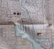
| (Code No.2250) London. ca1850. Size 20 3/4 x 15 ins. Original double page steel engraved
drawn and engraved by H. Winkles, the plan by
J.Rapkin + 6 vignette views of New York from Willamsburgh, The Narrow
from Fort Hamilton, Custom House, City Hall, and a
Steamer. Decorative boarder. All streets, dock-yards areas and ferry
routes are listed, Slight foxing. |
SOLD |
Return to top |
|