SITE CONTENT
Antique Maps & Prints
Britain
Antique Maps - World
Antique Books
Cartographers
Early Prints
Other Stock
|
| Maps & Prints of The Midlands |
Images |
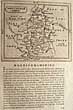
(Code No. 6842)
Fullarton. A & Scott, H.
(Antique Map).
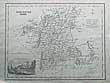
Worcestershire.
Date. (c.1833}.
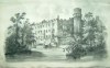
London. Fullarton & Co .Page size [11 x 8 1/2ins].. Original steel engraved map with a vignette of Newstead Abbey engraved by H. Scott. 2 Horizontal folds, as issued. Map taken from "A NEW AND COMPREHENSIVE GAZETTEER OF ENGLAND AND WALES".......... £25.00 |
Click on picture above to view more images
How to order |
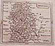
(Code No. 6841)
Fullarton. A & Scott, H.
(Antique Map).
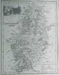
Nottinghamshire.
Date. (c.1833}.
London. Fullarton & Co .Page size [11 x 8 1/2ins].. Original steel engraved map with a vignette of Newstead Abbey engraved by H. Scott. 2 Horizontal folds, as issued. Map taken from "A NEW AND COMPREHENSIVE GAZETTEER OF ENGLAND AND WALES"..... £25.00 |
Click on picture above to view more images
How to order |
(Code No. 6802)
History of Shropshire:
Volume IV:
Date. 1989.
Agriculture (Victoria County History). Published by University of London Institute of Historical Research , Oxford University. Folio [12 x 9ins]. Pp. xix, 293 + photographs and maps, .Original cloth gilt with dust jacket..... £55.00 |
Click on picture above to view more images
How to order |
(Code No. 6801)
Grose. Francis,
(ANTIQUE MAP)
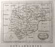
RUTLANDSHIRE.
Date. [c.1780].
London. Approx size 250mm x 170mm, Original copper engraved map, with descripitive text below the map. The map is a reprint of John Seller's map, dated 1701, from [Camden's Britannia abridged, J. Wild]...... £25.00 |
Click on picture above to view more images
How to order |
(Code No. 6754)
Auden, Thomas.
SHREWSBURY: A HISTORICAL TOPOGRAPHICAL ACCOUNT OF THE TOWN.
Date. 1905 1st edn.
London : Published by Methuen & Co. 8vo, [8 x 5 1/2ins]. . Pp. xv, 305, [40 adverts] + illustrations throughout. Illustrated by Katharine M. Roberts. Original gilt decorated cloth. Owner's name on front past down. Rear cloth hinge split and fading marks. Holding firm...... £35.00 |
Click on picture above to view more images
How to order |
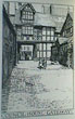
(Code No. 6747)
Forrest, H. E.
The Old Houses of Wenlock and Wenlock Edge, Their History and Associations.
Date. 1915, 2nd edition.
Shrewsbury, Wilding and Son Limited. 12mo, [5 x 7 1/2ins]. Pp. viii,130, [11] + Illustrations throughout, very good. Soft covers, slight nicks to edges. Some Houses Listed:- Shipton Hall, Coverdale, Madeley, Wolverton Hall, Alcaston Manor..Rushbury manor, Bourton Hall, More hall, Larton Hall, Aston Hall...... £30.00 |
Click on picture above to view more images
How to order |
(Code No. 6732)
GROSE, Francis / Seller. J.
Map of NOTTINGHAMSHIRE.
(Antique Map).
Date. . 1798.
London, Sold by H. H Symonds. Page size [7 x 10ins] Original copper engraved map, The map is a reprint of John Seller's map Camden's Britannia abridged, J. Wild...Francis Grose had shown a keen interest in drawing, having attempted sketches of medieval buildings as far back as 1749, and having taken formal instruction at a drawing school 1750s. He was not a particularly gifted draughtsman but he mixed in the London artistic group and began to exhibit, first at the Society of Artists in 1767-8 and then at the Royal Academy. His interest was in the field of medieval remains......... £25.00 |
Click on picture above to view more images
How to order |
(Code No. 6668)
GROSE, Francis / Seller. J.
Map of SHROPSHIRE.
(Antique Map).
Date. 1798.
London, Sold by H. H Symonds. Page size [7 x 10ins]. Original copper engraved map, The map is a reprint of John Seller's map Camden's Britannia abridged, J. Wild...
Francis Grose had shown a keen interest in drawing, having attempted sketches of medieval buildings as far back as 1749, and having taken formal instruction at a drawing school 1750s. He was not a particularly gifted draughtsman but he mixed in the London artistic group and began to exhibit, first at the Society of Artists in 1767-8 and then at the Royal Academy. His interest was in the field of medieval remains...... £25.00 |
Click on picture above to view more images
How to order |
(Code No. 6427)
New 1 Inch Ordnance Survey of England and Wales.
Radnorshire & Shropshire. Sheet 180.
(Antique Map).
Date.1890.
London, Edward Stanford. [19 1/2 x 13 1/4ins] folding to [6 1/2 x 4ins] . 10 Seconal hand-coloured linen backed map.Scale of one inch to a statute mile = 1 : 63,360...... £30.00 |
Click on picture above to view more images
How to order |
(Code No. 6417)
Sanderson, Fred.
Poor Law Union Parish Map of the County of NOTTINGHAM exhibiting in a comprehensive manner the Railway System of the district..
Date. 1st Dec 1861.
London, Published by Job Bros, 8vo, [4 1/2 x 6 1/2ins] Original hand-coloured folding map with large vignette view of Clumber House. Page size [21 1/2 x 29ins]. Printed covers, slight marks...... £75.00 |
Click on picture above to view more images
How to order |
(Code No. 6165)
Bowen, Emanuel.
(Antique Map).
The Counties of Leicester & Rutland Divided into Hundreds.
Containing the County and Market Towns...
Date. 1761.
London : Printed and sold by W.Owen. Page Size [8 x 9ins]. Original hand-coloured engraved map, very good condition. (Later hand-colouring). Below the bottom border is “Engrav’d for the General Magazine of Arts & Sciences; for W. Owen at Temple Bar 1761"....... £65.00 |
Click on picture above to view more images
How to order |
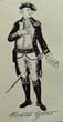
(Code No. 6121)
Wylly, Colonel. H. C.
2 Volumes.
Regimental Annual: The Sherwood Foresters, Nottingham and Derbyshire Regiment, 1933 & 1937.
Date. 1933 & 1937.
London, Bemrose & Sons Ltd. 8vo. Ex Library, (marginal embossed stamps). Pp. (approx 270 & 317 pages per volume) + Illustrations throughout. Original cloth gilt. spines faded.
The Sherwood Foresters (Nottinghamshire and Derbyshire Regiment) was formed during the 1881 Childers Reforms of the British Army. The 45th (Nottinghamshire) Regiment of Foot (raised in 1741) and the 95th (Derbyshire) Regiment of Foot (raised in 1823) were redesignated as the 1st and 2nd battalions of The Sherwood Foresters (Derbyshire Regiment). The Derbyshire and Royal Sherwood Foresters Militias (militia and rifle volunteers) became the 3rd (Robin Hood Rifles) and 4th Battalions respectively. These were joined by the 1st and 2nd (Derbyshire) and the 3rd and 4th (Nottinghamshire) Volunteer Battalions. The Headquarters of the Regimental District was established at Derby. In 1902, the Nottinghamshire association was made explicit, the name changing to The Sherwood Foresters (Nottingham and Derbyshire) Regiment. Following a series of mergers since 1970, its lineage is now continued by the 2nd battalion, the Mercian Regiment.......... £40.00 |
Click on picture above to view more images
How to order |
(Code No. 6074)
Wylly, Colonel. H. C.
2 Volumes.
Regimental Annual: The Sherwood Foresters, Nottingham and Derbyshire Regiment, 1926 & 29.
Date. 1926 & 29.
London, George Allen.. 8vo, Ex Library, (marginal embossed stamps). Pp. (approx 260 pages per volume), lacks fly leafs + Illustrations throughout. Original cloth gilt..marked.
The Sherwood Foresters (Nottinghamshire and Derbyshire Regiment) was formed during the 1881 Childers Reforms of the British Army. The 45th (Nottinghamshire) Regiment of Foot (raised in 1741) and the 95th (Derbyshire) Regiment of Foot (raised in 1823) were redesignated as the 1st and 2nd battalions of The Sherwood Foresters (Derbyshire Regiment). The Derbyshire and Royal Sherwood Foresters Militias (militia and rifle volunteers) became the 3rd (Robin Hood Rifles) and 4th Battalions respectively. These were joined by the 1st and 2nd (Derbyshire) and the 3rd and 4th (Nottinghamshire) Volunteer Battalions. The Headquarters of the Regimental District was established at Derby. In 1902, the Nottinghamshire association was made explicit, the name changing to The Sherwood Foresters (Nottingham and Derbyshire) Regiment. Following a series of mergers since 1970, its lineage is now continued by the 2nd battalion, the Mercian Regiment......... £40.00
|
Click on picture above to view more images
How to order |
(Code No. 6065)
Wylly, Colonel. H. C.
3 Volumes.
Regimental Annual: The Sherwood Foresters, Nottingham and Derbyshire Regiment, 1930-32.
Date. 1930, 1931, 1932.
London, Butler & Tanner Limited. 8vo, Ex Library, (marginal embossed stamps). Pp. (approx 270 pages per volume) + Illustrations throughout. Original cloth gilt..
The Sherwood Foresters (Nottinghamshire and Derbyshire Regiment) was formed during the 1881 Childers Reforms of the British Army. The 45th (Nottinghamshire) Regiment of Foot (raised in 1741) and the 95th (Derbyshire) Regiment of Foot (raised in 1823) were redesignated as the 1st and 2nd battalions of The Sherwood Foresters (Derbyshire Regiment). The Derbyshire and Royal Sherwood Foresters Militias (militia and rifle volunteers) became the 3rd (Robin Hood Rifles) and 4th Battalions respectively. These were joined by the 1st and 2nd (Derbyshire) and the 3rd and 4th (Nottinghamshire) Volunteer Battalions. The Headquarters of the Regimental District was established at Derby. In 1902, the Nottinghamshire association was made explicit, the name changing to The Sherwood Foresters (Nottingham and Derbyshire) Regiment. Following a series of mergers since 1970, its lineage is now continued by the 2nd battalion, the Mercian Regiment...... £65.00 |
Click on picture above to view more images
How to order |
(Code No. 6055)Wylly, Colonel. H. C.2 Volumes.Regimental Annual: The Sherwood Foresters, Nottingham and Derbyshire Regiment, 1921-22.Dates. 1921-22.London, George Allen.. 8vo, . . Ex Library, (marginal embossed stamps). Pp. (approx 260 pages per volume) + Illustrations throughout. Original cloth gilt..marked. ..The Sherwood Foresters (Nottinghamshire and Derbyshire Regiment) was formed during the 1881 Childers Reforms of the British Army. The 45th (Nottinghamshire) Regiment of Foot (raised in 1741) and the 95th (Derbyshire) Regiment of Foot (raised in 1823) were redesignated as the 1st and 2nd battalions of The Sherwood Foresters (Derbyshire Regiment). The Derbyshire and Royal Sherwood Foresters Militias (militia and rifle volunteers) became the 3rd (Robin Hood Rifles) and 4th Battalions respectively. These were joined by the 1st and 2nd (Derbyshire) and the 3rd and 4th (Nottinghamshire) Volunteer Battalions. The Headquarters of the Regimental District was established at Derby. In 1902, the Nottinghamshire association was made explicit, the name changing to The Sherwood Foresters (Nottingham and Derbyshire) Regiment. Following a series of mergers since 1970, its lineage is now continued by the 2nd battalion, the Mercian Regiment........
|
SOLD.
|
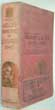
(Code No. 5956)
Kelly.
Kelly's Directory of the City of LEICESTER.
Date. 1947.
London, Kelly's Directories Ltd. Large 8vo. Pp xxx, 824. Original cloth, faded.
Listing:- The history and the names, trades and addresses of the inhabitants, transport, postal and telegraph information. The accountants to the
Woollen Drapers
...... £50.00 |
Click on picture above to view more images
How to order |
(Code No. 5844)Hamilton EllisThe Midland Railway.Date. 1953 1st edn.London, Ian Allan. 8vo, [6 x 9ins]. Pp. viii, 192 + Illustrations throughout + folding map. Original cloth. Dust jacket, slight chipping.The Midland Railway (MR) (1844 to 1922), when it became part of the Railway. The Midland Railway had a large network of lines, with its headquarters based in Derby. Initially connecting Leeds with London (St Pancras) via the East Midlands by what is now the Midland Main Line, it went on to connect the East Midlands with Birmingham and Bristol, and with York and Manchester. It becoming the third largest railway undertaking in the British isles, and the largest coal haulier.......
|
SOLD.
|
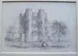
(Code No. 5813)
Anon.
Pencil Sketch of The Gate House, Kenilworth, Warwickshire.
Date. [c.1840].
England. Image size, [6 1/2 x 4ins]. Original mounted pencil sketch by an unknown talented artist. (Modern mount).
In 1571-2 Robert Dudley (Earl of Leicester) erected a gatehouse at the northern end of the outer court of Kenilworth Castle. It is a two storied, rectangular sandstone building with octagonal corner turrets and mullioned and transomed windows. Originally it would have straddled the medieval curtain wall (removed in 1650), and featured an entrance passage wide enough for carriages at ground level and two floors of lodgings above. It was built in the tradition of a medieval gatehouse...... £50.00 |
Click on picture above to view more images
How to order |
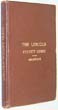
(Code No. 5554)
Anderson, C.H.J.
The Lincoln Pocket Guide : Being a Short Account of the Churches and Antiquities of the County.
Date. 1892.
London,Edward Stanford. 8vo, [4 1/2 x 7ins]. pp x,192 + Folding map, split to fold, no loss + Illustrations, very good. Original cloth gilt, very good..... £45.00 |
Click on picture above to view more images
How to order |
(Code No. 5358)Hawtree, J. (Surveyor).Worthington & Co. Ltd. Brewers & Maltsters. Burton on Trent, Stafordshire.Date. 3rd December 1908London, Atlas Assurance Co. Ltd. 92 Cheapside, E.C. Page size [46 x 36ins] folding to [9 3/4 x 11ins].. Wash colour, linen backed lithographic Plan, discected into 15 sections. Drawn for Insurance purposes only. Scale :- 40 feet to 1 inch.The Worthington Brewery, started by William Worthington in 1744, merged with Bass in 1926, and was later amalgamated with Mitchells and Butlers of Birmingham in 1961 and with Charrington’s of London in 1967...
|
SOLD.
|
(Code No. 5246)
Phillips, J. & W. Hutchings.
A Map of the County of Stafford divided into Hundreds & Parishes from an Accurate Survey made in the Year 1831 and 1832.
Date.1831-1832.
London, Henry Teesdale. Size: 54 x 39 1/2ins folding to 10 x 5 1/2ins. A 40 sectional linen backed hand-coloured map, very good condition. Showing compass rose + 19 line colour coded "Explanation" + 10 Line colour coded "Notes" (polling places, boundary divisions, etc + Scale: one inch = one and one third miles + Large vignette of "South East view of Lichfield Cathedral". Original full leather slip case, gilt-tooled roll frame. Spine in seven compartments with elaborate gilt-tooling, slight rubbing. Marbled edges. £700.00 |
Click on picture above to view more images
How to order |
(Code No. 5140)Manning. J.C.Royal Leamington Spa. Glimpses of Our Local Past Incidental to the Rise and Progress.Date. 1895.Leamington Spa. F, Glover. 12mo, [4 1/4 x 6 1/4ins.] Pp. (9) 181, xxxvi + 8 full page plates, vg. Original cloth gilt, vg. An interesting book that deals with the topography and local history, mostly from the memory of its local citizens
|
SOLD.
|
| (Code No. 4980)
Cole. W.
South West View of Warwick Castle.
(Antique Print).
Date. 1825.
London, William Cole. Page size [20 x 12ins.] Original large lithographic engraved print, slight marks. £60.00
Warwick Castle is a medieval castle in Warwick, the county town of Warwickshire, England. It sits on a cliff overlooking a bend in the River Avon. Warwick Castle was built by William the Conqueror in 1068 within or adjacent to Anglo-Saxon burh of Warwick. It was used as a fortification until the early 17th century, when Sir Fulke Greville converted it to a country house. It was owned by the Greville family, who became earls of Warwick in 1759, until 1978.
|
Click on picture above to view more images
How to order |
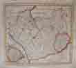
| (Code No. 4914)Beighton. Henry.( Antique Map that includes Stratford upon Avon in the County of Warwickshire).A Map of Barlichway Hundred Reduc'd from an Actual Survey made in the year 1725. By Hen: Beighton Fellow of the Royal Society. 1729. Date. 1729.Page size, 16 x 17ins. Original copper engraved folding map, nicks to outer edges, not affecting the image. The present Hundred of Barlichway comprises the earlier Hundreds of 'Fernecumbe' and 'Patelau', together with the parishes of Tanworth, Packwood, and Lapworth, which, until 1833, formed a detached part of Kington Hundred. Its boundaries on the west and south are the same as those of the county, on the north is the Hundred of Hemlingford, and on the east are the Hundreds of Knightlow and Kington.. Townships listed, Snitterfield, Stratford upon Avon, Aston Cantloe, and Bishopton, etc.
|
SOLD.
|
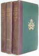
| (Code No. 4897)Gill, Conrad & ASA. Briggs.History of Birmingham.2 volumes.Date. 1952.London, Oxford Univerity Press. 4to, 6 1/2 x 10ins. Pp, xiii, 454. xi, 384 + Illustrations throughout + 4 Large folding Birmingham town plans in end pockets, (as listed), very good. Original cloth gilt, very good. Dust jackets, splits to outer edges with slight loss.
|
SOLD.
|
| (Code No. 4817)Moule, Thomas.Shropshire .(Antique Map, Guaranteed over 140 yrs old ).Date. [1836 -52.]London. Virtue. Page size 10 3/4 x 8 1/2ins. Original steel engraved hand-coloured county map of Shropshire . Decorated with vignettes, view of Ludlow Castle, Bridgenorth and Grammar School, Shrewsbury. Ornamental border with symbolic figures woven into the design, heraldic coat of arms. Moule's county maps are the last series of decorative maps to be published.
|
SOLD.
|
(Code No. 4584)
An Act for Dividing, Allotting and Inclosing the Common Fields, Marsh Meadow, and Wast Lands, in the Manor of Forebridge and in the Parish of Castle Church, in the County of Stafford; and for embanking and Draining Part of the Said Common Field......
Date. 1851.
London. 4to, 8 x 12ins. Pp 42, some taped margins and last page missing. Original cloth, part of spine cloth missing. Holding firm. £45.00
|
Click on picture above to view more images
How to order |
(Code No. DP4092)Bowen, Emanuel, John Owen, & John, Ogilby.(Antique Map & Strip Road Map.)NORTHAMPTONSHIRE.London. T, Bowles. King of Spain. 1720-64.. Size of page, 6 x 8 ins. Original
copper engraved County map + strip road map, both taken from "Britannia Depicta or Ogilby Improv'd",
very good condition.
|
SOLD.
|
(Code No. DP4091)Bowen, Emanuel, John Owen, & John, Ogilby.(Antique Map & Strip Road Map.)LEICESTERSHIRE.London. T, Bowles. King of Spain. 1720-64.. Size of page, 6 x 8 ins. Original
copper engraved County map + strip road map, both taken from "Britannia Depicta or Ogilby Improv'd",
very good condition.
|
SOLD.
|
Return to top
|
|