SITE CONTENT
Antique Maps & Prints
Britain
Antique Maps - World
Antique Books
Cartographers
Early Prints
Other Stock
|
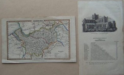
| Books,Maps & Prints of Cheshire |
Images |
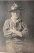
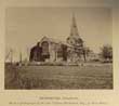
(Code No. 6891).
Dimmock, F. Haydn. (Editor).
Boy Scouts Association World Jamboree.
The Daily Arrowe. Numbers 1 to 14.
Date. July 30th 1929 - August 14th 1929.
Birkenhead. The Birkenhead Advertiser. Folio, [12 x 14 1/2ins]. Pp. (approx) 224 including adverts + illustrations throughout regarding the Boy Scout World Jamboree, held at Arrow Park, Birkenhead. Original boards, detached. The 3rd World Scout Jamboree was held in 1929 at Arrowe Park in Upton, Merseyside, United Kingdom. As it was commemorating the 21st birthday of the Scouting movement, it is also known as the Coming of Age Jamboree. With about 30,000 Scouts and over 300,000 visitors attending, this jamboree was the largest jamboree so far.... £60.00 |
Click on picture above to view more images
How to order |
(Code No. 6873)
Shaw, Sarah.
Silk embroidered map sampler of the County of Cheshire.
Date. 1832.
Wheelock, Cheshire, UK. (approx) size (26 x 22ins). Original silk embroidered map sampler of the County of Cheshire by Sarah Shaw..Framed & glazed. Decorated floral border and title area. Showing explanation: - Market towns, great roads, cross roads, gentleman's residents, Canals etc. References to the Hundreds; - Wirral, Eddisbury, Macclesfield, Bucklow, Northwick, Broxton and Nantwich. Compass and Scale indicators. Slight ware on earlier folds. Not examined outside of frame. Exceedingly rare......... £500.00 |
Click on picture above to view more images
How to order |
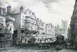
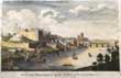
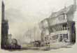
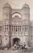
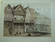
(Code No. 6828)
Pickering, George.
(Antique Print).
Bridge Street, (Chester, UK).
Date. [c.1829].
Printed in London & Chester. Published by J. Seacome, Chester. Page size [15 x 8ins]. Image size, [10 x 6 3/4ins]. . An original lithograph, sketched from nature & drawn on stone by Haghe. Rare print....... £50.00 |
Click on picture above to view more images
How to order |
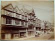
(Code No. 6826)
Griffith, Moses. (artist).
Rows in Bridge Street, Chester. (UK).
Date. 1781.
London. Benj, White. Page size [11 x 9 1/2ins] Image size [8 x 6ins]. .. Original copper engraving by Marell, taken from an original sketch by Moses Griffith..
Moses Griffiths (1749 -1819) was a Welsh draughtsman, engraver and water colourist, he was born 6 April 1749 at Trygain House in the parish of Bryn Groer in Lleyn, Caernarvonshire. His parents were of humble station, and he received a very elementary education but, being clever with his pencil, he was taken into service by Thomas Pennant about 1769. Pennant helped him to study drawing and engraving, and Griffiths became his constant companion on his tours and excursions, making the drawings and engravings for Pennant's numerous works. Griffiths became proficient both as a draughtsman and as an engraver......£40.00 |

Click on picture above to view more images
How to order |
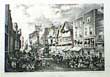
(Code No. 6824)
Pickering, George.
(Antique Print).
Eastgate Street (Chester, UK).
Date. 1829.
Printed in London & Chester by Englemann, Graf, Coindet & Co. Published by J. Seacome, Chester. Page size [15 x 11ins]. by Poole & Harding, Chester. Image size, [10 1/4 x 7ins].
An original lithograph, sketched from nature & drawn on stone by G. Pickering. Showing a view of market day. Rare print...... £50.00 |
Click on picture above to view more images
How to order |
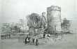
(Code No. 6822)
PROUT, JOHN SKINNER (1805-1876), artist.
(Antique Print).
The Water Tower, Chester. (UK.)
Date. 1839.
London: Ackermann & Co. Chester: Boult & Catherall, Page size (approx) [12 x 9ins.]. . Original lithographic print, nicks to outer margins not affecting image..
Prout acquired some knowledge of lithography and was largely self-trained as an artist. He spent much time in the west of England making topographical views of ancient monuments and in 1838 his "The Castles and Abbeys of Monmouthshire" was published in London. He visited the Wye valley and sketched the antiquities of Chester. . ........ £30.00 |
Click on picture above to view more images
How to order |
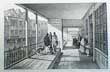
(Code No. 6823).
Tasker, W.
(Antique print of Chester).
Bridge Street Row, Chester. (UK).
Date. 1839.
Chester, John Seacome & Day and Haghe Lithographers to the Queen. Size of page [15 x 11ins].... Original lithographic print by G. Hawkins.taken from an original drawing by William Tasker.
William Tasker. was appointed drawing master at the Chester Mechanics'' Institute. Richard Congreve of Burton in the Wirral then hired him as drawing master to the Congreve Family. He was afterwards employed by Messrs. Evans and Ducker to make drawings of the principal Chester streets. ....... £40.00 |
Click on picture above to view more images
How to order |
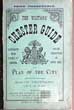
(Code No. 6821)
The Visitors' Chester Guide, and Plan of the City. Illustrated with views of Chester. With a concise description of Eaton Hall.
Date. 1887.
Chester. William Henry Evans. 8vo [5 x 7 1/2ins] . Pp. 32 + Folding Chester town plan. Original decorated covers. Very few 19th century Chester town guides have survived in good condition....... £25.00 |
Click on picture above to view more images
How to order |
(Code No. 6798)
Burlington. Charles.
South Prospect of the City of CHESTER.
Date. 1779.
London. Page size 14 1/4 x 8 3/4 ins. Original copper hand-coloured engraved print, slight marginal cockling.
Showing :- The old Chester Castle before the neoclassical buildings designed by Thomas Harrison, the gatehouse, Saint John's Church before the tower collapsed in the 1880s destroying the western bays of the nave, and The Roman walls, etc. Guaranteed to be over 200 years old. .....£35.00 |
Click on picture above to view more images
How to order |
(Code No. 6777)
BEAMONT, WILLIAM.
An Account of the Ancient Town of Frodsham, in Cheshire.
Date. 1881.
Warrington, Percival Pearse. 8vo [6 x 9ins]. Pp. 272, slight hole to title and slight marks to text. Owner's name to fly leaf. Quarter morocco leather gilt, rubbed.
The Frodsham is of Saxon origin; its 11th century church is mentioned in the Domesday Book. Frodsham was an important manor of the medieval Earls of Chester and was created a borough in the early 13th century, probably by Earl Ranulf III. The mouth of the River Weaver, where it joins the Mersey, made Frodsham into a significant port for the coasting trade, particularly for the export of Cheshire salt, brought down the river from Northwich and Nantwich. The site of the manor house was in Castle Park; the building was of stone and was fortified. ......£50.00 |

Click on picture above to view more images
How to order |
(Code No. 6766)
Ingham. Alfred.
CHESHIRE, Its Traditions & History; including a Record of the Rise and Progress of Freemasonry in this Ancient Province.
Date. 1920.
Edinburgh. Pillans & Wilson. 4to. [9 x 11 1/2ins]. Pp viii, 370. Owner's name on front & rear past down. Illustrated throughout. Original cloth gilt, vg. No D/j....... £25.00 |
Click on picture above to view more images
How to order |
(Code No. 6755)
Windle, B.C.A.
CHESTER: A HISTORICAL TOPOGRAPHICAL ACCOUNT OF THE CITY.
Date. 1903 1st edn.
London : Published by Methuen & Co. 8vo, [8 x 5 1/2ins]. Pp. xvi, 286, [40 adverts] + illustrations throughout. Illustrated by E.H. New. Original gilt decorated cloth. Owner's name on front past down. slight spine fading. Holding firm....... £35.00 |
Click on picture above to view more images
How to order |
(Code No. 6749)
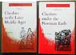
Driver, J.E. & B.M.C. Husain.
2 Volumes.
Volumes 4 & 6.
(History of Cheshire Series). Cheshire in the Later Middle Ages,signed by author and Cheshire under the Norman Earls.
Date. 1971,1973.
Chester, Cheshire Community Council. 8vo, [6 x 9ins].. Pp.142,168 + Illustrations throughout, Original cloth gilt. Dust jackets .very good condition.
volume 4 with owner's signature on front past down.... £30.00 |
Click on picture above to view more images
How to order |
(Code No. 6748)
Tigwell, Rosalind. E, Scard. Geoffrey and Joan Beck.
3 Volumes.
(History of Cheshire Series).
Cheshire in the Twentieth Century - Squire and Tenant: Rural Life in Cheshire 1760-1900 & Tudor Cheshire.
Date. 1968, 1981 and 1985.
Chester, Cheshire Community Council. 8vo, [6 x 9ins]. Volumes 7,10 & 12. Pp.151,99, 111 + Illustrations throughout, Original cloth gilt. 2 Dust jackets as new. Tudor Cheshire's dust jacket with 2 slight nicks..... £30.00 |
Click on picture above to view more images
How to order |
(Code No. 6745)
Budden, Charles W.
Rambles Round the Old Churches of Wirral.
Date. 1922.
Liverpool, Edward Hopwell Ltd.. 8vo, [5 1/4 x 7 1/2ins].Pp..xx, 260. With an introduction by Rev Canon Brook Gwynne + Illustrations throughout of Wirral Churches and their Architecture, Furniture and Customs. Churches listed:- Heswall, Neston, Eastham, Burton, Bidston, Birkenhead, Bebington, Backford, Shotwick, Stoak,Thurstaston, Wallasey, West Kirby, Woodchurch etc. Original cloth gilt, rub marks. No dust jacket.... £45.00 |
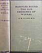
Click on picture above to view more images
How to order |
(Code No. 6744)YOUNG, Harold Edgar.A Perambulation of the Hundred of Wirral in the County of Chester.Date. 1909.Liverpool, Henry Young & Sons. 8vo, [6 x 9ins.] Pp. xix, 220. slight foxing spots to title. Illustrated throughout + folding Map, very good. Top edge gilt, Edges untrimmed. Original cloth gilt........
|
SOLD.
|
|
(Code No. 6697)
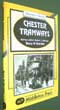
Marsden, Barry M.
Chester Tramways.
Date. 2007
Middleton Press, West Sussex. 4to, [7 x 9 1/2ins]. Pp. 96. including illustrations throughout. Coloured decorated boards. very good condition.
Chester Corporation Tramways operated a tramway service in Chester between 1903 and 1930. Route length 3.58 miles. Under the Chester Corporation Act of 1901, the council took up its option to purchase the assets of the Chester Tramways Company which had been providing horse drawn tramcar services since 1879. It did this for a cost of £18,000.The system was rebuilt to the narrow gauge of 3'6", and 12 new tramcars were ordered from G.F. Milnes & Co. In 1907 the service was enhanced with 5 new tramcars from the United Electric Car Company of Preston......£30.00
|
Click on picture above to view more images
How to order
|
|
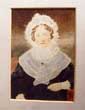
(Code No. 6696)
Victorian photograph of Jane Powell.
Date. [c.1850].
Liverpool. Photograph by Vandyke. Frame size [ [7 x 9ins]. image size 3 1/2 x 5ins. Original photograph with contemporary hand colouring in plain mount, margins marked.
Showing on back of image in a contemporary hand ink title "Jane Powell born 1763 at Holt (UK). Married Thomas Davies 1808 died 1840". £60.00.
|
Click on picture above to view more images
How to order
|
|
(Code No. 6680)The Strangers' Guide through Birkenhead.Date. 1847. Ex Library, no library stamps to text or plan.Birkenhead : Law & Pinkney. 12mo, [7 x 5ins]. Pp. 65. [12] + Large folding map showing:- "Plan of the principal districts of Birkenhead shewing the Docks, Warehouses and Park"...Quarter morocco gilt.......
|
SOLD.
|
|
(Code No. 6658)
Baines, Thomas; Fairbairn, William.
Lancashire and Cheshire Past and Present.
A History and Description of the Palatine Counties of Lancaster and Chester. Forming the North-Western Division of England,,
Volumes 2 & 3 of 4 volumes.
Date. [c.1865].
London: William Mackenzie 4to, [10 x 12ins] Pp. 352 to 464. cclx. 352. Including the rise and progress of manufactures and commerce and civil and mechanical engineering in these districts by William Fairbairn + 13 Steel engraved plates, foxing, mostly marginal.. Original gilt decorated cloth. all edges gilt. Heavy books...... £55.00
|
Click on picture above to view more images
How to order
|
|
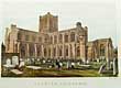
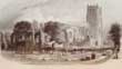
(Code No. 6656)
Rawlins, T. J.
(Antique Print).
CHESTER CATHEDRAL.
Date. [c.1850].
Chester: Published by T Catherall, East Gate Street. Page size, [15 x 11ins]. Image size [11 x 7 1/4ins], . Original hand-coloured lithography engraved by L' Enfant, very good condition. Showing Chester Cathedral before the Victorian improvements...... £35.00
|
Click on picture above to view more images
How to order
|
|
(Code No. 6583)Earwaker, J. P. (John Parsons), 1847-1895.The recent discoveries of Roman remains found in repairing the north wall of the city of Chester.(A series of papers read before the Chester archaeological and historic society, etc., and reprinted by permission of the council.)Date. 1888.Manchester, Published by A. Ireland & Co. 4to, [ 6 1/2 x 10 1/4ins]. Pp. xviii, 175 + 23 Plates some folding Original cloth gilt , very good condition.John. Parsons Earwaker, became interested in history and antiquarian studies, and studied ancient English manuscripts. He was elected honorary secretary of the Oxford Archaeological Society, and acted as deputy-keeper of the Ashmolean Museum . In January 1873 he was elected Fellow of the Society of Antiquaries of London.........
|
SOLD.
|
|
(Code No. 6578)
Chester Scrap Album, UK.
Date. 1790 to 1900.
Chester. 8vo, [5 1/2 x 8 3/4ins].. 17 Photographs, a few damaged + 29 Prints of Chester, UK, some images have worked loose + Folding plan of Chester Castle, tape marked + Hand written & printed historical notes. Half morocco gilt, rubbed..... £45.00
|
Click on picture above to view more images
How to order
|
|
(Code No. 6570)
Egerton Leigh, (Ed).
Ballads & legends of Cheshire.
Date. 1867.
London: Longmans & Co. 8vo, [6 x 8ins]. Pp. xviii, [1], 314 + [14] leaves of plates, slight spots. Original cloth gilt, Split hinges, marked & faded. Holding firm........£45.00
|
Click on picture above to view more images
How to order
|
|
(Code No. 6568)
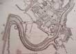
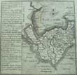
Stockdale, J.
Map of the Canal from Manchester to Runcorn.
(Antique Map).
Date. May 20th 1795.
London. I, Stockdale. Page size [9 x 11 1/4ins]. . Copper engraved canal plan by L. Mutlow. Separate line scale and title. Area shown - River Mersey, Warrington, Runcorn, Manchester, Lymm...... £35.00
|
Click on picture above to view more images
How to order
|
|
(Code No. 6558)
Kelly's Directory of Cheshire.
Date. 1914.
London: Kelly's Directories Ltd. 4to, [7 x 10 1/2ins]. 1914. Pp. xv, 1684, [22 adverts] + Large folding coloured map of Cheshire, drawn and engraved by Kelly's Directories Ltd.
Directory of Cheshire, listing towns, villages with their history including thousands of names, trades and addresses of the inhabitants, from the Accountants to the Woollen drapers. Original cloth gilt, faded...... £75.00
|
Click on picture above to view more images
How to order
|
|
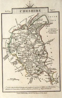
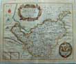
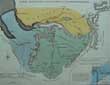
(Code No. 6553)
Archer, J.
(Antique map of Cheshire).
CHESHIRE.
Date. 1832.
London, James Gilbert. Page size, [10 1/2 x 8ins].
Peculiar looking engraved map, the groundwork being black and the detail white. It shows towns, villages, hundreds, canals, rivers and roads. Coat of arms, the title in a lozenge with the imprint above and the engraver's name below, and below the scale.The border is formed by a thick and a thin line with a double inner line marked off into degrees and minutes of latitude and longitude. To the right, i.e. the top of the 4to page, left, " 1832 "; centre, " Guide to Knowledge "......£40.00
|
Click on picture above to view more images
How to order
|
|
(Code No. 6545)THOMPSON, Isaac Cooke.British Association, Liverpool, 1896. Excursion Guide Book. Written by leaders of the excursions and others. Edited by Isaac C. Thompson ... With map, etc.Date. 1896.Liverpool, Philip Son and Nephew. 12mo, [4 1/2 x 6 3/4ins].. Pp. vi, 96 + Folding Map. Excursion September 19th 1896 to October 1st 1896.Visiting Liverpool Overhead Railway, Speke Hall, Storeton Submarine Forest, Bidston Observatory, Chester, Railway Works at Horwich, Manchester Ship Canal, Weaver Navigation, Crewe Railway Works, Vyrnwy water works, English Lakes, etc. Original cloth gilt....
|
SOLD.
|
|
(Code No. 6540)Gamlin, Hilda.Memories or The Chronicles of Birkenhead. The Scenes and People of its Early Days.Date. 1892.Liverpool. Edward Howell. 8vo, [5 x 7 1/2ins.] Pp. viii, 106, [ 33 pages of Birkenhead trade adverts} + 8 illustrations. Owner's signature on front free end paper. Original cloth gilt, slight fading.Hilda Gamlin, a local authoress and historian and wife of a Birkenhead alderman, was born in 1844. Her first book was about Emma, Lady Hamilton, followed by "Memories of Birkenhead". In 1897 she wrote her most famous local history book "Twixt Mersey and Dee". This contains detailed descriptions of Hoylake, West Kirby and Wirral in the 1800's......
|
SOLD.
|
|
(Code No. 6516)SULLEY, Philip.History of Ancient and Modern Birkenhead.Date. 1907.Liverpool: W. M. Murphy. 8vo, [7 x 8 1/2ins]. Pp. 352, [4] + Including portrait frontis & text illustrations. Original cloth gilt, slight rubbing.....Birkenhead is a town within the Metropolitan Borough of Wirral in Merseyside, England. Historically in Cheshire, it is on the Wirral Peninsula, along the west bank of the River Mersey, opposite the city of Liverpool. At the 2001 Census, the town had a population of 83,729. By the time of the 2011 census Birkenhead had become an electoral ward of the Local Authority called Birkenhead and Tranmere. The total population of this ward taken at the 2011 Census was 15,879. Birkenhead is perhaps best known as a centre for ship building, as a seaport and its related industries..... Very Rare. ......
|
SOLD.
|
|
(Code No. 6499)
Cox, Thomas and Robert Morden..
A Topographical, Ecclesiastical, and Natural History of CHESHIRE.
Date. 1700.
London, M. Nutt, Savoy. 8vo. [7 1/4 x 9 1/4ins]. Pp. 273 to 304, mark to outer edges + Copper engraved map of Cheshire by Robert Morden. Original half morocco gilt, split to back leather hinge. Holding firm.
The work, usually attributed to Thomas Cox, was first published in monthly numbers and was afterwards collected into 6 vols., of which the 1st and 2nd came out in 1720 and the remaining 4 vols. from 1724 to 1731. The first two were published for M. Nutt and J. Morphew, but the succeeding ones were for T. Cox...... £65.00
|

Click on picture above to view more images
How to order
|
|
(Code No. 6486)Roberts, Hugh.( Antique Town Plan).New Illustrated Plan of the Ancient City of CHESTER.Date. [c.1850].Chester, Evans & Gresty. Page Size [20 1/2 x 15 1/2 ins] folding to [6 1/2 x 4 1/2ins]. Original lithographic folding plan of CHESTER with 29 marginal vignettes views......
|
SOLD.
|
|
(Code No. 6485)
Trevor, John.
Panorama of the City of Chester; containing its Curiosities, Antiquities and Ancient and Present State; with a visit to Eaton Hall; intended as a Pocket Directory.
Date. 1843, 2nd edn.
Chester. Edward Parry.. 12mo, [4 x 6ins]. Pp [9] 172, foxing, Lacks map of Chester + 15 Engraved prints of Chester + Text prints throughout, (plate listing erratic), marks throughout. Original cloth gilt, splits to cloth......£35.00
|
Click on picture above to view more images
How to order
|
|
(Code No. 6484)
Hanshall, J. H.
History of Cheshire by J. H. Hanshall.
Date. 1817 and 1823.
Chester : Printed by John Fletcher & sold by the author. 4to, [9 x 11ins].Pp.viii-xvi, 663 .Lacks all before pp. vii. 23 Full page copper engraved prints + Text prints throughout, foxing throughout. Half calf gilt, boards detached. Sold as a collection of prints. Rare...... £120.00
|
Click on picture above to view more images
How to order
|
|
(Code No. 6475)
Ormerod, George, 1785-1873.
(Edisbury section only).
The History of the County Palatine and City of Chester .. compiled ..Cheshire antiquaries....survey of every township in the county; incorporated with a republication of King's Vale royal and Leycester's Cheshire antiquities.
Date. 1819.
London: Lackington, Hughes. Large folio. (Edisbury section only).. Pp. 1 to 184 + One copper engraved hand-coloured plate only, (Delamere forest), split into engraved area no loss + Text illustrations throughout, few pages slightly foxed. No covers.
Areas Listed:- Ince, Thornton, Elton, Hapsford, Frodsham, Helesby, Kingsley, Manley, Delamere, Weverham, Vale Royal, Darnhall, Northwich, Budworth, Middlewich, Tarporley, Utkinton, Bunbury, Beeston, Wardle, Peckforton, Tarvin, Mouldsworth, and many other villages, etc.
Much of Ormerod's research was from documents held in Chester Castle and from books and documents lent to him by Hugh Cholmondeley, Dean of Chester. He also borrowed material from some of the leading county families. Much of the transcription of these records was performed by Rev. J. Eaton, his research assistant, and by Faithful Thomas, the deputy keeper of the records at Chester Castle. Ormerod made tours of the county and claimed to have visited each township at least once......£55.00
|
Click on picture above to view more images
How to order
|
|
(Code No. 6472)
NEILSON, Harry B.
" Auld-Lang-Syne" Recollections and Rural Records of Old Claughton, Birkenhead and Bidston with other Reminiscences
Date. 1935.
Birkenhead: Willmer Brothers. 4to, [6 1/2 x 10ins]. Pp. [8], 296 + illustrations throughout. Original cloth gilt. No dust jacket...... £35.00
|

Click on picture above to view more images
How to order
|
|
(Code No. 6470)Leycester. Peter.Historical Antiquities in two Books; the first treating ... of Great-Brettain and Ireland; the second containing particular remarks concerning Cheshire. ... Wherunto is annexed a transcript of Doomsday-Book, so far as it concerneth Cheshire.Date. 1673 1st edn. London. Robert Clavell. Folio [9 x 13.5ins].Title page in red and black + Dedication + To the Reader pp. (6) + Text pp. 7-437, Lacks map + Preface pp. (1) + Lists of Cheshire families with their coats of arms, bottom left corners water stained.. Original full calf gilt, raised spine bands gilt, rubbed with some wear. Hinge leather split, holding firm...Sir Peter Leycester, (1614 -1678) was an English antiquarian and historian. He was involved in the English Civil War on the royalist side and was subsequently made a baronet. He later compiled one of the earliest histories of Cheshire "Historical Antiquities" He developed a library in his home at Tabley Old Hall and made improvements to the house and estate.......
|
SOLD.
|
|
(Code No. 6466)HOWSON, J. S.THE RIVER DEE. Its Aspect and History.Date. 1875 1st edn.London. Virtue. 4to, [8 1/2 x 11 1/4ins] . Pp xiv 174, slight foxing throughout. Illustrated throughout. Original gilt decorated full morocco. Raised spine bands with gilt decorated panels, rubbed. Bevelled & gilt edges.John Saul Howson, was the author of several topographical and archeological works, such as the 'Ecclesiastical Antiquities of Argyllshire' in the 'Transactions' of the Cambridge Camden Society; 'Chester as it was,' 1872; and a historical and architectural guide to his own Chester Cathedral. He also published some devotional books and many separate sermons.......
|
SOLD.
|
|
(Code No. 6463)
Anno Regni Georgii II.
Regis Magnae Britanniae, Franciae & Hiberniae....
An Act to recover & preserve the Navigation of the River Dee, in Cheshire.
Date. 1733-73.
London, Printed by John Baskett. 12mo, [4 x 6 1/4 ins]. Pp. 72, 35, 87, 19, By-Laws, Orders and Rules, [25, index], prelims water stained.
In 1732 a new River Dee Act was passed, vesting all the lands of the estuary from Chester to the sea and the levying of tolls on shipping tonnage, Kinderley was engaged to maintain a depth of sixteen feet of water in the new artificial channel from the sea to Chester on a moderate spring tide. The lay-out of the new channel took a sharp bend from the old river course at Brewer's Hall, Chester to Saltney, followed by a further slight bend and thence in a straight line to Connah's Quay, in all, a distance of nearly eight miles skirting the Flintshire shore. Through the marsh, a trench, eighty feet wide by eight feet deep was excavated and the spoil material was thrown up to form the right or north main bank of the channel. The Act provided for the maintenance of two ferries-the Upper Ferry at Saltney and the lower Ferry (now Queen's Ferry) which was to be supplied with boats at the expense of the Company at all states of the tide. The Lower Ferry was adapted for the transport of horses. The capital of this scheme was £ 62,000. No dividend was paid until 1770. Modern cloth covers....... £100.00
|
Click on picture above to view more images
How to order
|
|
(Code No. 6460)
Pennant, Thomas.
A Tour in Wales.
Date. 1779.
Dublin, Sleater Potts. 8vo, [5 1/2 x 8 3/4ins]. Pp. v, 455, [8], titlepage marked + 3 loose steel engraved prints, (19th century). Modern full morocco gilt.
Thomas Pennant visited Scotland and many other parts of Britain and wrote about them. Many of his travels took him to places that were little known to the British public. Each tour started at his home and related in detail the route, the scenery, the habits and activities of the people he met, their customs and superstitions and the wildlife, etc. This work is the Dublin pirate edition...... £75.00
|
Click on picture above to view more images
How to order
|
|
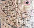
(Code No. 6452)Lister, J.(Antique map).Plan of the Township of Birkenhead and Claughton in the County of Chester. Particularly showing all the New Streets set out by J. Lister.Date. October, 1842.London, C.F. Cheffins. 8vo, [9 x 5 1/2ins] folding out to [37 1/2 x 25 1/2 ins]. Original hand coloured, mounted on linen, lithographic engravedmap, slight spots, dissected into 21 sections. Showing: - Houses and named owners, Hamilton Square, and waterfront, etc. Full morocco gilt, leather loss to spine. Very rare......
|
SOLD.
|
|
(Code No. 6449)
Anon.
(Antique Town Plan).
Plan de CHESTER a 187 miles Nord Ouest de London. Cest iey quon s'embarque pour l Ireland.
Date. [c.1790].
France, Page size [11 1/2 x 8 1/2ins]. Image size [7 1/4 x 5ins]. Original copper engraved town Plan of CHESTER, UK, one foxing spot. Rare print...... £50.00
|
Click on picture above to view more images
How to order
|
|
(Code No. 6446)
PARKER, John Henry.
The Medieval Architecture of Chester. With an Historical Introduction by the Rev. Francis Grosvenor.
Date. 1858.
Chester: Hugh Roberts. Catherall & Pritchard. 8vo, [6 x 9ins]. Pp. 40 + 10 Steel engraved plates + 16 Text plates on wood + Fold out plan. Original cloth gilt, slight hinge cloth split...... £35.00
|
Click on picture above to view more images
How to order
|
|
(Code No. 6442)KING, Daniel of Chester.The Vale-Royal of England or, The County Palatine of Chester Illustrated. Wherein is contained a Geographical and Historical Description of that Famous County.Date. 1656.London, printed by John Streater. Folio, [7 1/2 x 11ins]. Pp. [8], 239, [9] + 3 loose copper engraved plates of 18 plates + 3 Copper engraved text vignette plates, Full calf gilt. Raised spine bands gilt. Sold as an Incomplete copy only.....Daniel King was apprenticed on 3 Sept 1630 as painter for ten years to Randle Holme. After carrying on business for some years at Chester, he removed to London, where in 1656 he published "The Vale Royall of England", This was written by William Smith, William Webb, and Samuel Lee, with an appendix on the Isle of Man by James Chaloner. The dedication is by King. The engravings to the 'Vale Royall' are admirably done by King and Wenceslaus Hollar.......
|
SOLD.
|
|
(Code No. 6440)
King, Daniel and Thomas Hughes.
The Vale Royal of England, or, the County Palatine of Chester illustrated.
Date. 1852.
London, John Gray Bell. 8vo, [ 5 x 7 1/4ins] Pp. 165 + 6 Full page engraved plates + Map + Text illustrations. Half calf gilt over marbled boards, very good condition....... £50.00
|
Click on picture above to view more images
How to order
|
|
(Code No. 6434)
Pennant, Thomas, 1726-1798.
Journey from Chester to London.
Date. 1811.
London. Wilkie and Robinson... 4to, 6 1/4 x 9 3/4ins. Pp viii, 622 + 6 copper engraved plates, slight foxing & off setting on to text. Full calf gilt. Raised spine bands, slight rubbing. Marbled edges.
Thomas Pennant's son David edited this work. Thomas Pennant was a prolific writer specialising in travel and natural history, one of his most popular works on travel was his tour to Scotland in 1769. The correspondence he received from Gilbert White was the basis for White's book "The Natural History and Antiquities of Selborne". Unfortunately Pennant's letters to White have been lost.....£110.00
|

Click on picture above to view more images
How to order
|
|
(Code No. 6424)INDENTURE regarding the disposal of a parcel of land for Mottram in Longdale in the County Chester.Date. 1st January, 1789.England, Mottram. Sizes, (Approx), (27 x 35ins) folding to, approx, (9 1/2 x 8ins). Hand written leave in a beautiful copper plate style on vellum parchment with elaborate initial lettering regarding the disposal of a parcel of land + hand-coloured ground plan.Royal stamp and signatories, Wilbraham Tollemache and Samuel Cooke......
|
SOLD.
|
|
(Code No. 6421)
Ellis J.
(Antique Map).
Map of CHESHIRE. Drawn from the latest Surveys.
Date. 1768.
.... London; Printed for Carington Bowles. Image size,[ 9 1/2 x 7 1/2ins]. Original hand-coloured copper engraved map. Engraved by and under the directions of J. Ellis. (modern colour).
The maps are a close copy of that by Kitchin in "England Illustrated" in 1764, and shows the same details together with the same distortion and the error of longitude. The title cartouches have a background of trees, etc. Top right, outside the border, is the plate number below the bottom border, is the publisher’s imprint. The backs are plain..... £60.00
|
Click on picture above to view more images
How to order
|
|
(Code No. 6409)Lysons. Daniel & Samuel.Magna Britannia, of Great Britain. CHESHIRE.Volume 2, Part 2.Date. 1810.London. T. Cadwell & W. Davis. 4to [9 x 11 1/2ins]..Pp. [1] 297 to 889, [2] + 35 Copper engraved plates, (as listed), fine condition.Lyson's Magna Britannia was published between 1806 -22 in 6 volumes, the intention was to write the history of every county in England, about 10 counties were completed. Cheshire being one of them. Original full calf gilt. Later spine with raised spine bands and gilt decorated panels, rubbed.& slight marks.....
|
SOLD.
|
|
(Code No. 6401)
Kitchin, T.
CHESHIRE, Drawn from the best surveys, maps, charts etc, and regulated ..... by T. Kitchin
(Antique Map).
Date. [c.1784].
London: Printed for R. and J. Dodsley. Image size, [8 1/2 x 6ins].. Original copper engraved map.
The map show towns, principal villages, hills, forests, meres, sands, rivers and roads. Top left centre, an explanation of the symbols on the map, the title with an ornamental surround, A circular compass indicator. The border is formed by a single line with a double inner line marked off into degrees and minutes of latitude and longitude. (Guaranteed to be over 200 years old.)....... £45.00
|
Click on picture above to view more images
How to order
|
|
(Code No. 6398)Delves-Broughton, Louis..(1857–1914).Records of an Old Cheshire Family: A History of the Lords of the Manors of Delves Near Uttoxeter in the County of Stafford and Doddington in the County of Chester..Date. 1908, Signed limited edition. No 42 of 50 copies for sale.London, Arnold Fairbairns & Company. 4to, 9 1/2 x 12ins].. Pp. xvi, 110 + Illustrations throughout. Original cloth gilt, slight marks.The family seat is Doddington Park, near Nantwich, Cheshire. It remains in the family of Sir Evelyn Delves Broughton.....
|
SOLD.
|
|
(Code No. 6397)
Pettitt.
Album of Views of London & Chester.
Date. [c.1890].
London, Pettitt. Oblong folio, [15 x 10 1/4ins]. 30 Photographic type views of London + 30 Photographic type views of Chester, UK + 2 others, including a panorama of the Thames, (Houses of Parliament to the Royal Hotel). Street scenes, public buildings, etc. Original half morocco gilt, rubbed & chipping to top and bottom of spine...... £65.00
|
Click on picture above to view more images
How to order
|
|
(Code No. 6394)
Mortimer, William Williams.
The History of the Hundred of WIRRAL, with a sketch of the City and County of Chester, Compiled from the Earliest Authentic Records.
Date. 1847.
London & Birkenhead, Whittaker and Co. 4to, [9 x 12 ins]. . Pp xvii (6) 440, 36, very good, some pages unopened/unread + Folding lithographic map of the Wirral, + Folding table + 10 lithographic engraved plates, very good. Original trade boards, slight surface loss and slight split to hinges.... £100.00
|
Click on picture above to view more images
How to order
|
|
(Code No. 6386)
Irvine, William Ferguson.
Notes On the Parish Churches of Wirral.
Date. 1896.
Liverpool, Henry Young & Sons. 8vo, [6 x 9 1/2ins]. Pp. 32 including frontis. Listed, Wallasey, Bidston, Overchurch, Woodchurch, Bebington, Eastham, Backford, Stoke, Shotwick, Burton, Neston. Heswall,Thurstaston, West Kirby. Original cloth gilt, slight marks....... £45.00
|
Click on picture above to view more images
How to order
|
|
(Code No. 6385)
Nicholson. Francis. (1753 – 1844).
(Antique print).
Bridge Street, Chester. (UK).
Date. 1821.
Chester, Printed by C. Hullmandle. Page size, [14 x 10ins.] Date. Original lithographic print by Francis Nicholson, very good condition.
Francis Nicholson ( 1753 – 1844) was a British artist. He worked in watercolour and oil, and is mainly known as a landscape artist. He is known as the Father of water colour painting and also as an early pioneer of lithography, and was much admired by Turner...... £75.00
|
Click on picture above to view more images
How to order
|
|
(Code No. 6373)
(Antique Chester Print.)
Nicholson Francis, (1753-1844), Watercolour painter.
At Flookersbrook near Chester.
Date. 1821.
Printed by Rowney & Foster. Page size [10 x 14 ins]. Original lithographic print of Flookersbrook near Chester.
Nicholson was born in Yorkshire in 1753. He worked in watercolour and oil and is mainly known as a landscape artist. He became one of the founders of the Society of Painters in Watercolours. Print is guaranteed to be over 150 years old. .... £60.00
|
Click on picture above to view more images
How to order
|
|
(Code No. 6346)
Blome, Richard.
(Antique Map).
CHESHIRE.
Date. 1673.
London. t. Roycroft. Page size [14 x 12ins]. Image size, [13 x 10ins].. Hand-coloured, (modern hand-colouring), copper engraved map with title and scale in two ornamental cartouches. The panel containing a list of the hundreds and explanatory table for the symbols of the map. A laurel wreath containing the arms of Thomas Cholmondeley surmounting the dedication. Circular compass indicator. Two sail ships approaching the River Mersey........ £160.00
|
Click on picture above to view more images
How to order
|
|
(Code No. 6288)
HALL, Samuel Carter.
(4 Antique Prints).
4 Cheshire Prints.....Adlington Hall, Banquetting Room Bramhall, Drawing Room Lyme Hall, and Brereton Hall..
Date. [c.1850].
London. Page size, (approx), [14 1/2 x 11 ins.]. 4 Lithograph plates of Adlington Hall, Banquetting Room Bramhall, Drawing Room Lyme Hall, Brereton Hall, taken from "The Baronial Halls, and ancient picturesque edifices of England". Slight foxing and marks to blank margins. Guaranteed to be over 150 years old...... £40.00
|
Click on picture above to view more images
How to order
|
|
(Code No. 6242)
Poole, J.
(Antique Print).
A New and Accurate Plan of the City of Chester.
Date. 1st October 1791.
Chester, (UK), J. Poole. Image size, [13 1/2 x 9 1/2ins]. Original copper engraved folding Chester town plan, engraved and drawn by Murray and Stuart of Chester, fold strengthened on the back of print. Rare print...... £75.00
|
Click on picture above to view more images
How to order
|
|
(Code No. 6239)Buckanan, Eliza. Ann.(Watercolour painting).Fishing boats at Parkgate, in the Wirral. (UK).Date. 1879.England, Image size, [9 1/4 x 5ins]. Original watercolour painting of the front at Parkgate by Eliza. Ann Buchanan, foxing. Taken from a sketch book assembled by Sidney Massee "English bathing places, dedicated to a friend In memory of pleasant visits spent together in these places in years gone by".Parkgate was an important port from the start of the eighteenth century, in particular as an embarkation point for Ireland. During the years when the port existed, two distinguished guests stayed in the local hostelries. One was Lord Nelson's mistress, (Lady) Emma Hamilton, who was born in nearby Ness and who used to bathe at Parkgate, for a skin complaint. The other was Handel who stayed in Parkgate before sailing to Dublin in April 1742 for the first performance of the Messiah. He had finished the Messiah in the summer of 1741 and added minor touches to the work in Parkgate .....
|
SOLD.
|
|
(Code No. 6238)Buckanan, Eliza. Ann.Parkgate Front, in the Wirral. (UK).(Watercolour painting).Date. 1879. England, Image size, [9 1/4 x 5ins]. Original watercolour painting of the front at Parkgate by Eliza. Ann Buchanan, foxing. Taken from a sketch book assembled by Sidney Massee "English bathing places, dedicated to a friend In memory of pleasant visits spent together in these places in years gone by".Parkgate was an important port from the start of the eighteenth century, in particular as an embarkation point for Ireland. During the years when the port existed, two distinguished guests stayed in the local hostelries. One was Lord Nelson's mistress, (Lady) Emma Hamilton, who was born in nearby Ness and who used to bathe at Parkgate, for a skin complaint. The other was Handel who stayed in Parkgate before sailing to Dublin in April 1742 for the first performance of the Messiah. He had finished the Messiah in the summer of 1741 and added minor touches to the work in Parkgate .....
|
SOLD.
|
|
(Code No. 6232)
Wood, John George.
The Water Tower at Chester. (UK).
Date 1814.
London, Page size, [10 3/4 x 14 1/4ins].. Original soft ground etching by John George Wood.
The Water Tower (originally known as the New Tower) is a 14th-century tower in Chester, which is attached by a spur wall to Bonewaldesthorne's Tower on the city walls. The tower, together with its spur wall, is designated by English Heritage as a Grade I listed building. The original name of the tower was New Tower but in the 17th century it became known as the Water Tower....£35.00
|

Click on picture above to view more images
How to order
|
|
(Code No. 6231)
Wood, John George.
View at Lynn, (Lymm), Cheshire.
(ANTIQUE PRINT).
Date 1815.
London, Page size, [10 3/4 x 14 1/4ins].. Original soft ground etching by John George Wood. .Soft-ground etching uses a special softer ground. The artist places a piece of paper over the ground and draws on it. The print resembles a drawing....... £35.00
|
Click on picture above to view more images
How to order
|
|
(Code No. 6227)Caton, A.G. & Harold Edgar Young.The Romance of Wirral.Perambulation of the Hundred of Wirral.2 Volumes.Dates. 1949, 4th edn & 1909, third Impression.Liverpool, Philip, Son & Nephew, Ltd & Henry Young & Sons. 8vo,The Romance of Wirral:- Pp. [6], 102 + Folding map + Illustrations throughout. Dedication on front free end paper. Dust jacket with some loss.Perambulation of the Hundred of Wirral:- Pp. xix, 220 + Folding map + Illustrations throughout. Dedication on front free end paper. No dust jacket, rubbed......
|
SOLD.
|
|
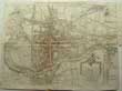
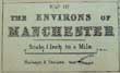
(Code No. 6225)
Map of the Environs of MANCHESTER &
Map of the Environs of LIVERPOOL.
(2 Antique Town Plans).
Date. [c.1875].
London, (George Philip and Son). Page sizes, (approx), [20 x 13ins]. 2 Original engraved Town Plans with hand-colour. Scale iinch to the Mile. ......£40.00
|
Click on picture above to view more images
How to order
|
|
(Code No. 6217)Earwaker, John Parsons, 1847-1895.East Cheshire: Past and Present: Or a History of the Hundred of Macclesfield, in the County Palatine of Chester. From Original Records.Two Volumes.Date. 1877 & 1880.London: Printed for the Author. Folio, [10 1/2 x 13ins]. Pp. xxviii, 510. xxiv, 704, slight foxing to prelims + 2 Full page photographs + 251 Full page plates and text plates throughout. Original gilt decorated cloth, slight rubbing and chipping to top and bottom of spines....John Parsons Earwaker became interested in history and antiquarian studies, and studied ancient English manuscripts. He was elected honorary secretary of the Oxford Archaeological Society, and acted as deputy-keeper of the Ashmolean Museum in 1873-4; In January 1873 he was elected Fellow of the Society of Antiquaries of London. He was one of the founders and honorary secretary of the Record Society of Lancashire and Cheshire, and a member of the councils of the Chetham Society, the Historic Society of Lancashire and Cheshire. Juliet Earwaker, his wife, illustrated his East Cheshire and other works.
|
SOLD.
|
|
(Code No. 6213)
Moss, Fletcher.
Pilgrimages in Cheshire & Shropshire.
Date. 1972 Reprint.
Didsbury, Manchester. E J Morten, 8vo. Pp. xvii, 283 + Illustrations throughout. Dedication on front end paper. Original cloth gilt. No dust jacket. .....£35.00
|

Click on picture above to view more images
How to order
|
|
(Code No. 6212)
Dodgson, John McNeal.
(Part 1 & 2).
2 Volumes.
THE PLACE-NAMES OF CHESHIRE, (Part One): County.. Regional, & Forest Names, River-Names, The Place-Names of Macclesfield Hundres..&...(Part 2)..Bucklow Hundred and Northwich Hundred.
Date. 1970.
Cambridge, Cambridge at the University Press 8vo, Pp. ix,329. xlvi, 338, Dedication on front end paper and a few marginal notes. No Dust jacket. Original cloth gilt, very good condition...... £35.00
|
Click on picture above to view more images
How to order
|
|
(Code No. 6210)Croston, James.Historic sites of Lancashire and Cheshire.A wayfarer's notes in the Palatine counties, historical, legendary, genealogical, and descriptive.Date. 1883.London, Manchester, John Heywood. 8vo, Pp. xxvii, 499, a few corners water stained + Illustrations throughout. Original gilt decorated cloth, slight loss and marked.Of some of the families which have flourished or still flourish in these parts Mr. Croston gives us an account, illustrated and enlivened by many social and historical details. He is a genealogists which disapproves of the imaginary pedigrees to which some of the "Peerages' "give an undeserved authority. He requires proof before he credits his "county families" with a genuine antiquity......
|
SOLD.
|
|
(Code No. 6207)
Tait, James.
The Domesday Survey of Cheshire | With Introduction, Translation and Notes By James Tait.
Date. 1916.
Manchester, Chetham Society. 8vo, [ 7 x 9ins]. Pp. xvi, 258 + Folding map, nicks to edges, no loss. Original cloth gilt. slight marks.
The Domesday survey, following the Norman conquest, recorded the names of the new holders of lands and the assessments on which their tax was to be paid. By the king's instructions, it make a national valuation list, estimating the annual value of all the land in the country...... £45.00
|
Click on picture above to view more images
How to order
|
|
(Code No. 6209)KING, Daniel of Chester.The Vale-Royal of England or, The County Palatine of Chester Illustrated. Wherein is contained a Geographical and Historical Description of that Famous County.Date. 1656.London, printed by John Streater. Folio, [7 1/2 x 11ins]. Pp. Engraved title page, (10), 99, [5], 239, [11], 55, [1], [6], 34 + Total of 18 copper engraved plates including 12 pages of Cheshire families' coats of arms + Folding copper engraved maps of Cheshire & Isle of Man, engraved by Wenceslaus Hollar + Copper engraved plan of Chester + 3 Copper engraved vignette plates, (collation correct), one plate with fold split,(2ins), repaired . Interspersed with blank pages with some hand written Cheshire historical notes in an 18th century hand. Original full calf gilt. Raised spine bands with gilt decorated panels, Hinge leather splits. Holding firm.Daniel King was apprenticed on 3 Sept 1630 as painter for ten years to Randle Holme. After carrying on business for some years at Chester, he removed to London, where in 1656 he published "The Vale Royall of England", This was written by William Smith, William Webb, and Samuel Lee, with an appendix on the Isle of Man by James Chaloner. The dedication is by King. The engravings to the 'Vale Royall' are admirably done by King and Wenceslaus Hollar.......
|
SOLD.
|
|
(Code No. 6198)Ormerod, George, 1785-1873. Revised and enlarged by Thomas Helsby.3 Volumes.The History of the County Palatine and City of Chester .. compiled .. Cheshire antiquaries....survey of every township in the county; incorporated with a republication of King's Vale royal and Leycester's Cheshire antiquities.Date. 1882. 2nd edn.London : George Routledge and Sons. Large folio. Pp. lxxxii, 762, 879, 934 + 63 Copper engraved plates including 4 Hand-coloured, (complete as listed) + 3 Extra illustrated engraved plates including a proof before letters plate of a Chester Street scene. A few plates slightly foxed, other plates fine. Text plates throughout ..Original cloth, slight hinge splits with some loss to printed labels. Holding firm. Very heavy books.Much of Ormerod's research was from documents held in Chester Castle and from books and documents lent to him by Hugh Cholmondeley, Dean of Chester. He also borrowed material from some of the leading county families. Much of the transcription of these records was performed by Rev. J. Eaton, his research assistant, and by Faithful Thomas, the deputy keeper of the records at Chester Castle. Ormerod made tours of the county and claimed to have visited each township at least once.......
|
SOLD.
|
|
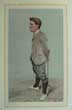
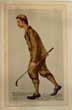
(Code No. 6185)
Original Vanity Fair Print .
(Antique Golf Print).
Hilton, Horace.
Date. July 16th 1903.
H. London. "Vanity Fair" Office. Page size, (approx), [10 1/4 x 14 1/2 ins].Guaranteed original coloured lithograph, engraved by Day & Son from a drawing by Spy. Titled - " Hoylake "
Hilton was born in West Kirby, in the Wirral, and attended West Buckland School in Devon. In 1892, he won The Open Championship at Muirfield, becoming the second amateur to do so. He won again in 1897 at his home club, Royal Liverpool Golf Club, Hoylake. The only other amateurs who have won the Open Championship are John Ball and Bobby Jones........ £130.00
|
Click on picture above to view more images
How to order
|
|
(Code No. 6181)Neele, Samuel John.Plan of CHESTER, (UK).( Antique print).Date. July, 25th 1809.London, Cadell & Davies. Page size [17 x 11 1/2ins]. Original engraved print of the "Town Plan of Chester", slight fold split, repaired. Nicks ot outer edge, not affecting engraved image. Scale, (approx), 1 inch to 1/4 mile. Taken from the Lysons' Magna Britannia, volume 2, Part 2....
|
SOLD.
|
|
(Code No. 6179)
Budden, Charles W.
Old English Churches.
Their Architecture, Furniture and Customs. As Illustrated by the Wirral Peninsula.
Date. 1925.
Liverpool, Cathedral Bookstall. 8vo, [5 1/4 x 8ins]. Pp..xxii, 260. With an introduction by Sir Giles Gilbert Scott + Illustrations throughout of Wirral Churches and their Architecture, Furniture and Customs.
Churches listed:- Heswall, Neston, Eastham, Burton, Bidston, Birkenhead, Bebington, Backford, Shotwick, Stoak,Thurstaston, Wallasey, West Kirby, and Woodchurch. Original cloth gilt. No dust jacket...... £25.00
|
Click on picture above to view more images
How to order
|
|
(Code No. 6136)
Original Vanity Fair Print .
(Antique Golf Print).
John Ball Jr.
Date. March 5th 1892.
London. "Vanity Fair" Office. Page size, (approx), [9 1/4 x 14 1/2 ins]. . Guaranteed original coloured lithograph, engraved by Day & Son from a drawing by Lib. Titled - " John Ball Jr "
Ball was born in Hoylake, Merseyside. His father was the prosperous owner of the Royal Hotel, located near the Royal Liverpool Golf Club. After winning The Amateur Championship in 1888, Ball became the first English-born player to win The Open Championship in 1890, and in the same year won his second Amateur, the first to win both titles in the same year. Ball subsequently won the 1892, 1894, 1899, 1907, 1910, and 1912 Amateurs, a record eight titles in all, in addition to two runner-up finishes. Ball retired with a 99-22 record (81.8%) at the The Amateur Championship. Ball was also runner-up in the 1892 Open........£130.00
|
Click on picture above to view more images
How to order
|
|
(Code No. 6102)"Geographia"Atlas and Guide to Liverpool, Birkenhead, Bootle and Wallasey.Date. [c.1923].London, Geographia Ltd. 8vo, [5 x 7 1/4ins]. [c.1923]. Pp. 55 including index + 64 Coloured sectional maps, very good condition. Listing:- Railways, roads, named streets, parks, administrative map, docks, etc. Original cloth, faded and marked.......
|
SOLD.
|
|
(Code No. 6092)Gardner, Thomas.(Antique Strip Road Map).The Road from Shrewsbury, Chester to Holywell and on to Flint.Date. 1719.London: J. Tonson & J. Watts. Page size, (approx), [11 x 7ins]. Plate no. 98. Original copper engraved strip road map :- Shrewsbury, Wrexham, Holywell, Chester and Flint. Dedicated to John Conway. Taken form Thomas Gardner's "Pocket Guide to The English Traveller" Dedicated to Sir Thomas Conway......
|
SOLD.
|
|
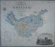
(Code No. 6084)
GREENWOOD, C & J.
(Antique Map).
Map of the County of CHESHIRE,
from an Actual Survey Made in the Years 1819.
Date. 1819.
London, Greenwood & Co. 13 Regents Street Pall Mall. Image size, (approx), [27 x 22 1/2 ins]. Original beautiful hand coloured steel engraved map with a vignette of Chester Cathedral, very good condition....... £85.00
|
Click on picture above to view more images
How to order
|
|
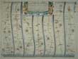
(Code No. 6004)
Ogilby. John.
( Antique Strip Road Map).
The first part of the strip map- The Road from York to West-Chester. From Warrington, Frodsham, Chester.
The second part of the strip map - Manchester, Stockport, Dysley, Deyn, Buxton, Lathkel, Brassington, Weston Underwood ending at Derby.
Date. 1675 - 98.
London. Page size, (approx), [ 20 1/4 x 16 ins ]. Image Size [ 17 x 13ins ]. Original copper engraved Strip Road Map, (modern colouring), very good condition. Each map strip shows towns, villages, mansions with owner's name, castles, wind mills, beacons, gallows, woods, rivers, and hills etc. Elaborate title cartouche and compass roses to each map strip.
John Ogilby was a topographer, printer, and map-maker, born in Edinburgh, EC Scotland, UK. A dancing teacher and theatre owner, he lost everything in the Civil War, but after the Restoration obtained court recognition and became a London publisher. The great fire of 1666 destroyed his stock but got him the job of surveying the gutted sites in the city. He established a thriving printing house and was appointed 'king's cosmographer and geographic printer'. His most important publications were engravings of maps and atlases, including Africa (1670), America (1671), and Asia (1673), and a road atlas "Britannia" (1675), unfinished at his death. He was also the first cartographer to adopt the statute mile. Scale 1inch to the mile, each mile is divided into furlongs indicated by dots in the centre of the road. Guaranteed to be over 300 years old.......£150.00
|
Click on picture above to view more images
How to order
|
|
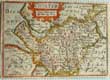
(Code No. 6003)
Keere Van De.
(Antique miniature map).
CHESHIRE.
Date. 1627.
London. Humble. George. Map image size [5 x 3 1/2ins]. Hand-coloured copper engraved miniature map of Cheshire by Van De. Keere, abridged from John Speed's The Theatre of the Empire of Great Britain. Title "Chester" and scale in an ornamental cartouche. Bottom left, the engraver's name. On the back of map paper guard above the printed English text....... £110.00
|
Click on picture above to view more images
How to order
|
|
(Code No. 5976)
HOLLAND, Henry.
General View of the Agriculture of Cheshire;
With Observations Drawn up for the Consideration of the Board of Agriculture and Internal Improvement.
Date. 1808.
London, Richard Phillips. 8vo, [6 x 9ins]. Pp. xii, 375, [3], [2 pp. Catalogue of seeds, etc] + 2 Engraved maps of Cheshire, one hand coloured + 6 Engraved plates, including 2 hand-coloured, (as listed) , very good condition. Original embossed boards, tape marked. Modern spine cloth gilt.
Listing:- Soil types, Draining fields, animal types, cows, Cheshire cheeses, ploughing, crops, harvesting, animal feeds, ect........ £90.00
|
Click on picture above to view more images
How to order
|
|
(Code No. 5974)
Woollard. James.
Woollard's New Large-Scale Cycling & Touring Road-Map of LIVERPOOL and District with Main Roads Specially Coloured.
Date. 1870-80.
Liverpool. James Woollard. Size [35 x 27 ins], folding to [4 1/2 x 7 ins]. Linen backed sectional outline hand coloured ordnance survey map, Slight splits to hinges, strengthened on back.
Showing the whole of the Wirral to Chester, part of Flintshire then Southport east to Charnock Richard. Scale, 1 inch to the Mile. Original cloth boards with paper title on front cover..... £45.00
|
Click on picture above to view more images
How to order
|
|
(Code No. 5900)
Colby, Colenel.
Ordnance Survey.
Sheet Reference: LXXXI NW.
(Cheshire, UK).
Date. 27th March 1842.
London, Ordnance Map Office. Image size, (approx), [13 x 14 1/4ins]. Hand-coloured engraved map, laid on linen. Scale 1" to the statute mile. very good condition.
Showing:- the Alderley, Presbury and Stockport areas also the Liverpool and Manchester Railway line (L&MR) the world's first twin-track inter-city passenger railway in which all the trains were timetabled and ticketed. The line opened on 15 September 1830 and ran between Liverpool and Manchester........ £35.00
|
Click on picture above to view more images
How to order
|
|
(Code No. 5869)
J & P.
(HAND DRAWN ESTATE PLAN).
Plan of Property situate at Little Sutton in the County of Chester, (UK), belonging to Richard Naylor Esquire.
Date. March, 1867.
England. Size, [26 1/4 x 18ins]. Linen backed hand drawn estate plan with outline hand-colour, dust marked. Showing:- roads, inns, railways and numbered fields and their sizes, etc.
Mr. Naylor, a wealthy Liverpool banker bought Hooton Hall and the land for 82,000 guineas from the Stanley family to cover their gambling debts in the 1850's. He then built a racecourse, polo ground, heronry, stud farm and a church in Childer Thornton in memory of his first wife. . To avoid paying rates the hall was emptied of contents and staff in the 1890's but the estate continued to be farmed whilst the racecourse and polo ground remained in use...... £120.00
|
Click on picture above to view more images
How to order
|
|
(Code No. 5855)
Palin. John, (Surveyor)
7 TURNPIKE ROAD MAPS.
" Plans and Sections of the CHESTER, FARNDON, and WORTHENBURY Turnpike Road"
Date. 1853.
Chester. Barker and Hignett, (Solicitors). Elephant folio. (20 x 29 ins), 7 Lithographic maps of plans and sections with original outline hand colour. Engraved by "Evans, Gresty and Dunhill, Lithographers, Chester", some marginal nicks & one split into engraved area, (3ins, repaired). Original linen covers with linen title label to upper cover. Fine calligraphic titles, Compass indicator, "Notes" and 2 Scale Lines, (Chains and Miles, 5 miles to the inch). Road starts at the stone step of the Jolly Gardener Pub, Boughton and ending at Worthenbury, passing through the parishes of Huntington, Aldford, Buerton, Churton, Caldecott. RARE COPY...... £300.00
|

Click on picture above to view more images
How to order
|
|
(Code No. 5841)
Map illustrative of the Situation of the Salt District. (Cheshire, UK).
(Antique Geological Map).
Date. 1811.
London. T. Cadell and W. Davis. Page size [11 x 9ins]. Original hand-coloured steel engraved map of the salt districts of Cheshire, with an inset map of the Rock salt district of Northwich, very good condition.
Rock salt was laid down in this region some 220 million years ago, during the Triassic period. Seawater moved inland from an open sea, creating a chain of shallow salt marshes across what is today the Cheshire basin. As the marshes evaporated, deep deposits of rock salt were formed. Rare Cheshire map....... £80.00
|
Click on picture above to view more images
How to order
|
|
(Code No. 5836)Clayton, Howard.The Duffield Bank and Eaton Railway, (Cheshire, UK).Date. 1965.The Oakwood Press, 8vo, [6 x 9ins]. Pp. 92 + Illustrations throughout. Original cloth gilt. Dust jacket, slight marks.The Eaton Hall Railway was an early 15 in (381 mm) gauge narrow gauge estate railway built in 1896 at Eaton Hall in Cheshire. It was built for the Duke of Westminster by Sir Arthur Percival Heywood, who had pioneered the fifteen inch (381 mm) gauge with his Duffield Bank Railway, and connected the hall to the GWR station sidings at Balderton on their Shrewsbury to Chester Line, some 3 miles (4.8 km) away.......
|
SOLD.
|
|
(Code No. 5822)
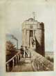
Gresty. John.
(Antique Print of Chester).
King Charles Tower, (Chester. UK.)
Date. [c.1870].
Chester. John Gresty. Page size, [14 x 10 1/2ins.] Image size [11 x 8 1/2ins.]. Original coloured lithographic print, faint foxing spots and nicks to outer edges, not affecting the image. Taken from Gresty's Illustrated Chester. John Gresty had a shop at 29 Eastgate Street and a printing works for letterpress and lithography at 43 Watergate Row. He was in business in 1865 as "Evans & Gresty", publisher. Ref :- History of Printing in Chester.
Standing on the North-East corner of the city walls over looking the canal, is the tower called "King Charles's Tower". On the 24th of September 1645. King Charles stood on the tower and watched his army defeated in the battle of Rowton Moor it was the evening before the Battle of Rowton Moor. The next evening he is said to have watched the battle partly from the Phoenix Tower and partly from the tower of the Cathedral. From which he is said to have nearly been shot by a sniper. The main battle started at 4pm on heath ground 3 miles West of the City called Millers Heath. The battle lasted most of the evening of the 24th with scattered fights between Rowton and the city walls. The Royalists lost the battle with over 2000 killed or captured.....£45.00
|
Click on picture above to view more images
How to order
|
|
(Code No. 5766)
PARKER, John Henry.
The Medieval Architecture of Chester.
With an Historical Introduction by the Rev. Francis Grosvenor.
Date. 1858.
Chester: Hugh Roberts. Catherall & Pritchard. 8vo, [6 x 9ins]. Pp. 40 + 10 Steel engraved plates + 16 Text plates on wood + Fold out plan. Original cloth gilt, lacks part spine cloth..... £35.00
|
Click on picture above to view more images
How to order
|
|
(Code No. 5723)
CARTLIDGE, John Edward Gordon.
Newbold Astbury and its History .
A Descriptive and Historical Account of an Ancient Cheshire Church and Parish. ... By Rev. J. E. G. Cartlidge ... assisted by Henry Barlow ... and Ernest Hitchens. [With plates.]
Date. 1915.
Congleton, Thomas Gordon. 4to, [7 x 10ins]. Pp. xvi. 214 + Illustrations throughout. Original cloth gilt, faded.
Newbold Astbury (often just Astbury) is a village it is situated to the south of Congleton. Despite being much smaller, Astbury is an older settlement than Congleton and the parish originally included Congleton; in those days the land surrounding Astbury was swampy so the inhabitants moved uphill to where Congleton is today and Astbury became isolated. The church was built of millstone grit and the detached spire of the mid-14th century looks to be earlier. Sir Gilbert Scott was responsible for a modest restoration in 1862. Rare copy....... £70.00
|
Click on picture above to view more images
How to order
|
|
(Code No. 5712)Kitchin, T.(Antique Map.)CHESHIRE.Drawn from an best Survey Maps & Charts and regulated by Astron' Observant by T. Kitchen.Date. [c.1795].London, Alex. Hogg. Page size [12 x 8ins]. Image size [9 x 5 1/2 ins]. Hand-coloured copper engraved map by T. Kitchin. From Antiquities of England and Wales by Captain Grose. Guaranteed to be over 200 years old......
|
SOLD.
|
|
(Code No. 5706)
Moule, Thomas.
CHESHIRE.
(Antique Map, Guaranteed over 140 yrs old ).
Date. [1836 -52.]
London. Virtue. Page size 10 3/4 x 8 ins. Original steel engraved county map of CHESHIRE. Decorated with vignettes, view of Eaton Hall and Chester Cathedral. Ornamental border with symbolic figures woven into the design, heraldic coat of arms. Moule's county maps are the last series of decorative maps to be published..... £55.00
|

Click on picture above to view more images
How to order
|
|
(Code No. 5703)
Badeslade, Thomas.
Cheshire.
(Antique Map).
Date. 1741.
London. H. Toms, T. Badeslade. Page Size, [7 x 6 1/2ins]. Image size [5 3/4 x 5 3/4ins].Original copper engraved map. The map shows rivers (very much exaggerated), meres, hills, forests, towns, and bridges. The surrounding country is stippled and the county boundary and coast are shaded, thus throwing the map into relief. A circular compass indicator. The scale, divided from the map by a single line, is a list of the towns and their market-days, etc. The border, which encloses all the above is formed by a double line. Outside the border, at the top, is the. Title and at the bottom, the names of the draughtsman and engraver with imprint and date. The back is plain..... £55.00
|
Click on picture above to view more images
How to order
|
|
(Code No. 5613)Morden, Robert.(Antique Map).The County Palatine of Chester.Date 1695.London, Able Swale. Image size: [16 x 13 1/4 inches]. Original copper engraved map with later colouring, small hand written ink date on map surface.Robert Morden (c.1650-1703) was a British bookseller, publisher, and maker of maps and globes. He was among the first successful commercial map makers. Between about 1675 and his death in 1703, he was based under the sign of the Atlas at premises in Cornhill and New Cheapside, London. His cartographical output was large and varied. His best known maps are those of English counties first published in a new edition of Camden's "Britannia" in 1695, and subsequently reissued in 1722, 1753 and 1772. These maps were based on new information from gentlemen of each county, and were newly engraved. Each map has a decorated cartouche, with numerous place names...
|
SOLD.
|
|
(Code No. 5579)Painted Glass in a Window of Farndon Church Containing Portraits of Cheshire Gentlemen who attended K. Charles I. at the Seige of Chester.Date. 1818.London, Lackington & Co. Page size, [13 1/2 x 7 3/4ins]. Original hand-coloured copper engraved print, very slight mark to fold.From a Drawing contributed by the very Revd. Hugh Cholmondeley Dean of Chester. Hidden away in a secluded part of St.Chad's Church in Farndon, Cheshire is a stained glass window depicting key players and scenes relating to the English Civil War. St. Chad's was damaged during the war. This window was also damaged but restored.....
|
SOLD.
|
|
(Code No. 5569)Gresty, J.Excursionists Guide to Chester and its Vicinity...... with a Sketch of Eaton Hall and Beeston Castle.Date. [c.1870].Chester. J.Gresty. 12mo, [4 3/4 x 7ins]. Pp.16, marginal pencil annotations + Beautiful engraved town plan + Engraved frontis, (Bridge Street), + Text illustrations. Including one page description of Eaton Hall. Original pictorial paper covers, slightly marked....
|
SOLD.
|
|
(Code No. 5565)Grose. Francis,(ANTIQUE MAP)CHESHIRE.Date. [c.1780].London, S. Hooper. Approx page size [7 1/4 x 10 1/2ins].. Original hand-coloured copper engraved map, (modern colouring), with a historical account of the county, at the bottom, and is continued at the back..slight hole above border line.The map is a reprint of John Seller's map dated 1701, from [Camden's Britannia abridged, J. Wild]. Guaranteed to be over 200yrs old.....
|
SOLD.
|
|
(Code No. 5546)
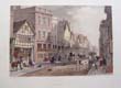
Tasker, W.
(Antique print of Chester).
Watergate Street Chester. (UK).
Date. [c.1830].
Chester, Evans & Ducker. Size of page [13 x 9 1/2ins]. Original hand-coloured, (modern colouring), lithographic print by G. Hawkins.
William Tasker was appointed drawing master at the Chester Mechanics'' Institute. Richard Congreve of Burton in the Wirral then hired him as drawing master to the Congreve Family. He was afterwards employed by Messrs. Evans and Ducker to make drawings of the principal Chester streets...... £40.00
|
Click on picture above to view more images
How to order
|
|
(Code No. 5542)Naftel, Paul. F. (Artist)Old Houses, Watergate Street, Chester. (UK).(Original pencil sketch).Date. 1839.Chester. Size of Image, (approx), [8 x 6ins]. Original pencil sketch by Paul Naftel.Paul Naftel arrived in Chester in the 1830s. While in Chester he taught landscape drawing. After a few months he moved to Jersey. During his short stay in Chester he sketched a few choice examples of old architecture. This sketch is a good example.....
|
SOLD.
|
|
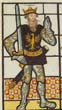
(Code No. 5533)
Fowler, William.
( Antique Print).
Saxon and Norman Earls of Chester, (UK). From ancient painted glass, formerly in a window of Brereton Hall.
Date. 1818.
London, Lackington & Co. Page size, [13 1/2 x 7 3/4ins]. . Original hand-coloured copper engraving, very good.
Brereton Hall, in Cheshire, was built in the reign of Elizabeth, The founder appears to have used stain glass in the decoration of his mansion. In many of the windows were the various bearings of the principal Cheshire families, This original hand-coloured engraving of 1818 is the greatest object of interest in the mansion. It was described and engraved for Ormerod's 'History of Cheshire, 1819..... £60.00
|
Click on picture above to view more images
How to order
|
|
(Code No. 5494)
Bedford, Francis, (1816-1894): and another.
9 Loose Photographs of Old Chester, UK.
Date. 1870-80.
Chester publishers, Catherall and Pritchard. Image sizes 8 3/4 x 6 1/2ins to 5 x 8ins. 9 Loose Albumen photographic print, very good. Not all the images are titled. Listing:- Houses, Street scenes and the Chester rows, etc.
Francis Bedford was an architect, as well as a draughtsman and lithographer. In 1854 he was commissioned by Queen Victoria to photograph objects in the royal collection, and later photographed Prince Albert’s native town of Coburg. He also captured previously unrecorded sites when accompanying the Prince of Wales on a tour of the Holy Land. But Bedford is best known for his numerous views of Great Britain; including views of Wales, Devon, Chester, Warwickshire and Stratford-upon-Avon, as well as a stereoscopic series, "English Scenery".... £110.00
|
Click on picture above to view more images
How to order
|
|
(Code No. 5475)
(Pigott, I.B.M.)
History of the City of Chester, from its foundation to the present time; collected from public records, private manuscripts, and other authentic sources. ....
Date. 1815.
Chester: printed for T. Poole; and sold by Longman, Hurst, Rees, Orme, and Brown; and Walker, London. 8vo, [5 1/2 x 8 3/4 ins]. Pp. [4], iii, [1], 334, ii + 5 Etched plates, ( A small etched view of the Rows is printed on the title-page and evidently counts as one of the five unnumbered etchings by George Cuitt). Original trade boards, slight marks.... £95.00
|
Click on picture above to view more images
How to order
|
|
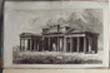
(Code No. 5433)Campbell, Colen.(Antique Print.)The Front of Eaton Hall in Cheshire, the Seat of Lord Grosvenor.Date. 1715-25.London, Page size [11 x 8 1/4ins].. Original copper engraved plate by H. Hulsbergh taken from C. Campbell's Vitruvius Britannicus, or The British Architect....
|
SOLD.
|
|
(Code No. 5432)Cheesbrough, J. Rev.Hooton Hall taken down in 1778.Date. 1819 or later.London, Lackington. Page size [18 x 12ins]. Image size [10 1/2 x 7ins]. Original copper engraved plate by C. Heath , taken from Ormerod's History of Cheshire, very good condition....
|
SOLD.
|
|
(Code No. 5425)
Lysons. Daniel & Samuel.
Magna Britannia, of Great Britain.
CHESHIRE. Volume 2,
+ Part of CAMBRIDGE.
Date. 1810.
London. T. Cadwell & W. Davis. 4to, [9 1/2 x 12ins]. Cambridge pp. 289 to 296, xxii & Cheshire pp. [1] 297 to 889 [2] + 35 copper engraved plates, (as listed) + 18 Extra-engraved plates, slight foxing. Edges untrimmed. Original trade boards, marks.
Lyson's Magna Britannia was published between 1806-22 in 6 volumes, the intention was to write the history of every county in England, unfortunately only about 10 counties were completed. Cheshire being one of them.... £180.00
|
Click on picture above to view more images
How to order
|
|
(Code No. 5415)
Farington, J.
(Antique Print of Chester, UK.)
Distant View of Chester.
Date. 24th January 1810.
London, T Cadell & W. Davies. Page size [13 1/2 x 10ins.] Original copper engraved print by W. Byrne from an original drawing by J M W. Turner,slight creasing to outer margins, not affecting image....£35.00
|
Click on picture above to view more images
How to order
|
|
(Code No. 5408)
Richards, Raymond.
Old Cheshire Churches, a survey of their History, Fabric and Furniture with records of the older Monuments. With a supplementary survey relating to the Lesser Old Chapels of Cheshire.
Date. 1947.
London, Batsford. 1973, 4to, [9 1/2 x 11ins]. Pp xxvii, 523, very good. Illustrated throughout, folding map, plans, etc. Original cloth gilt, slight marks and slight cloth split to hinge. No DJ.... £35.00
|
Click on picture above to view more images
How to order
|
|
(Code No. 5360)Cheshire Hunting Map..( Antique Map.)Date. 1870-80.Manchester. J. E. Cornish Ltd. 12mo, [3 1/2 x 2 1/2 ins]. Pp,16. Original coloured linen backed map in 12 sections of the "Cheshire Hunt" with the meeting places marked. Size 8 1/2 x 10 ins folding to 3 1/2 x 2 1/2 ins. Original pictorial cloth gilt, vg. ..
|
SOLD.
|
|
(Code No. 5359)
Farington, J.
(Antique Print of Chester, UK.)
North East View of Chester.
Date. 24th January 1810.
London, T Cadell & W. Davies. Page size [12 x 11ins.] Original copper engraved print by T. Landseer from an original drawing by J. Farington, very good condition... £35.00
|

Click on picture above to view more images
How to order
|
|
(Code No. 5357)
The Chester Guide: containing a copious history of the antiquities and public buildings of the city, and a descriptive account of Eaton Hall, etc.
[With plates and a map.]
Date. [c.1852].
Chester, George Prichard. 8vo, [4 x 6 1/4ins], Pp. 147, [pp. 20 Chester trade adverts] + Engraved plates throughout, very good + Folding Chester town plan, slight splits to folds.Original printed boards with spine cloth, faded with surface loss and spine cloth split to hinges. Holding firm... £45.00
|
Click on picture above to view more images
How to order
|
|
(Code No. 5356)Gresty. John & Evans.A New Illustrated Guide to Old Chester, or, a Stranger’s ramble with a Cestrian through the city, round the walls, and to Eaton Hall ... Second edition.Date. [c.1856]London : Groombridge & Son ; Chester : W. H. Evans. 12mo, [4 x 5 1/4ins.] Pp. vi. 84, [pp. 85 to 101 Chester trade adverts] + 45 steel engraved plates on 18 full pages + folding Chester Town Plan. Original printed boards with later spine cloth, faded with surface loss.John Gresty had a shop at 29 Eastgate Street and a printing works for letterpress and lithography at 43 Watergate Row. He was in business in 1865 as "Evans & Gresty"...
|
SOLD.
|
|
(Code No. 5332)Plan of Railways in the Borough of Birkenhead in the County of Chester.Date. 1881.[Birkenhead], Great Western & London North Western Joint Railways. 4to, [10 1/2 x 8ins.] Wash colour, linen backed Plan, dissected into 27 sections. Size 66 x 26ins folding to 10 1/2 x 8ins. Original full morocco gilt, slight rubbing.
|
SOLD.
|
|
(Code No. 5308)
Gresty, J.
(Antique Print of Chester, UK.)
Bishop Lloyd's House, Watergate Street, Chester. A.D. 1615.
Date. [c.1870].
Chester, John Gresty. Page size 14 x 10 3/4 ins.Original lithographic print taken from "Gresty's Illustrated Chester" John Gresty owned a shop at 29 Eastgate Street and a printing works for letterpress and lithography at 43 Watergate Row. He was in business in 1865 as "Evans & Gresty". £40.00
|
Click on picture above to view more images
How to order
|
|
(Code No. 5304)
Webster, J.
(Antique Print of Chester, UK.)
Inside View of one of the Rows at Chester.
Date, 24th-Jan-1810.
London, T Cadell & W. Davies. Page size [13 x 11ins.] Original copper engraved print by T. Landseer from an original drawing by J. Webster, very good condition.
£35.00
|
Click on picture above to view more images
How to order
|
|
(Code no. 5302)Gresty, J.(Antique Print of Chester. UK.)Chester Castle and Savings Bank.Date. [c.1870].Chester, John Gresty. Page size 14 x 10 3/4 ins. Original lithographic print taken from "Gresty's Illustrated Chester" John Gresty owned a shop at 29 Eastgate Street and a printing works for letterpress and lithography at 43 Watergate Row. He was in business in 1865 as "Evans & Gresty".
|
SOLD.
|
|
(Code No. 5038)
Noble, T. & T. Rose.
The Counties of Chester, Derby, Leicester, Lincoln, and Rutland, Illustrated. From original drawings by Thomas Allom. With Historical and Topographical Descriptions.
Date. 1836.
London, Fisher, Son & Co. 4to, [9 x 10 3/4ins.] Pp.[4] 76 + Engraved vignette title + 72 Tissue guarded steel engraved plates, each with descriptive text, slight foxing. Original half calf over marbled boards with gilt-decorated spine panels, slight rubbing..... £220.00
|
Click on picture above to view more images
How to order
|
|
(Code No. 5234)Caine, Nathaniel.History of the Royal Rock Beagle Hunt.Cheshire, UK.Date. 1895.Privately Published, Issued By Subscription. 8vo, [6 1/2 x 10ins.] Pp. xii + 211, slightly marked throughout + 8 photographic plates of Wirral huntsmen and hunting scenes. Original gilt-decorated cloth, slight marks.
|
SOLD.
|
|
(Code No. 5225)
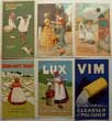
Lever Brothers, Ltd.
(6 Loose wash-day card adverts.)
Sunlight Soap, Lux Shampoo, Vim.
Date. [c.1900.]
England, Port Sunlight. Image sizes [4 x 7ins.] 6 Loose printed colour, (Chromolithographic), card adverts, very good condition.
William Hesketh Lever (later the first Lord Leverhulme) began manufacturing soap in England in 1884. His model plant and community near Liverpool was called Port Sunlight. In 1888, Lever began selling separately wrapped soap "tablets" as Sunlight Soap. £40.00
|
Click on picture above to view more images
How to order
|
|
(Code No. 5135)
Cheesbrough, J & Nicholson, Samuel, 1787-1878. artist.
(2 Antique Wirral Prints.)
Hooton Hall in Cheshire & Hooton Hall taken down 1778.
Dates. 1821 & 1816.
London. Lackington & Co. Page size 12 x 9 1/2ins. image size 7 x 9ins. Copper engraved print, foxing & lithographic print of Hooton Hall, some slight marginal marks not affecting image. £55.00
Hooton Hall was easily one of the finest houses in the north west, perhaps even in the country. Despite it's comparatively small size, the quality of the house, with it's distinctive columns, vast orangery, and extensive park meant that this was an estate that which should've survived. Yet, industrialisation and World War I meant that the hall became another of the lost houses.
|
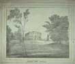
Click on picture above to view more images
How to order
|
|
(Code No. 5127)Ensign SMITH of the 60th C.R.V. (Cheshire Rifle Volunteers) his affair at CHESTER with the Fenians. An Historical Romance of the Nineteenth Century.Date. ca1850.Chester ? 4to, ( 12 x 9 ins.) Engraved title page + 15 Lithographic full-page plates with descriptive text below each plate, some foxing. Original pictorial wrappers, marked and chipping to edges. Possibly published in Chester, a satire on the exploits and the expense to the citizens of Chester regarding the "Cheshire Rifle Volunteers".
|
SOLD.
|
|
(Code No. 5074)
CARY, John.
(Large Antique Map.)
A NEW MAP OF CHESHIRE, divided into Hundreds exhibiting its Roads, Rivers, Parks, &c.
Date. 1801
Original hand-coloured copper engraved map, very good. A beautiful engraved map coloured in hundreds, similar to Smith's map of Jan, 1801....£80.00
|
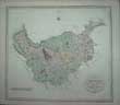
Click on picture above to view more images
How to order
|
|
(Code No. 5068)Nicholson. Francis.( 1753 – 1844). (Artist.)Chester Castle. (UK).Date. 1822.Chester, Printed by C. Hullmandle. Page size, [15 x 10ins.] Original lithographic print by Francis Nicholson, very good. Francis Nicholson ( 1753 – 1844) was a British artist. He worked in watercolour and oil, and is mainly known as a landscape artist.
|
SOLD.
|
|
(Code No. 5067)Nicholson. Francis.( 1753 – 1844). (Artist.)Beeston Castle, Cheshire.Date. 1822.Chester, Printed by C. Hullmandle. Page size, [15 x 10ins.] Original lithographic print by Francis Nicholson, slight foxing. Francis Nicholson ( 1753 – 1844) was a British artist. He worked in watercolour and oil, and is mainly known as a landscape artist.
|
SOLD.
|
|
(Code No. 5058)Stewart-Brown, R.Birkenhead Priory and the Mersey Ferry.Date. 1925.Liverpool, The State Assurance Company. 8vo, [6 x 9ins.] Pp xiv, 197. Illustrated throughout, some folding. Original cloth gilt, very good. No Dust jacket. Birkenhead Priory is in Priory Street, Birkenhead, Merseyside, England. It is the oldest standing building on Merseyside. The remains of the priory are a Grade I listed building and a Scheduled Ancient Monument. It was founded about 1150 by Hamon de Masci, 3rd Baron of Dunham Massey for the Benedictine Order.
|
SOLD.
|
|
(Code No. 5016)Pickering. G.( Antique Print of Chester).Northgate Street, Chester. (UK.)Date. [c.1830.]Chester, John Seacome. Page size 11 x 8 1/2ins. Image size 7 x 9 3/4ins. Original lithographic engraved print by W. Day & Haghe, very good.
|
SOLD.
|
|
(Code No. 5015)
PROUT, JOHN SKINNER (1805-1876), artist.
Bridge Street, Chester.(UK).
Date. [c.1839].
London: Ackermann & Co. Chester: Boult & Catherall, Page size [14 1/2 x 10 3/4ins.] Original lithographic print, slight foxing. £30.00
Prout acquired some knowledge of lithography and was largely self-trained as an artist. He spent much time in the west of England making topographical views of ancient monuments and in 1838 his "The Castles and Abbeys of Monmouthshire" was published in London. He visited the Wye valley and also sketched views of Chester.
|
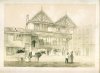
Click on picture above to view more images
How to order
|
|
(Code No. 5010)Nicholson. Francis.( 1753 – 1844).(Antique print.)Bridge Street, Chester. (UK.)Date. 1821. Chester, Printed by C. Hullmandle. Page size, [14 x 10ins.] Original lithographic print by Francis Nicholson, very good condition.Francis Nicholson ( 1753 – 1844) was a British artist. He worked in watercolour and oil, and is mainly known as a landscape artist.
|
SOLD.
|
|
(Code No. 4970)
William R. A. Daniell, [1769-1837]:
The Lighthouse on Point of Air, Flintshire.
Date. 1816.
London. Longman & Co. Image size 9 1/2 x 6 3/4. Page size 15 x 11ins. Original aquatint, drawn and engraved by William Daniell. Taken from "A Voyage round Great Britain" No 35, Volume 2. £55.00
View shows the Lighthouse with Lake District and the top end of the Wirral in the far distance. William Daniell commenced a tour in a rowboat around Great Britain in the summers of the years 1813-16 starting and ending at Lands'-End in Cornwall. As he went he drew a series of 308 hand coloured sketches illustrating the character and prominent features of the coast. During the winter times he returned home to produce watercoloures and aquatints. A magnificent series of plates, almost all of equal quality. Valuable as a record and exquisite in its presentation. It is the most important plate book on British Topography.
|
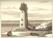
Click on picture above to view more images
How to order
|
|
(Code No. 4956)
(Sale Catalogue)
Particulars of Sale of a Freehold Estate at Guilden Sutton & Christleton near Chester. (UK).
Date. 2nd September, 1852.
Chester, Thomas. 4to, [8 1/4 x 13ins.] Title + [1], pp. 3 + Large folding estate map, size [ 23 1/2 x 20ins.] of Guilden Sutton & Christleton, small hole to fold, to be sold in 7 separate farm lots. Total 558 acres. Listing named farmers + farm & out buildings + fields names with their sizes + tithe rent charges. £45.00
|
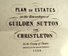
Click on picture above to view more images
How to order
|
|
(Code No. 4922)Twycross Edward.(Antique Print.)Ashfield Hall. ( Neston, Cheshire), The Seat of John Winder Lyon Winder, ESQ.Date. 1850.London, C. Graft. Page size, [14 x 10 1/2ins.] Original lithographic print by W.Gauci. Ashfield Hall is an Italianate structure with Ionic portice built of Ashlar stone. Only the ground floor storey with some fine carved door surrounds survive. Architect: Joseph Hayes Lyon Esq for John Winder Lyon Winder Esq of Vaynor Park Montgomeryshire.
|
SOLD.
|
|
(Code No. 4913)Nicholson. Francis. ( 1753 – 1844). (Artist.)Lamb Row, Chester. (UK).Date. 1821. Chester, Printed by Rowney & Forester, Rathbone Place. Page size, [14 x 10ins.]Original lithographic print by Francis Nicholson, very good condition. In 1821, Lamb Row, Bridge Street collapsed into the road, but nobody was injured. It had been built as the home of Randle Holme, Mayor of Chester, [ca.1650], but then became a tavern under "the Sign of the Lamb".Francis Nicholson ( 1753 – 1844) was a British artist. He worked in watercolour and oil, and is mainly known as a landscape artist.
|
SOLD.
|
|
(Code No.4867)
PROUT, JOHN SKINNER (1805-1876), artist.
Pemberton's Parlour on the Walls Chester. (UK.)
Date. [1839].
London: Ackermann & Co. Chester: Boult & Catherall, Page size [14 1/2 x 10 3/4ins.] Original lithographic print, spotting to outer margins not affecting image. £30.00
Prout acquired some knowledge of lithography and was largely self-trained as an artist. He spent much time in the west of England making topographical views of ancient monuments and in 1838 his "The Castles and Abbeys of Monmouthshire" was published in London. He visited the Wye valley and sketched the antiquities of Chester.The site of a medieval watch tower when it was known as Dille's Tower and, subsequently, the Goblin Tower. It was reconstructed in the 18th century as part of improvements to the Walls. Its current name is thought to originate from its use by John Pemberton. He had a rope works below and used the tower to keep an eye on his workmen.
|
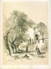
Click on picture above to view more images
How to order
|
|
(Code No. 4843)Moule, Thomas.CHESHIRE.(Antique Map, Guaranteed over 140 yrs old ).Date, [1836 -52.]London. Virtue. Page size 10 3/4 x 8 1/2ins. Original steel engraved hand-coloured county map of CHESHIRE, strengthened fold on back of map. Decorated with vignettes, view of Eaton Hall and Chester Cathedral. Ornamental border with symbolic figures woven into the design, heraldic coat of arms. Moule's county maps are the last series of decorative maps to be published.
|
SOLD.
|
|
(Code No. 4839)YOUNG, Harold Edgar.A Perambulation of the Hundred of Wirral in the County of Chester.Date. 1909.Liverpool, Henry Young & Sons. 8vo, [6 x 9ins.] Pp. xix, 220. Illustrated throughout + folding Map, very good. Top edge gilt, Edges untrimmed. Original cloth gilt.
|
SOLD.
|
|
(Code No. 4838)Andrews, William.Bygone Cheshire.Date. 1895.Chester, Phillipson & Golder. 8vo, [6 x 9ins.] Pp [4] 253, [8] Publisher's adverts. Illustrated throughout. Original cloth gilt, slight marks. The author compiles incidents and details of Cheshire life by various authors, e.g. Linnaeus Banks, W. Harrison, (architect), Thomas Frost and others.
|
SOLD.
|
|
(Code No. 4837)Kaighin. J. R.Bygone Birkenhead. Sketches round and about the Sixties.Date. 1925. Birkenhead. Willmer Bros & Co. 8vo, [ 6 x 9 ins.] Pp 373, (2) index. Original cloth, slight marks & faded spine. The author reproduces incidents and details, insignificant in themselves, but to a person interested in Birkenhead life in the 1860s this book is essential reading.
|
SOLD.
|
|
(Code No. 4836)Stewart-Brown, R.Birkenhead Priory and the Mersey Ferry.Date. 1925.Liverpool, The State Assurance Company. 8vo, [6 x 9ins.] Pp xiv, 197. Illustrated throughout, some folding. Edges untrimmed. Original cloth gilt, very good. .Birkenhead Priory is in Priory Street, Birkenhead, Merseyside, England. It is the oldest standing building on Merseyside. The remains of the priory are a Grade I listed building and a Scheduled Ancient Monument. It was founded about 1150 by Hamon de Masci, 3rd Baron of Dunham Massey for the Benedictine Order.
|
SOLD.
|
|
(Code No. 4835)Beazley F.C.Notes on the Parish of Burton in Wirral. Date. 1908. Limited edition of 200. copies. Liverpool, Henry Young & Sons. 8vo, [ 6 x 9ins.] Pp 107. Illustrated throughout, all with tissue guards. Original cloth gilt. Very good copy. The picturesque village of Burton was first documented in the Domesday Book and historically was on the route, which travellers would take from London to Birkenhead.
|
SOLD.
|
|
(Code No. 4518)
Pennant, Thomas, 1726-1798.
Journey from Chester to London.
Date. 1811.
London. Wilkie and Robinson... 4to, 6 1/4 x 9 3/4ins. Pp viii, 622 + 6 copper engraved plates, slight foxing. Original full morocco gilt. Raised spine bands gilt with gilt-tooled decorated panels, slight rubbing. All edges gilt. All edges gilt. £110.00
Thomas Pennant's son David edited this work. Thomas Pennant was a prolific writer specialising in travel and natural history, one of his most popular works on travel was his tour to Scotland in 1769. The correspondence he received from Gilbert White was the basis for White's book "The Natural History and Antiquities of Selborne". Unfortunately Pennant's letters to White have been lost.
|
Click on picture above to view more images
How to order
|
|
(Code No. 4834)Beazley .F.C.Notes on Shotwick in the County of Chester.Date. 1915.Liverpool. Edward Howell. 8vo, [6 x 9ins.] Pp xii, 176. Illustrated throughout. All with tissue guards. Original cloth gilt, spine faded.Shotwick is a village and civil parish on the Wirral Peninsula in the unitary authority of Cheshire West and Chester and the ceremonial county of Cheshire, England. The village is situated close to the border with Wales. Shotwick Castle built about 1093. The design encompassed an earthen motte with an outer bailey above the River Dee. Its main purpose was to defend a tidal ford across the river between England and Wales.
|
SOLD.
|
|
(Code No. 4833)
Gamlin, Hilda.
Memories or The Chronicles of Birkenhead. The Scenes and People of its Early Days.
Date. 1892.
Liverpool. Edward Howell. 8vo, [5 x 7 1/2ins.] Pp. viii, 106, [ 33 pages of Birkenhead trade adverts} + 8 illustrations. Original cloth gilt, slight rubbing & marks. £40.00
|
Click on picture above to view more images
How to order
|
|
(Code No. 4790)Gresty. John.(Antique Print of Chester .)Eastgate Street.Date. [c.1870].Chester. (UK.) Chester. John Gresty. Page size, [14 x 10 1/2ins.] Image size [11 x 8 1/2ins.] [14 x 10 3/4 ins.]. Original coloured lithographic print. taken from Gresty's Illustrated Chester, Consisting of Eight Large Lithographic Views of Chester. John Gresty had a shop at 29 Eastgate Street and a printing works for letterpress and lithography at 43 Watergate Row. He was in business in 1865 as "Evans & Gresty", publisher. Ref :- History of Printing in Chester.
|
SOLD.
|
|
(Code No. 4761)Leycester. PeterHistorical Antiquities in two Books; the first treating ... of Great-Brettain and Ireland; the second containing particular remarks concerning Cheshire. ... Wherunto is annexed a transcript of Doomsday-Book, so far as it concerneth Cheshire, taken out of the original Record.Date. 1673 1st edn.London. Robert Clavell. Folio [8.5 x 13.5ins]. Frontis map of Cheshire by John Speede, slight split at fold + Title page in red and black + Dedication + To the Reader pp. (6) + Text pp. 7-437 + Preface pp. (1) + Lists of Cheshire families with their coats of arms. Original full calf gilt, raised spine bands gilt, rubbed with some wear. Hinges split, holding firm. Map title: - "The Countye Palatine of Chester with the most Ancient Citie Described" Sold by Roger Rea, (plain back), Map size 18 x 20.5ins. Scale of miles,10 [ = 3 3/8 ins.]. Seven coats of arms of nobility. Plan of Chester copied from the Braun & Hogenberg's Civitates Orbis Terrarum plus galleons, sea monsters, cherubs and coats of arms.The Cheshire map that accompanies this work is either by John Speede or the Anonymous Mapmaker, (William Smith). Leycester's Historical Antiquities with the appropriate map is extremely rare.
|
SOLD
|
|
(Code No. 4744)
Perrot. A.M. & G.B. Deeping.
(Antique Print.)
Eaton Hall on the river Dee near the City of Chester in Cheshire.
Paris. Page size 7 x 6 1/2ins. [c.1823.] Original copper engraved print of Eaton Hall by G.B. Deeping. Modern colouring. £35.00
|
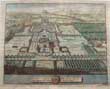
Click on picture above to view more images
How to order
|
|
(Code No. 4703)ASPINALL, Henry Kelsall.Birkenhead and its Surroundings. Topographical, Biographical, Autobiographical, Anecdotal and Whimsical .Date. 1903.Liverpool: The Liverpool Booksellers’ Company. 8vo. Pp. xxiii, 373 + Illustrated throughout. Original cloth gilt. Fine copy. The author's personal reminiscences of his native town and its surroundings also his thoughts on the many leading Wirral characters of the day.
|
SOLD.
|
|
(Code No. 4696)Plan of the Liverpool and Birkenhead Docks, 1863. Scale of feet [about 800 to an inch].(Antique Map of Liverpool.)Date, 1863.Liverpool and Manchester, Page size 45 x 25ins, folding to 7 1/4 x 8 1/4ins. Dissected linen backed map. Large map of the Dock areas of Liverpool and Birkenhead Docks, slight marks. Original full morocco decorated gilt covers, rubbed with split to hinges..
|
SOLD.
|
|
(Code No. 4630)
Senex, John.
(Antique strip road map)
The Road from Towcester, Daventry, Coventry
and
Great Haywood, Stableford, Stone, Nantwich,Tarporley, Chester and Hawarden. (printed back to back on a single sheet, Nos. 22 & 23?). Actually Surveyed by a Wheel ...
London. John Bowles and Son, The Black Horse, Cornhill, London, Page size 9 x 7 1/4ins. 1757. Original copper engraved strip maps, road maps, hand coloured engraving, scale about 2-2.5 miles to 1in by J. Senex. First perform'd and publish'd by John Ogilby, Esqr; And now improved, very much corrected, and made portable by John Senex. £35.00
Senex's two volume road atlas was much smaller than Ogilby's "Britannia" and would fit into a traveller's pocket.
|

Click on picture above to view more images
How to order
|
|
(Code No. 4616)Trevor, John.Panorama of the City of Chester; containing its Curiosities, Antiquities and Ancient and Present State;with a Visit to Eaton Hall; intended as a Pocket Directory.Date. 1843, 2nd edn.Chester. Edward Parry.. 12mo, 4 x 6ins. Pp [9] 172, slight foxing + Map of Chester + 21 Engraved prints of Chester, (as called for). Print 4, (Northgate) substituted, now Handbridge Gate moved to page 40, (binding error). Original cloth gilt, slight fading.
|
SOLD.
|
|
(Code No. 4594)
Meisner, Daniel.
Chester, (UK).
(Antique Chester Town Plan).
Date. [c.1630.]
Frankfurt. Image size 150 x 95mm. Original copper engraved view of Chester with German verse below. Bird's-eye view with foreground figure, foxing spots. Published in Daniel Meisner's 'Thesaurus Philo-Politicus, 1624-30. (Guaranteed to be over 350 years old.) £130.00.
|
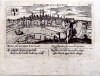
Click on picture above to view more images
How to order
|
|
(Code No. 4591)Allom.T and others.CHESTER & EATON HALL.(8 ANTIQUE PRINTS of CHESTER.)Date. 1830-60.London. Approx, images size 6 X 4 ins & images size 7 x 5ins. 8 Original steel and lithograph engraved prints of Chester & Eaton Hall some marginal foxing.
|
SOLD.
|
|
(Code No. 4590)
Grose. Francis,
(6 ANTIQUE PRINTS of CHESTER.)
CHESTER.
Date. [c.1784.]
London. S. Hooper. Approx, 4 images, size 6 X 4 1/2 ins & 2 images, size 4 x 4ins. 4 Original copper engraved prints of Chester Bridge, Chester Castle, Plate 1, and Chester Castle, plate 2, some marginal foxing + 2 Smaller copper engraved of the Water Tower and Chester Castle. The prints are guaranteed to be over 150 years old. £45.00
|
Click on picture above to view more images
How to order
|
|
(Code No. 4564)
Groom, Robert.
(Antique Lithographic Print.)
Principal Enterance to Birkenhead Park.
Date. [c.1850.]
Birkenhead. James Cross, Stationer, etc. Page size 17 x 11 1/2ins. Image size 11 x 7ins. Original lithographic print by Robert Groom, printed by McLean & Co, London. £60.00
Birkenhead Park, designed by the Landscape Gardener Joseph Paxton (later Sir Joseph Paxton) in 1843 and officially opened in 1847, is acknowledged to be the first publicly funded park in Britain. It was the forerunner of the Park's Movement and its influence was far reaching both in this country and abroad - most notably on Olmstead's design for Central Park, New York.
|
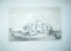
Click on picture above to view more images
How to order
|
|
(Code No. 4389)
SCOTT,COOPER, S. Rev.
Lectures on the History of St. John Baptist Church and Parish in the City of Chester.
Date. 1892.
Chester. Phillipson & Golder. 8vo. Pp xii 304. Illustrated throughout. Original cloth, slight marks and darkened spine. £22.00
|
Click on picture above to view more images
How to order
|
|
(Code No. 4359)Boyd, A. W.A Country Parish. Great Budworth in the County of Chester.New Naturalist.Collins, London, 1951. 8vo, [6 1/4 x 9ins.] Pp xvi, 278 , [2] + Illustrations throughout. Original cloth, gilt, very good condition. No dust jacket.
|
SOLD
|
|
(Code No. 4316)WOODS, E. Cuthbert and BROWN, P. Culverwell.HE RISE AND PROGRESS OF WALLASEY. A History Of The Borough.Birkenhead. Willmer Brothers & Wallasey Corporation. 8vo, [ 6 x 9 ins.] 1960, revised. Pp (10), 412 + Folding Map + Illustrations throughout. Original cloth gilt, marked and faded spine. (no dustjacket).
|
SOLD
|
|
(Code No. 4270)Moule, Thomas.CHESHIRE.(Antique Map, Guaranteed over 140 yrs old ).London. Virtue. Date 1836-52. Approx size, [11 8 1/2 ins.] Steel engraved county map of CHESHIRE. decorated with two vignettes, Eaton Hall and Chester Cathedral. Ornamental border with heraldic coat of arms. Moule's county maps are the last series of decorative maps to be published.
|
SOLD.
|
|
(Code No. 4250)Tobin. Isabel, Miss.The Parish of Eastham.Liverpool. Daily Post. 1920. 8vo, [6 x 9 ins.] Pp 62, (12). Illustrations throughout, very good condition. Original boards, marked.
|
SOLD.
|
|
(Code No. 4222)
Pickering, G.
(Antique Print.)
Water Tower, Chester, The Museum of the Mechanics Institution. (Cheshire).
No Date, ca1850. (Reprint of the 1830 edition.)
Chester. Size 11 x 9 ins. Original lithographic print taken from a drawing by G, Pickering, nicks and marks to outer edges, not affecting the image. 3 other copies available. £18.00
|
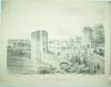
Click on picture above to view more images
How to order |
|
(Code No. 4163)Buck, Samuel and Nathaniel.(3 Aniique Prints of Cheshire.)The South View of a Religious Ruin, Near Chester, (Stanlaw),The South West View of Birkenhead Priory...,The South View of Halton Castle....1st Edn.Date 1727or later edition. Print sizes 171/2 x 10 1/2 ins to 16 1/2 x 9 1/2 ins. Image sizes 14 x 7 1/2 ins, (approx). 3 Original copper engraved prints.The brothers, Samuel and Nathaniel Buck drew and engraved a series of etched panoramas of British towns, castles and abbeys etc. The engraving describes below the image, the history of the castle, from Norman times to the early 18th century, including the numerous changes of ownership. The View of Halton Castle print numbered 16 in the left hand blank margin, signifying that it is the 1st edition, not the later 18 Century reprints.
|
SOLD
|
|
(Code No. 4128)Richards, Raymond.Old Cheshire Churches, a survey of their History, Fabric and Furniture with records of the older Monuments.With a supplementary survey relating to the Lesser Old Chapels of Cheshire.Didsbury: E J Morten. 1973, revised and enlarged edition. 4to, [9 1/2 x 11 1/2ins]. Pp xxvii, 905, very good. Illustrated throughout, folding map, plans, etc. Original cloth gilt, very good. Dust jacket, slight spotting..
|
SOLD.
|
|
(Code No. 4127)
Buck. Samuel and Nathaniel.
(Guaranteed Antique Prints.)
North West View of CHESTER CASTLE.
Date 1727or later edition. Print size 171/2 x 11 ins. Image size 14 x 7 1/2 ins. Copper engraved coloured print (modern colouring).£45.00
The brothers, Samuel and Nathaniel Buck made a series of etched panoramas and views of British towns, castles and abbeys in the early 18th century.
Most of the old Chester Castle was demolished in about 1807; it is now been used for holding of Assizes and County Sessions.
|
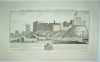
Click on picture above to view more images
How to order |
|
(Code No. 4113)Sulley. Philip.The Hundred of Wirral.Birkenhead. B. Haram & Co. 1889. 8vo. Pp xi, 400, xxxii. Text illustrations throughout. Lacking Map & frontis. Cloth gilt, worn. Holding firm........
|
SOLD.
|
|
(Code No. 4097)
Swertner. J.
(Antique print)
View of Hyde Hall. Cheshire.
Date,1795. London. j. Stockdale. Page size (approx), 11 1/2 x 9 ins. Original copper engraving by Sparrow, (Modern Colouring), very good condition.
Print is guaranteed to be over 200 years old. £30.00
|

Click on picture above to view more images
How to order |
|
(Code No. 4095)Hogg. A. & Francis Grose.(4 Antique Prints.)BEESTON CASTLE.London. S. Hooper & Hogg. A. 1784. Approx size 11 X 7 ins to 8 1/2 x 7 ins. 4 Original copper engraved prints of Beeston Castle, Cheshire, some marginal foxing.Prints are guaranteed to be over 150 years old.
|
SOLD
|
|
(Code No. 4094Grose. Francis.(3 ANTIQUE PRINTS).CHESTER.London. S. Hooper. 1784. Approx size 11 X 7 ins. 3 Original copper engraved prints of Chester Bridge, Chester Castle, Plate 1, and Chester Castle, plate 2, some marginal foxing.Prints are guaranteed to be over 150 years old.
|
SOLD
|
|
(Code No. 4093)Nicholson Francis, (1753-1844).(Antique Chester Print.)At Flookersbrook near Chester.1821. Printed by Rowney & Foster. Page size 11 x 15 3/4 ins. Original lithographic print with hand colouring, (modern colouring), of Flookersbrook near Chester.Nicholson was born in Yorkshire in 1753. He worked in watercolour and oil and is mainly known as a landscape artist. He became one of the founders of the Society of Painters in Watercolours.Print is guaranteed to be over 150 years old.
|
SOLD.
|
|
(Code No. 3941)Didsbury. E.Morten. 1979 3rd imp. ( Reprint of the 1847edn). pp xvii 440+36, vg. Illustrated throughout. Folding map, vg. Original cloth gilt, vg. D/j , nicks to edges.
|
SOLD
|
|
(Code No. 3935)Armstrong, John.A History of Freemasonry in Cheshire, being a Record of all Extinct and existing Lodges, Craft and Mark, and Royal Arch Chapters, provincial Grand Lodges, Craft and Mark, and provincial Grand Chapter.London. George Kenning. 1901,1st edn. 8vo. No. 232 of 500 copies. Signed by the Author. Pp.xxii, 540. Illustrated throughout. Original cloth gilt, slight marks and faded spine.
|
SOLD
|
|
(Code No. 3810).
Anon:
History of Disley
and Handbook of Sale of Work 1903. Written in aid of the proposed Disley Institute.
Manchester. James Collins. 1903. 8vo. Pp [1] 92, [1]. Illustrated throughout. Showing people places and history + trade directories and adverts etc. Original cloth, poor with slight loss. £40.00
|
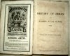
Click on picture above to view more images
How to order
|
|
(Code No. 3733).Birkenhead. Willmer Bros & Co. 1925. 8vo, [ 6 x 9 ins.] Pp 373, (2) index. Original cloth, poor. The author reproduces incidents and details, insignificant in themselves, but to a person interested in Birkenhead life in the 1860s this book is essential reading.
|
SOLD
|
|
(Code No. 3714.)Chester. Courant Office. 1857. 8vo, [ 8 x 9 ins.] Portrait frontis photograph + Title page (as above) + Patrons + pp. v-iv Rules + pp. vii-xi Members + pp. xii-xiv List of plates + pp. xv-xvi Preface + pp. Text 1-478, [12] Index. + 120 Lithographic, woodcut and steel engraved plates, some folding, slight foxing. Lists genealogy and family history, local history, architecture and topography of mainly the Chester area. Original half calf gilt, damaged.
|
SOLD
|
|
(Code No. 3713).
HISTORIC SOCIETY OF LANCASHIRE AND CHESHIRE. PROCEEDINGS AND PAPERS; SESSION IV. 1851-52.
Liverpool. Direction of the Council. 1852. 8vo [ 8 x 9 ins.] Title page (as above) + Advertisement + Direction to the binder + Plate notes + pp. iv-v Contents + pp. vi-xv List of members + pp. 1-220 Text + Session V + pp. vii-xviii + pp 1-236 Text + 48 Lithographic, woodcut and steel engraved plates, some folding, slight foxing and split to folds. Lists genealogy and family history, local history, architecture and topography of mainly the Wirral and Liverpool. Original half calf gilt, damaged. £90.00
|
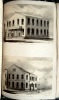
Click on picture above to view more images
How to order
|
|
(Code No. 3705).
Fenwick, George Lee.
A History of the Ancient City of Chester from the Earliest Times.
Chester: Phillipson & Golder, 1896. 4to, Pp viii, 578 + 18 b/w plates, Original red cloth gilt, rubbed & faded spine. £70.00
|
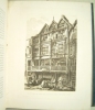
Click on picture above to view more images
How to order
|
|
(Code No. 3677).Howson, J S. & Rimmer, Alfred:Chester as it was.London. Longmans, Green and Co. 1872. 4to, [ 10 x 12 ins ]. Pp 39 + 10 Photo-lithographed plates, (as listed). Original brown cloth gilt, slight rubbing.
|
SOLD.
|
|
(3631)London. William Mackenzie. ca1867. 4to, 10 x 12ins. 2 Volumes in 4. Pp. 720, 464, cclx + 25 Steel engraved plates, vg. Original gilt decorated cloth, Spines faded and slight split to hinges. Still firm. Ex library,"Scarborough Philosophical and Archaeological Society" no stamps to text or plates. All edges gilt. Weight of Books, 10.5 Kg (approx).
|
SOLD
|
|
(Code No.3584).Folio [15 1/2 x 11ins]. Ca1900. 150 Photographs of Shropshire & Cheshire pasted into an album. [ sizes approx 11 x 9 ins to 5 1/2 x 3 1/2 ins]. 80 Post card size. Approx areas shown :- Northwich, Whitchurch, Shrewsbury, Church Stretton, Much Wenlock, Bridgenorth, Ludlow, Great Budworth, Clun, Arley and Tenbury, etc. Original full morocco gilt, split to front hinge. Holding firm.
|
SOLD
|
|
(Code No. 3402)Chester. J,Romney, Oulton Place. 4to, [8 1/2 x 10 1/2 ins.] 1853. Frontis + Engraved title page (v. blank) + Preface (v. blank) + pp.ii list of subscribers + 32 Engraved plates with a separate description accompanying each plate, slight foxing. Original cloth gilt, faded and split to front hinge. Morocco title label on front cover.
|
SOLD
|
|
(Code No. 3406)Gresty. John:"Gresty's Illustrated Chester, Consisting of Eight Large Lithographic Views"Chester. John Gresty. Oblong 4to, [14 x 10 3/4 ins.]. ca1870. Folding coloured panorama of Chester + Engraved title, some foxing + Coloured Chester town plan + 7 Coloured lithographs with a separate description accompanying each plate mostly listing the businesses and named traders + pp. [19] Directory and Chester trade adverts. Original cloth gilt, faded and chipped.
|
SOLD.
|
|
(Code No.3152)Mason. W.I and A. W. Hunt:The History and Antiquities of Birkenhead Priory.London. Liverpool. Parker. Pearce & Brewer. 1854. Folio. [380 x 275mm]. Pp 16, slight foxing. 15 Lithographs plates of Wallasey and Bidston villages etc, also including 4 plans, and elevations, slight foxing. Modern half morocco gilt, retaining the original gilt title label on front cover.
|
SOLD.
|
|
(Code No. 2827)Palin. John, (Surveyor)7 TURNPIKE ROAD MAPS. " Plans and Sections of the CHESTER, FARNDON, and WORTHENBURY Turnpike Road"Chester. Barker and Hignett, (Solicitors). 1853. Elephant folio. (20 x 29 ins) 7 Lithographic maps of plans and sections with original outline hand colour by "Evans, Gresty and Dunhill, Lithographers, Chester", some marginal nicks. Original linen covers with linen title label to upper cover. Fine calligraphic titles, Compass indicator, "Notes" and 2 Scale Lines, (Chains and Miles, 5 miles to the inch). Road starts at the stone step of the Jolly Gardener Pub, Boughton and ending at Worthenbury, passing through the parishes of Huntington, Aldford, Buerton, Churton, Caldecott. RARE COPY.
|
SOLD.
|
|
(Code No. 3520)Mortimer, William Williams:The History of the Hundred of WIRRAL, with a sketch of the City and County of Chester, Compiled from the Earliest Authentic Records.London & Birkenhead. Whittaker and Co. 4to, [9 x 12 ins]. 1847. Pp xvii (4) 440, 36 + Folding map, creased + Folding table + 11 Engraved plates, very good. Original trade boards, rubbed and slight split to hinges, still firm. An elaborate bookplate by V. Thorne on front past down.
|
SOLD.
|
|
(Code No. 3514)
Ogilby. J, 1600 -76. (Antique Road Map).
"The Road from CHESTER to CARDIFF"
London. Page size 19 1/2 x 15 1/2 ins. 1675. Original copper engraved coloured strip-map, (Modern Colouring), very good. John Ogilby, bookseller, translator, printer, dancing master, theatre owner, master of the King's Revels and finally a geographer. He published his "Britannia" 1675 in a very practical, arrangement of the roads on continuous strips, six or seven to a plate. He was the first to adopt the statute mile of 1,760 yards. The map, Chester to Cardiff is in two parts, this being the first part, Chester to New Town, Montgomery. £170.00
|

Click on picture above to view more images
How to order
|
|
(Code No. 3509)
Burlington. Charles
"South Prospect of the City of CHESTER"
London. Page size 14 1/4 x 8 3/4 ins. 1779. Original copper engraved print, very good condition. Guaranteed to be over 200 years old. £35.00.
|

Click on picture above to view more images
How to order
|
|
(Code No. 3508)
WALPOOLE. George. Augustus
"Prospective View of CHESTER, in the County of Cheshire".
London, Alex, Hogg. 1784 1st edn. Folio. Page size, [ 14 1/2 x 9 ins ]. Original copper engraved print, very good condition. Guaranteed to be over 200 years old. £35.00.
|

Click on picture above to view more images
How to order
|
|
(Code No.3495)
Mercator, G., & Hondius, J.
( Antique Map of North West of Britain)
"Von Engelandt" "Lancastria, Cestria, Caernarvan, Denbigh, Flint, Merionidh, Montgomery, Salopia, Cardigan, Radnor, Wigornia, et Ins Anglesey"
Amsterdam. J, Jansson. Oblong 4to [8 x 5 1/2 ins]. 1651, 8th edn. Hand coloured copper engraved map, very good. German text. Guaranteed to be over 320 years old. £110.00
|
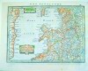
Click on picture above to view more images
How to order
|
|
(Code No.3494)
Mercator, G., & Hondius, J. ( Antique Map of North West of Britain)
"Angliae 111 Tabvla" " Westmorlandia, Lancastria, Cestria, Caernarvan, Denbigh, Flnt, Merionidh, Montgomery,Sa: Lopia Cum insuls Mania et Anglesey"
Arnheim. Gerardi Mercator. Oblong 4to [10 x 7 1/2 ins]. 1610 4th edn. Original hand coloured copper engraved map, wormhole in border. On the back is page 76 of the Latin text. Guaranteed to be over 350yrs old. £130.00
|
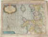
Click on picture above to view more images
How to order
|
|
(Code No.3496)Bowen. Emanuel, (Antique Map of Cheshire):Cheshire Divided into its Hundreds.... etc.London. W. Owen, Temple Bar. 8vo [7 x 5 3/7 ins]. 1761. Original copper engraved map, very good, water stain to outer edge of blank margin. From the General Magazine of Arts & Sciences first published in 1759. Guaranteed to be over 220yrs old.
|
SOLD.
|
|
(Code No.3497)
Conder, T. (Antique Map.)
Cheshire, "A New & Correct Map of Cheshire Drawn from the Best Authorities".
London. Alex Hogg. 1784. Map image size 7 1/2 x 6 ins. Hand coloured copper engraved map. Title on a mural design with cheeses, a churn and cow. Chester coat of arms. "Remarks" and circular compass indicator. Separate scale line. Floral decorated borders, a contemporary base border added. From -"Walpoole's Traveller" £55.00
|
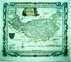
Click on picture above to view more images
How to order
|
|
(Code No. 3485)Chester. Printed by J. Fletcher. 8vo. 1831. Pp iv, 431. 444, (4) index + 28 view plates and maps, two of the maps are in facsimile + 109 Additional portraits and views of Chester taken from various sources and county histories by Pennant, Allom, Grose, Cuitt, Batenham etc. Modern half calf gilt,
|
SOLD
|
|
(Code No. 3474)
(Antique Print).
"The Cathedral Church of Chester"
Nd, ca1720. Page size 23 1/2 x 13 3/4 ins. Image size 22 1/2 x 11 3/4 ins. Original copper engraved plate by Bickham, creasing to edges of plate. The animated figures in the foreground add a social dimension to a fine and rare early 18th century architectural view of Chester Cathedral before the Victorian "Improvements". £150.00
|
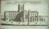
Click on picture above to view more images
How to order
|
|
(Code No. 3473)CAMPBELL, Colin. (Antique Print of Cholmondeley Castle/House)."The Geometrical Plan of the House, Gardens and adjacent Parts of Cholmondley in Cheshire, the Seat of the Right Honourable the Earl of Cholmondley"Published by Colin Campbell, 1725. Image size. 13 1/2 x 19 1/4 inches. Page size approx 18 x 21 ins. Original copper engraved plate by H. Hulsbergh taken from a drawing by Colin Campbell. From Colin Campbell's book of British architectual plans "Vitruvius Britannicus".
|
SOLD.
|
|
(Code No. 3472)
M.A.C. (Mary Ann Congreve) ( Antique Print.)
"Bp Wilson's Birthplace Burton Cheshire"
Cheshire. Burton, Lithographed by Mr. Dean, Douglas for private use only. ca1850. Page size 17 1/2 x 11 1/4 ins. Original lithograph/soft ground etching? by Mary Ann Congrave of the home of Bishop Wilson of Sodor and Man 1698-1755, Slight marks and nicks to outer edge. The Chester artist William Tasker was employed to teach Mary drawing and painting. Ref. Burton in Wirral, A History, edited by P.H.W. Booth. Page 112. £60.00
|
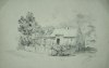
Click on picture above to view more images
How to order
|
|
London. 1783. Approx size 250mm x 170mm, Pp 27 to 39, vg + 6 Copper engraved views + Original hand coloured copper engraved map, with descriptive text below the map and continued at the back. Taken from the Cheshire section in Grose's Antiquities of England and Wales. The map is a reprint of a map first published in 1701 by John Seller for Camden's Britannia. Guaranteed to be over 200yrs old.
|
SOLD
|
|
(Code No. 3444)London. J. Boydell. 1749. Image size 17 x 11 ins. Page size 21 1/2 x 16 ins. Original copper engraved plate, drawn and engraved by J. Boydell, vg. Guaranteed to be over 250 years old.
|
SOLD
|
Code No. 3013. Evans & GrestySelect Views in the Ancient City of Chester and Its Vicinity.ca 1850.Size 250x140mm.
42 Beautiful steel engraved views on 5 pages + Town plan of Chester.Original decorated covers,foxing. |
SOLD |
|
(Code No. 2726)
Lysons. Daniel & Samuel:
Magna Britannia, of Great Britain. CHESHIRE.
Date. 1810.
London. Volume 2, Part 2. Folio, 12 x 15 ins. Pp 298 to 692, EACH TEXT PAGE INTERLEAVED with BLANK PAGES, sizes 10 x 14 1/2 ins, (watermarked 1818.) + 35 engraved plates (as listed) + 37 Extra-engraved plates, taken from Aikin's Manchester, Campbell's Vitruvius Britannicus, Walpoole's British Traveller etc, slight foxing. Modern Buckram. Lyson's Magna Britannia was published between 1806 -22, the intention was to research and publish the history of every county in England, unfortunately only about 10 counties were completed. . £350.00
|
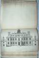
Click on picture above to view more images
How to order
|
|
(Code No: 2652)
Morden, R. (Antique Map.)
CHESHIRE. ("CHESHIRE by Robt Morden").
London. John, Nicholson. 1708. Map image size 215 x 165 mm. Copper engraved map. Oblong title panel. List of the Hundreds and separate scale line below. Graduated border. From the atlas -"Fifty Six New and Accurate Maps of Great Britain", Very Good Condition. £90.00
|

Click on picture above to view more images
How to order
|
|
(Code No: 2654)
Pigot & Son. (Antique Map.)
CHESHIRE.
London. Longman & Co. 1842. Map image size 165 x 103 mm. Hand coloured steel engraved map. Compass cross indicator. "Explanation" and top and bottom border scale and title lozenge + One printed page of "Distance Table" An attractive miniature map. From the atlas - "Pocket Topography and Gazetteer of England", Very Good Condition. £35.00
|

Click on picture above to view more images
How to order
|
|
(Code No: 2657)London. W, Coppett. 1832. Map image size 173 x 100 mm. Copper engraved map. A crude and very distorted outline map showing the towns. Compass cross indicator, and title in a lozenge-shaped frame. From the atlas - "Geographical Dictionary of England and Wales", Very Good Condition.
|
SOLD
|
|
(Code No: 2661)
Cary , J. (Antique Map.)
CHESHIRE.
London. J.Cary. 1st May, 1812. Map image size 90 x 130 mm. Copper engraved map with original outline hand colour. West at the top. Outside top borderline is the title panel. Resting on this panel, half of a star indicator of the points of the compass. "J. Cary" and "Engraver" to either side of title panel. Separate line scale. Panel with distances tables from London, on bottom border line. From the atlas - "Cary's Traveller's Companion". £35.00
|

Click on picture above to view more images
How to order
|
| (Code No.3156) London. John Stochdale. 28th March 1805. Pp 26, including full page plate, dust marks + Original hand coloured copper engraved folding map, page size 21 1/2 x 17 ins, image size 19 1/2 x 14 3/4 ins, engraved by John Cary taken from Camden's Britannia. Map showing town, village, hundreds (indicated by numbers), meres, turnpike and 3 canals (Chester, Walden ferry and Bridgewater). Elaborate star compass indicator. "Reference to the Hundreds" and scale and title. |
SOLD
|
|
(Code No. 3365)
Manchester. E, J, Morten. 8vo. 1970, reprint. Pp (6) 218 xviii, vg. Illustrated throughout. Dedication on front endpaper. Original cloth gilt. dust wrapper, slight chipping to top of spine, vg.
|
SOLD
|
|
(Code No. 3360)
Leicester, K, Alan.
A Nun's Grave. A Novel set in the Vale Royal of England.
Cheshire. Northwich. Leonie Press. 1999, reprint. 8vo. Pp vi 136. Decorated soft cover. £10.00
|
How to order |
|
(Code No. 3361)Dodgson. McN, J.Place-Names of CHESHIRE.Cambridge. University Press. 8vo. 1970. Pp.ix 329. The Place-Names of Bucklow Hundred and Northwich Hundred, Part 2. Original cloth gilt. D/w, poor.
|
SOLD
|
| (Code No.1053)Parks, Murray J. R N. (Marine Surveyor)A Chart of the Approaches to Liverpool from a Survey made by Direction of the Trustees of the Liverpool Docks. Liverpool.D, Mason. 1857. Linen backed hand coloured sea chart in 48 sections. Size 1245 x 1480 mm. Folding to size 255 x 165 mm. Showing the top of the Wirral including street plan of Birkenhead also Liverpool to Formby. Featuring profiles of prominent landmarks churches, tall buildings etc. Top and sides of chart show vignettes of pilot boats, the different light houses and buoys with explanation etc. Slight water staining to 2 sections.Vg. Original slipcase, gilt. Over flap missing, slight wear. |
SOLD.
|
|
Return to top
|
|