SITE CONTENT
Antique Maps & Prints
Britain
Antique Maps - World
Antique Books
Cartographers
Early Prints
Other Stock
|
| Maps, Books & Prints of Derbyshire |
Images |
|
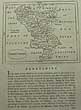
(Code No. 6624)
GROSE, Francis / Seller. J.
Map of Derbyshire.
(Antique Map).
Date. 1798.
London, Sold by H. H Symonds. Page size [7 x 10ins]. Original copper engraved map, The map is a reprint of John Seller's map Camden's Britannia abridged, J. Wild..
.Francis Grose had shown a keen interest in drawing, having attempted sketches of medieval buildings as far back as 1749, and having taken formal instruction at a drawing school 1750s. He was not a particularly gifted draughtsman but he mixed in the London artistic group and began to exhibit, first at the Society of Artists in 1767-8 and then at the Royal Academy. His interest was in the field of medieval remains...... £25.00
|
Click on picture above to view more images
How to order
|
|
(Code No. 6363)Rayner.Derbyshire Scenery.Date. [c.1830]. Published by J, Vallance, Centre Museum, Matlock Baths. 4to, [8 x 11ins]..14 Lithographic prints of Derbyshire scenery printed by G. Hullmamdel.. Views shown:- Matlock Bath. Matlock High Tor. Matlock Church. Dove Dale.Haddon Hall. Ilam Hall. Willersley Castle. Dove Dale North. 6 of Chatsworth. Including gardens some foxing mostly marginal. EX Library copy. Stamps on back of plates not affecting images.. Original boards with paper title label on upper cover.......
|
SOLD.
|
|
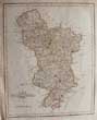
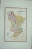
(Code No. 5788)
Cary, John.
(Antique Map).
County map of Derbyshire.
Date. 1st Sep, 1787. 1st edition.
London. John Cary, Arundel Street. Page size 13 x 9 1/2ins]. Original copper engraved hand-coloured map, nicks to left blank margin, not affecting the engraved area.
Taken from John Cary's atlas, New and Correct English Atlas. Beautifully engraved map showing towns, villages, parks, forests, (with each mile numbered) and secondary roads, rivers and canals.. This map repeats Bowen's error of 1751. Cary introduced a new high standard of draughtsmanship and engraving which, coupled with improved cartographical material (due to the numerous recent large-scale surveys of the counties) being available, made this map a great advance on any previous work of its kind....... £35.00
|
Click on picture above to view more images
How to order
|
|
(Code No. 5596)
Jennings, Louis J.
Rambles among the Hills in The Peak of Derbyshire and South Downs.
Date. 1880.
London, Murray. 8vo, [5 1/2 x 8ins]. Pp. xviii. 301, (32 adverts). minor spotting and foxing + 23 Woodcuts by A. H. Hallam Murray. Decorative cloth gilt, slight spotting & fading and very slight chipping to top and bottom of spine...... £50.00
|
Click on picture above to view more images
How to order
|
|
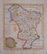
(Code No. 5566)
Bowen, E.
(Antique Map).
Derbyshire Divided into its Hundreds; Containing y. County & Market Towns, Rivers, Roads, etc by Eman: Bowen Geog' to his Maj.
Date. 1761.
London, Image size [6 1/2 x 7 1/4ins]. Original hand-coloured copper engraved map, ( Modern colouring) Below the image, "Engrav'd for the General Magazine of Arts & Sciences; for W. Owen at Temple Bar 1761".....£50.00
|
Click on picture above to view more images
How to order
|
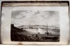
|
(Code No. 5564)Panoramic View of Buxton, (Derbyshire, UK).(Antique coloured print).Date. [c.1870].London, Stationers Hall. Page size, [13 3/4 x 3 1/4ins]. Original hand-coloured steel engraved plate. Listing below and above the image various places of interest:- Hot Baths, The Crescent, The Quadrant, Hotels, etc.....
|
SOLD.
|
|
(Code No. 5538)Baker, Ernest. Moors, Crags & Caves of the High Peak and the neighbourhood ... With forty-three illustrations and two maps.Date. [1903.]Manchester, London, John Heywood. 8vo, Pp. 207 + Illustrations throughout including 2 folding maps. Original pictorial cloth, rubbed.....
|
SOLD.
|
|
(Code No. 5393)Stanford, Edward.(16 Ordnance Survey Maps.)Ordnance Survey for ASHOVER and one ordnance survey map of HOLBROOK in Derbyshire.Sheets nos : - xxx.1 - xxiv.16 - xxix.4 - xix.11- xxix.12 - xxx.9 - xxiv.15 - xxix.16 - xxx.13 - xxxiv.14 - xxx.5 - xxx.6 - xiii.9 - xxxv.1 - xxxv.5 - xxv.13.Surveyed in 1875 to 1897,(approx).Engraved at the Ordnance Survey Office, Southampton. Sectional linen backed Zincographed engraved maps with outline hand-colour. one map damaged. Scale 208.33 feet to 1inch. Map size, 41 x 28 1/2 ins folding to 10 x 14ins. Listing the parishes, parks, railways, roads, boundaries, marches, farms, etc.Ashover was at one time a flourishing business centre, with lead mines, 13 lime kilns, coal at Alton, smelting at Stonedge, lace thread at Kelstedge, four flour mills on the Amber, shoemakers, nailmakers, basketmakers, stocking frames, and rope works which used to spin ropes which reached right across the Moor Road down to the Church gate, claimed to be the longest ropes made in the country, and used for the mines. ...
|
SOLD.
|
|
(Code No. 5389)Lysons, Daniel. Rev, and Samuel.Lysons Magna Britannia: being a Concise Topographical Account of the Several Counties of Great Britain containing DERBYSHIRE.Volume 5.Date. 1817.London, Printed For T. Cadell and W. Davies. 4to, [11 1/2 x 10ins.] Pp. ccxli, 344, some foxing spots + Map + 35 Copper engraved plates, (as listed) + 31 Extra copper engraved plates. A few editions of this work were published incorporating all William Byrne's, engraved plates of Derbyshire, taken from his "Britannia Depicta; a series of views, with brief descriptions, of the most interesting and picturesque objects in Great Britain". Published by Cadell & W. Davies: London, 1806-18, engraved from drawings by Messrs. Hearne, Farington, Smith, Turner, Alexander, &c. By W. Byrne [and others], etc..Lyson's Magna Britannia was published between 1806 -22, the intention was to research and publish the history of every county in England, unfortunately only about 10 counties were completed. Original full calf gilt, later spine...
|
SOLD.
|
|
(Code No. 5387)
Stanford, Edward.
(3 Ordnance Survey Maps.)
Ordnance Survey for HOLMESFIELD in Derbyshire.
Sheets nos : - xvii.5 - xvii.2 - xvii.14.
Date. Surveyed in 1875 to 1897,(approx).
Engraved at the Ordnance Survey Office, Southampton. 3 Sectional linen backed Zincographed engraved maps with outline hand-colour. Scale 208.33 feet to 1inch. Map size, 41 x 28 1/2 ins folding to 10 x 14ins. Listing the parishes, parks, railways, roads, boundaries, marches, farms, etc, for Holmesfield, Baslow, Burnell.... £35.00
|
Click on picture above to view more images
How to order
|
|
(Code No. 5373)Stanford, Edward.(11 Ordnance Survey Maps + Slipcase)Ordnance Survey for STAVELEY in Derbyshire.Sheets nos : - xxv.4 - xix.5 - xix.9 - xix.13 - xxvi.1- xix.10 - xix.14 - xviii.16 - xviii.12 - xviii.8 - xviii.4.Date. Surveyed in 1874 to 5,(approx), Revised again in 1914.Engraved at the Ordnance Survey Office, Southampton . Sectional linen backed Zincographed engraved maps with outline hand-colour. Scale 208.33 feet to 1inch. Map size, 41 x 28 1/2 ins folding to 10 x 14ins. Listing the parishes, parks, railways, roads, boundaries, marches, farms, etc + faint pencil annotations to field names, works, etc, listing the owner's name and rents, etc.. Original slipcase, Poor condition.Staveley is a town within the borough of Chesterfield, in Derbyshire, England. The town is situated alongside the River Rother, adjacent to Eckington to the north, Barlborough to the east, Sutton-cum-Duckmanton civil parish to the south and Brimington to the west. ..
|
SOLD.
|
|
(Code No. 5369)Stanford, Edward.(9 Ordnance Survey Maps + Slipcase)Ordnance Survey for WINGERWORTH in Derbyshire.Sheets nos : -xxv.10 - xxv.9 - xxv.15 - xxv.14 - xxv.13 - xxiv.16 - xxx.1 - xxx.2 & xxx.3.Date. Surveyed in 1877. Revised in 1897.Engraved at the Ordnance Survey Office, Southampton . Sectional linen backed Zincographed engraved maps with outline hand-colour. Scale 208.33 feet to 1inch. Map size, 41 x 28 1/2 ins folding to 10 x 14ins. Listing the parishes, parks, railways, roads, boundaries, marches, farms, etc + faint pencil annotations to field names, works, etc, listing the owner's name and rents, etc.. Showing :- Wingerworth ,Hockley, Wingerworth hall, Avenue Colliery and lime, iron works, Grassmore colliery, Corbriggs,Tupton, etc. Original slipcase, marked with surface loss...
|
SOLD.
|
|
(Code no. 5366)Stanford, Edward.(8 Ordnance Survey Maps + Slipcase)Ordnance Survey for Eckington in Derbyshire.Sheets nos : - xii.7- xii.11- xii.15 - xviii.3 - xii.6 - xii.10 - xii.14 & xviii.2.Surveyed in 1877-9. Revised in 1897Engraved at the Ordnance Survey Office, Southampton . . Reprinted by Direct Helio..... 20/13. Sectional linen backed Zincographed engraved maps with outline hand-colour. Scale 208.33 feet to 1inch. Map size, 41 x 28 1/2 ins folding to 10 x 14ins. Listing the parishes, parks, railways, roads, boundaries, marches, farms, etc + faint pencil annotations to field names, works, etc, listing the owner's name and rents, etc.. Showing :- Eckington, Apperknowle, Gledless, Ridgeway moor, Birley collieries, etc. Original slipcase, marked with surface loss...
|
SOLD.
|
|
(Code No. 5365)Stanford, Edward.(5 Ordnance Survey Maps + Slipcase)Ordnance Survey for Killamarsh in Derbyshire.Sheet nos:- xii.9, xiii.10, xiii.13, xiii.14 & xix.1.Date. [c. 1904.]Engraved at the Ordnance Survey Office, Southampton . Surveyed in 1877-9. Revised in 1897. Reprinted by Direct Helio..... Sectional linen backed Zincographed engraved maps with outline hand-colour. Scale 208.33 feet to 1inch. Map size, 41 x 28 1/2 ins folding to 10 x 14ins. Listing the parishes, parks, railways, roads, boundaries, marches, farms, etc + faint pencil annotations to field names, works, etc, listing the owner's name and rents, etc..Showing :- Spinkhill, Eckington, Apperknowle, Gledless, Ridgeway Moor, Birley Collieries,etc. Original slipcase, marked with surface loss...
|
SOLD.
|
|
(Code No. 4805)Moule, Thomas.DERBYSHIRE.(Antique Map, Guaranteed over 140 yrs old ).Date. [1836 -52.]London. Virtue. Page size 10 3/4 x 8 1/2ins. Steel engraved county map of DERBYSHIRE, nicks to outer margins and strengthened fold on back of map.. Decorated with five vignettes, All Saints Derby and Matlock. Ornamental border with symbolic figures woven into the design and heraldic coat of arms. Moule's county maps are the last series of decorative maps to be published.
|
SOLD.
|
|
(Code No. 4416)
Orme. D.
(Antique Print.)
HADDON HALL.
Buxton. Mr.Orme. Page size [15 x 11ins]. Image size 11 3/4 x 8ins]. 1833. Original engraved lithograph by W. Crane of Chester, very good condition. £50.00.
|
Click on picture above to view more images.
How to order |
|
(Code No. DP4089)Bowen, Emanuel, John Owen, & John, Ogilby.(Antique Map & Strip Road Map.)DERBYSHIRE.London. T, Bowles. King of Spain. 1720-64.. Size of page, 6 x 8 ins. Original copper engraved County map + strip road map, both taken from "Britannia Depicta or Ogilby Improv'd", very good condition.
|
SOLD.
|
|
(Code No. 3939)BADDELEY, M. J. B.(2 Peak District "Through Guides").The Peak District of Derbyshire and the Neighbourhood.London. Dulau. 1894, 6th edn & 1883, 2nd edn. 12mo. Pp xxiv 139 xx & xx 158 86. Maps and illustrations throughout, both 1st folding maps split , no loss. Original cloth gilt, one volume, faded spine.
|
SOLD.
|
|
(Code No. 3609)BYRNE, WILLIAM & Thomas Hearne.(15 Antique Prints of Derbyshire.)Britannia Depicta; A Series of Views . . . in Great Britain. London. Caddel & Davies. 1817. Page Size 17 x 11 1/2 ins. Image size 9 x 6 ins. Beautiful copper engraved view of Derbyshire, (Loose), from original drawings by J.Farington R.A, J.W. Smith, J.M W. Turner, &c. Engraved by F.H. Hays and others. Taken from "Britannia Depicta" this being the Derbyshire section.
|
SOLD.
|
|
(Code No. 3610).London. C, Smith. Jan 6th, 1801, 1st edn. Image size 17 1/2 x 19 1/4 ins. Page size, 20 x 24 1/2 ins. Original hand coloured copper engraved folded, (as published) map. A nicely engraved map, coloured in hundreds, showing towns ( with their distances from London), The main roads are carried across the county boundary and their destination given. It is the first map of the county to be based on the meridian of Greenwich.
|
SOLD.
|
|
(Code No. 3611).London. John Cary. 1811, Apr 28th, 3rd edn. Image size 18 1/2 x 20 1/4 ins. Page size, 21 x 25 1/2 ins. Original hand coloured copper engraved folded (as published) map, nicely engraved , coloured in hundreds, showing towns The main roads are carried across the county boundary and their destination given. The map is based on the meridian of Greenwich. The map's lay out has a remarkable resemblance to the Charles Smith's map of 1801, Cary unfortunately also copied some of Smith's minor errors.
|
SOLD.
|
|
(Code No. 3612).Smith, Charles."A New Map of the County of Derby Divided into Hundreds".London. C, Smith.1818, 3rd edn. Image size 17 1/2 x 19 1/4 ins. Page size, 20 x 24 1/2 ins. Original hand coloured copper engraved folded, (as published) map. A nicely engraved map, coloured in hundreds, showing towns ( with their distances from London), The main roads are carried across the county boundary and their destination given. It is the first map of the county to be based on the meridian of Greenwich.
|
SOLD.
|
|
(Code No. 3613).
Wallis, J.
Map of "Derbyshire".
London. S.A.Oddy. 1812. Image size 7 x 10 1/2 ins. Page size 15 1/4 x 10 ins. Original hand coloured copper engraved map, slight off setting. Showing, distances from London, villages, hundreds (indicated by numbers, and colours). Title in a hatched lozenge crossing a star compass indicator. £35.00
|
Click on picture above to view more images.
How to order |
|
(Code No. 3614). London.Slater, Fleet St. (1846). Image size13 1/2 x 8 1/4 ins.ins. Page size 16 x 11 ins. Original hand coloured steel engraved map, with vignette view of "Ashborn Church." Showing, distances from London, villages, hundreds ( indicated by numbers ). Top centre, a star compass indicator. The adjacent counties are coloured in outline.
|
SOLD
|
|
(Code No. 3555)
Britton John & W. Edward Brayley.
Cumberland + Isle of Man + Derbyshire.
Beauties of England and Wales. Volume 3.
London. Vernor and Hood, 8vo. 1802. Pp. 552 (20) index + Engraved title + 28 Copper engraved plates, slight foxing & damp stain to some corners. Original half calf, rubbed and split to hinges. Binding still holding firm. Between the years 1801 and 1818 the authors undertook a topographical study of England and Wales, travelling many thousand of miles on foot, gathering information for their "Beauties of England and Wales", publishing at regular intervals, county volumes in alphabetical order. £65.00
|
Click on picture above to view more images
How to order |
|
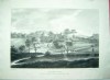
(Code No. 3513)
Boydell. J.
( Antique Print )
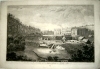
"A View of Matlock Bath, in Derby Shire".
London. J. Boydell. 1749. Image size 17 1/2 x 11 1/4 ins. Page size 21 1/2 x 14 ins. Original copper engraved plate, drawn and engraved by J. Boydell, vg. Guaranteed to be over 250 years old....... £200.00
|
Click on picture above to view more images
How to order
|
|
Return to top
|
|