SITE CONTENT
Antique Maps & Prints
Britain
Antique Maps - World
Antique Books
Cartographers
Early Prints
Other Stock
|
| Maps, Prints and Books of South West England |
Images |
(Code No. 6800)
Grose. Francis,
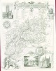
(ANTIQUE MAP)
HEREFORDSHIRE.
Date. [c.1780].
London. Approx size 250mm x 170mm, Original copper engraved map, with descripitive text below the map. The map is a reprint of John Seller's map, dated 1701, from [Camden's Britannia abridged, J. Wild]........ £25.00 |
Click on picture above to view more images
How to order |
(Code No.6498)
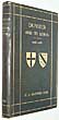
Lyte, (Henry C. Maxwell) Sir.
Dunster and its Lords, 1066-1881 ... With a descriptive sketch of Dunster Castle, by G. T. Clark ... and a chapter on the siege and surrender of Dunster Castle, by E. Green.
Limited to 200 copies.
Date. 1882.
Exeter, Printed for Private Circulation. 4to, [10 1/4 x 7ins]. Pp. xv, 145, [1] + 42 engraved prints, slight foxing. Original cloth gilt, slight chipping to top and bottom of spine.
Dunster is one of the most perfectly preserved medieval villages in England, with its origins dating back to the times of Bronze and Iron Age Britain. Dunster still retains it's original charm and atmosphere, and continues to be an important focal point for people coming to West Somerset with the Castle alone having well over 100,000 visitors each year.The buildings and constructions that make up the heritage of Dunster have, in recent years, been well preserved and protected either by their owners or sympathetic conservation bodies and organisations....£110.00 |
Click on picture above to view more images
How to order |
(Code No. 6494)
Cameron, C. P. (Photographer).
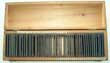
50 MAGIC LANTERN GLASS SLIDES of DEVON, titled:- "A holiday ramble in South Devon"
Date. [c.1890].
. England, Plate size 3 1/4 x 3 1/4ins. 50 Glass Magic lantern slide photographs of Marldon, Shaldon, Teignmouth, Watcome Cliff, Babbacombe, Torquay, Anatey's Cove, Cockington, Exeter, etc. Titled in ink. Housed in the original wood box. Heavy item...... £140.00 |
Click on picture above to view more images
How to order |
(Code No. 6455)
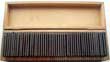
Cameron, C. P. (Photographer).
50 GLASS MAGIC LANTERN SLIDE PHOTOGRAPHS of DEVON.
Date. [c.1890].
England, Plate size 3 1/4 x 3 1/4ins. 50 glass lantern slide photographs of Longcome, Berry Pomeroy, Totnes, Staverton, Dittishham Ferry, Dartmouth, Kingswear, River Dart, Brixham Fishing Fleet, Brixham, etc. Titled in ink. Housed in the original wood box. Heavy item.............. £140.00 |
Click on picture above to view more images
How to order |
(Code No. 6443)
Cameron, C. P. (Photographer).
50 GLASS MAGIC LANTERN SLIDE PHOTOGRAPHS of DEVON.
Date. [c.1890].
England, Plate size 3 1/4 x 3 1/4ins...50 Glass lantern slide photographs of Paignton, Brixham, Plymouth, Saltash, Ivybridge, etc. Titled in ink. Housed in the original wood box. Heavy item...... £140.00. |
Click on picture above to view more images
How to order |
(Code No. 6332)
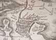
Hollar, Wenceslas.
(Antique Print).
A Trve Mapp and Discription of the Towne of Plymouth and the Fortifications thereof with the workes and approaches of the Enemy at the last Siege AD 1643.
Date. No publishing date. [c.1670].
London. Page size, [15 x 11 1/2ins]. Original copper engraved etching, slight nicks into engraved area and creased edges.
Plan of Plymouth and the Sound, with ships, and strategic positions of troops during a siege in 1643, scale bar below, tablet at top right.
.......
£200.00 . |
Click on picture above to view more images
How to order |
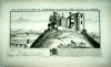
(Code No. 6322)
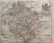
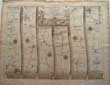
Read, Thomas.
Map of HEREFORDSHIRE + Text.
Date. 1743-46.
London. Page size, [8 1/4 x 7ins]. Pp. 217-250 + Original copper engraved folding map of Herefordshire by Thomas Read.
The county maps with a topographical description were published alphabetically in weekly parts, 1743-46 by Thomas Read. Only 29 county maps in three volumes have been located up to the county of Shropshire. The fourth volume does not appear to have been traced. Volume four must have at some time been published because John Rocque was able to acquire the complete set of 52 plates in about 1750, updating some the maps with an altered scale bar. The Read maps + text are very rare, the John Rocque reprint less so...... £100.00 |
Click on picture above to view more images
How to order |
(Code No. 6205)Treves, Frederick.Highways and Byways in Dorset.Date. 1914.London, Macmillan. 8vo, [5 1/2 x 8ins]. Pp. xviii, 376, [4 adverts] + Illustrations throughout by Joseph Pennell. Original cloth gilt. Fine copy. .......
|
SOLD.
|
(Code No. 6123)
Hamilton-Jenkin, A. K.
THE CORNISH MINER.
An Account of his Life above and Underground from Early Times.
Date. 1972.
Newton Abbot, David & Charles. 8vo, Pp.351 + Illustrations throughout. Original cloth gilt. Dust jacket, very good....... £30.00 |
Click on picture above to view more images
How to order |
(Code No. 6118)
Ansted, David Thomas, (edit).
Black's Guide to the Channel Islands.
Date. 1872.
London, Adam and Charles Black. 12mo. Pp.viii, 188, [72 adverts] + 5 maps + 16 full page & text illustrations throughout. Original cloth gilt, very slight rubbing........ £35.00 |
Click on picture above to view more images
How to order |
(Code No. 6081)
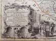
BOWEN, Emanuel & Kitchin Thomas.
(Large Antique Map).
An Improved Map of the County of SOMERSET.....
Date. [c.1760].
London, Carrington Bowles, Robert Sayer, and John Bowles. Page size [30 x 23ins]. . Original outline hand-coloured copper engraved double page map, slight fold splits. Scale about 4 miles to 1 inch, The largest of the county map to date and incorporating many new details, but also introducing some curious errors. The degrees of longitude (West of London) are about 2 degrees out and the main body of the counties are too wide from east to west. They show towns with their market days, villages (with indications to show whether rectory or vicarage), religious houses, charity schools, castles, hundreds, hills, parks, forests, sands, meres, rivers, brooks, post roads with measured distances between the towns, and several other roads now shown for the first time. Numerous descriptive notes are scattered around the map. A circular compass indicator. The title with the imprint below, scale, "Explanation" (of the symbols on the map), and the dedication. The titles have a pictorial surround.
Thomas Kitchin was an engraver and publisher at The Star opposite Ely Gate, Holborn, and London from 1738 to 1776. He was a prolific producer of maps, plans and charts, and was by appointment Hydrographer to the King - George III. His output included sheet maps, series of maps for the Universal Magazine and the London Magazine, and atlases. He worked with Thomas Jefferys and particularly with Emanuel Bowen....... £250.00 |
Click on picture above to view more images
How to order |
(Code No. 6060)Down, C. G. & A. J. Warrington.The History of the Somerset Coalfield.Date. [c.1970].Newton Abbot, David & Charles. 8vo, [6 x 9ins]. Pp. 283 + Illustrations throughout, very good condition. Dust jacket, very good condition.The Somerset coalfield stretched from Cromhall in the north to the Mendip Hills in the south, and from Bath in the east to Nailsea in the west, a total area of about 240 square.......
|
SOLD.
|
(Code No. 6042)Messenger Michael J.Caradon and Looe:The Canal, Railways, and Mines the History of the Liskeard & Looe Union Canal, the Liskeard & Caradon Railway, the Liskeard & Looe Railway, and the Mines and Industries they Served.Date. 1978.Truro, Twelveheads Press. 8vo, [7 1/2 x 9 1/2ins]. Pp. 128 + Illustrated throughout. Original cloth gilt. Dust Jacket, very good. This book, which is the first definitive history of these transport systems, fill an important gap in Cornish industrial and railway history and firmly relates the railways, canal and mines to each other........
|
SOLD.
|
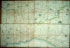
(Code No. 6024)
Ogilby. John.
( Antique Strip Road Map).
The Road from Oxford to Bristol. -- Oxford to Faringdon, Highworth, Purton, Malmsbury, Luckington, Puckle Church and ending at Bristol.
Date. 1675.
London. Page size, (approx), [ 20 1/4 x 16 ins ]. Image Size [ 17 x 13ins ]. Original copper engraved Strip Road Map by John Ogilby, very good condition.
Each map strip shows towns, villages, mansions with owner's name, castles, wind mills, beacons, gallows, woods, rivers, and hills etc. Elaborate title cartouche and compass roses to each map strip. John Ogilby was a topographer, printer, and map-maker, born in Edinburgh, EC Scotland, UK. A dancing teacher and theatre owner, he lost everything in the Civil War, but after the Restoration obtained court recognition and became a London publisher. The great fire of 1666 destroyed his stock but got him the job of surveying the gutted sites in the city. He established a thriving printing house and was appointed 'king's cosmographer and geographic printer'. His most important publications were engravings of maps and atlases, including Africa (1670), America (1671), and Asia (1673), and a road atlas "Britannia" (1675), unfinished at his death. He was also the first cartographer to adopt the statute mile. Scale 1inch to the mile, each mile is divided into furlongs indicated by dots in the centre of the road. Guaranteed to be over 300 years old........ £140.00 |
Click on picture above to view more images
How to order |
(Code No. 6017)
ANSTEY, Christopher. [1724 - 1805].
An Election Ball,
in poetical letters from Mr. Inkle.
Date. 1776, 3rd edn.
Bath, S. Hazard. 4to, [7 1/2 x 9 1/2ins]. Pp. 64 + Copper engraved frontis by C.W. Bampfylde, frayed edges.
An Election Ball consists of a series of letters from Mr. Inkle to his wife Dinah, currently at Gloucester, describing a 1775 ball given to celebrate Sir John Sebright's re-election to Parliament as member for Bath. Inkle is scarcely a member of polite society, but he would very much like to become one. We see the foibles eccentricities of Bath society through his eyes. Later soft covers........ £125.00 |
Click on picture above to view more images
How to order |
(Code No. 6001)Dines, H G.2 Volumes.THE METALLIFEROUS MINING REGION OF SOUTH-WEST ENGLAND.Date. 1956. London, Her Majesty's Stationery Office. 4to, [6 1/2 x 10ins]. Pp. 795 + Illustrations & maps throughout, Original cloth, very good. Dust wrappers, slight chipping to top of spines.An in-depth report on the geology and mines of Cornwall, and Devon......
|
SOLD.
|
(Code No. 5960)Collins, Greenvile, 1669-1698.Chart of PLYMOUTH.Dedication: To. Arthur Earle Torrington Baron Herbert of Torbay ....... Admiral of their Ma'jies Navy & Capt. Gen'll of the Narrow Seas humbly dedicated by Cpt. G. Collins, Hydrogr' to the King.Date. [c.1745].London, Printed for W. and J. Mount and T. Page. Original copper engraved sea chart, (modern colouring), of Plymouth and Salcombe, in southern England showing Plymouth Sound and coastal features.Title with decorative cartouche. Depth shown by soundings. Plate 16 from: Great Britain's coasting pilot........
|
SOLD.
|
(Code No. 5951)Moule, Thomas.CORNWALL.(Antique Map. Guaranteed over 140 yrs old ).Date. 1836 -52.London. Virtue. Size [10 1/2 x 8 1/2ins.] Steel engraved hand-coloured county map of CORNWALL, very good. Vignette view of Lands End with a inset map of Silly Isles. Ornamental border. Three heraldic coats of arms and the Seal of Saltash.Moule's county maps are the last series of decorative maps to be published. ..
|
SOLD.
|
(Code No. 5892)Ellis, Hamilton.The South Western Railway Its Mechanical History and Background 1838-1922.Date. 1956.London, George Allen & Unwin. 8vo,[6 x 9ins]. Pp. 256 + Illustrations throughout. Original cloth gilt. Dust jacket, very good.South Western Railway's mechanical history, with which this book is engaged, was outstanding; it was served by a succession of brilliant locomotive engineers; it was a pioneer of automatic signalling; all-round quality distinguished its train service and its rolling stock.....
|
SOLD.
|
(Code No. 5789)
Cary, John.
(Antique Map).
County map of SOMERSETSHIRE.
Date. 1st Sep, 1787. 1st edition.
London. John Cary, Arundel Street. Page size 13 x 9 1/2ins]. Original copper engraved hand-coloured map, nicks to blank margin, not affecting the engraved area.
Taken from John Cary's atlas, New and Correct English Atlas. Beautifully engraved map showing towns, villages, parks, forests, (with each mile numbered) and secondary roads, rivers and canals.. This map repeats Bowen's error of 1751. Cary introduced a new high standard of draughtsmanship and engraving which, coupled with improved cartographical material (due to the numerous recent large-scale surveys of the counties) being available, made this map a great advance on any previous work of its kind...... £35.00 |
Click on picture above to view more images
How to order |
(Code No. 5769)Earl, Bryan.Cornish Mining,The Technique of Metal Mining in the West of England, Past and Present.Date. 1968.Truro. D. Bradford Barton Ltd. 8vo, [6 x 9ins]. Pp. 118 + Illustrations throughout. Original cloth gilt. Dust jacket,
|
SOLD.
|
(Code No. 5768)Barton, R.M.A History of the Cornish China-Clay Industry.Date. 1966.Truro. D. Bradford Barton Ltd, 8vo, Pp. 212 + Illustrations throughout. Original cloth gilt. Dust jacket, slight rubbing & chipping top edge. .......
|
SOLD.
|
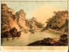
(Code No. 5711)
Anon.
(Antique Print).
Lynmouth.
Date. [c.1840].
England . Page size [11 x 8ins]. Image size [10 1/2 x 7 1/4ins]. Original lithographic engraved print, damage to corner. Rare print...... £50.00. |
Click on picture above to view more images
How to order |
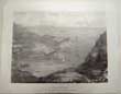
(Code No. 5710)
Anon.
(Antique Print).
Lynmouth, Devon.
Date. [c.1840].
England . Page size [11 x 8ins]. Image size [9 x 6 1/4ins]. Original lithographic engraved print. Rare print...... £60.00 |
Click on picture above to view more images
How to order |
(Code No. 5709)
Anon.
(Antique Print).
Ilfracombe.The Brighton of the north of Devon. Lighthouse in a Storm.
Date. [c.1840].
England . Page size [11 x 8ins]. Image size [9 x 7ins]. Original lithographic engraved print. Rare print....... £40.00 |
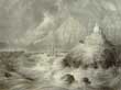
Click on picture above to view more images
How to order |
(Code No. 5708)
Anon.
(Antique Print).
Ilfracombe.The Brighton of the north of Devon. View of the Town & Harbour.
Date. [c.1840].
England . Page size [11 x 8ins]. Image size [9 x 7ins]. Original lithographic engraved print, nick extending 1/2in into engraved area. Rare print.....£60.00 |
Click on picture above to view more images
How to order |
(Code No. 5592)Buck, Samuel (& Nathaniel).( Antique Print).The North East View of Nunye Castle ( Nunney Castle, Frome,) in the County of Somersetshire.Date. 1733,1st edition.London. Image size 14 x 7 1/2ins. Original copper engraved print drawn and engraved by Samuel & Nathaniel Buck, nicks just affecting the engraved surface.The brothers, Samuel and Nathaniel Buck drew and engraved a series of etched panoramas of British towns, castles and abbeys etc including the history of the castles. Print numbered 6 in the left hand blank margin, signifying that it is the 1st edition, not the laterer 18 Century reprints. Nunney Castle is a small, French style castle surrounded by a deep moat, built for Sir John Delamare in 1373. A veteran of the Hundred Years War, Sir John would later become Sheriff of Somerset. During the Civil Wars (1642-51) Cromwell's men used cannon to blast a great hole in the north wall of the castle, forcing the garrison to surrender. The badly damaged wall finally collapsed in 1910. .....
|
SOLD.
|
(Code No. 5535)Chilcott's Descriptive History of Bristol, Ancient and Modern; Or, A Guide to Bristol, Clifton, & The Hotwells ; With Topograhical Notices of the Neighbouring Villages, Etc.Date. [c.1849].Bristol, J. Chilcott. 8vo, [5 x 7ins.] Pp. 429 + Engraved frontis + 3 folding maps + Engraved woodcut plates, one folding, Original cloth, with printed title, Spine faded and slight split to cloth hinges. Holding firm....
|
SOLD.
|
(Code No. 5498)Davies, B. R.(Antique Map.)Map of CORNWALL.Date. [c.1830.]London, Page size, (approx), [11 x 8ins.] Original steel engraved hand-coloured map, drawn and engraved by B. R. Davies. Vignette of Cheese Wring and 2 inset maps of Scilly Isles, and Continuation of the North Part....
|
SOLD.
|
(Code No. 5401)Thomas Hearne (1744 – 1817).(Antique Print).An Oak in Moccas Park, Herefordshire.Date. 2nd June 1798London, W. Lowry, Page size [15 1/2 x 10 1/2ins]. Image size [10 x 7 1/2ins.] . Original copper engraved plate by B, T Pouney, creasing to outer edges.Described in Rev Kilvert's diary as "those grey old men of Moccas, those grey, gnarled low-browed, knockneed bowed bent, huge, strange long-armed deformed hunchback misshapen oak men that stand waiting and watching century after century". Moccas Deer Park, part of the Chester-Master Estate and one of the most important sites of surviving woodland pasture in the country, which is still home to a herd of deer and the Moccas beetle, Hypebaeus flavipes, is so rare that it occurs only at one place in the world: on the ancient oaks at Moccas Park...
|
SOLD.
|
(Code No. 5347)
Anon.
The Rivers of Great Britain, Descriptive, Historical, Pictorial Rivers of the South and West Coasts.
Date. 1897.
London, Cassell and Company Ltd. Small folio, [10 x 12 1/2ins.] Pp. viii, 376 + Illustratoins throughout. Original cloth gilt, spine faded & chipping to top of spine. All edges gilt. £45.00 |
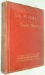
Click on picture above to view more images
How to order
|
(Code No. 5167)Moll. Herman.( Antique Map)Cornwall.Date.1724.London. H. Moll. Page size (approx), [302 x 190 mm]. Image size, (approx), [345 x 220 mm]. Original copper engraved hand-coloured map of Cornwall by H. Moll, slight nicks to edges. Oblong title panel, scale, list of Hundreds, graduated border and to the right and left borders Roman alters and amethyst fibulae found in Cornwall. Roads are according to John Ogilby's survey of 1675..
|
SOLD.
|
(Code No. 5161)Moule, Thomas.DORSETSHIRE.(Antique Map, Guaranteed over 140 yrs old ).Date 1836 -52London. Virtue. Size 270 x 215 mm. . Steel engraved coloured county map of DORSETSHIRE. (Modern colouring), decorated with vignette of Shaftebury, Ornamental border with symbolic figure woven into the design, heraldic coat of arms. Nicks to blank margin not affecting engraved area. Moule's county maps are the last series of decorative maps to be published.
|
SOLD
|
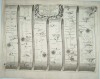
(Code No. 5118).Ogilby. John.( Antique Road Map).The continuation of the Road from London to Bristol, travelling through Marlborough, Calne, Chippenham, Marshfield, Bristol, Axbridge, Huntspill.Map number 11.Date 1675 - 98London. . Page size [ 18 x 13 ins ]. Image Size [ 17 x 12.6 ins ]. Copper engraved hand coloured Strip Road Map, Map damaged with slight image loss. Each map strip shows towns, villages, mansions with owner's name, castles, wind mills, beacons, gallows, woods, rivers, and hills etc. Elaborate title cartouche and compass roses to each map strip.John Ogilby was a topographer, printer, and map-maker, born in Edinburgh, EC Scotland, UK. A dancing teacher and theatre owner, he lost everything in the Civil War, but after the Restoration obtained court recognition and became a London publisher. The great fire of 1666 destroyed his stock but got him the job of surveying the gutted sites in the city. He established a thriving printing house and was appointed 'king's cosmographer and geographic printer'. His most important publications were engravings of maps and atlases, including Africa (1670), America (1671), and Asia (1673), and a road atlas "Britannia" (1675), unfinished at his death. He was also the first cartographer to adopt the statute mile. Scale 1inch to the mile, each mile is divided into furlongs indicated by dots in the centre of the road.
|
SOLD.
|
| (Code No. 4887)Badeslade, Thomas & W.H Toms.Cornwall.(Antique Map.)Date. 29th Sept 1742.London. W. H. Toms in Union Street. Page size [6 1/4 x 6 1/4ins.] Original copper engraved hand-coloured map from a drawing by T Badeslade and engraved by W.H Toms.Taken from the atlas Chorographia Britanniae. The atlas was reprinted in 1742 (several times), 1743, 1745 and about 1747.
|
SOLD.
|
| (Code No. 4849)Moule, Thomas.CORNWALL.(Antique Map, Guaranteed over 140 yrs old ).Date. 1836 -52.London. Virtue. Size [10 1/2 x 8 1/2ins.] Steel engraved county map of CORNWALL. Marked in blank margin. Vignette view of Lands End and an inset map of Silly Isles. Ornamental border, Three heraldic coats of arms and the Seal of Saltash. Moule's county maps are the last series of decorative maps to be published.
|
SOLD.
|
| (Code No. 4816)
Moule, Thomas.
Gloucestershire.
(Antique Map, Guaranteed over 140 yrs old ).
Date. [1836 -52.]
London. Virtue. Page size 10 3/4 x 8 1/2ins. Original steel engraved county map of Gloucestershire, strengthened fold on back of map. decorated with vignettes, view of Gloucester Cathedral, Cheltenham Spa and Tewkesbury Abbey,. Ornamental border with symbolic figures woven into the design, heraldic coat of arms. Moule's county maps are the last series of decorative maps to be published. £30.00
|
Click on picture above to view more images
How to order
|
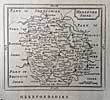
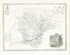
| (Code No. 4809)Moule, Thomas.HEREFORDSHIRE.(Antique Map, Guaranteed over 140 yrs old ).Date. [1836 -52.] London. Virtue. Page size 10 3/4 x 8 1/2ins. Original steel engraved hand coloured county map of Herefordshire. decorated with vignettes, view of Hereford and Goodrick Castle. Ornamental border with symbolic figures woven into the design, heraldic coat of arms. Moule's county maps are the last series of decorative maps to be published.
|
SOLD.
|
| (Code No. 4793)
Moule, Thomas.
DEVONSHIRE.
(Antique Map, Guaranteed over 140 yrs old).
Date. [1836 -52.]
. London. Virtue. Page size 10 3/4 x 8 1/2ins. Original steel engraved county map of DEVONSHIRE, marked to fold area & strengthened on back of map. Decorated with vignette of Guildhall Exeter, heraldic coat of arms, and ornamental border. £30.00
Moule's county maps are the last series of decorative maps to be published.
|
Click on picture above to view more images
How to order
|
| (Code No. 4792)Daniell, William R. A. [1769-1837].Bridport Harbour, Dorset.Date. 1825.London. Daniell. Image size 9 1/2 x 6 3/4. Original aquatint print, drawn and engraved by William Daniell, slight foxing spots & mounted on cardboard. Taken from "A Voyage round Great Britain" No 269. Volume 3. William Daniell commenced a tour in a rowboat around Great Britain in the summers of the years 1813-16 starting and ending at Lands'-End in Cornwall. As he went he drew a series of 308 hand coloured sketches illustrating the character and prominent features of the coast. During the winter times he returned home to produce watercolours and aquatints.
A magnificent series of plates, almost all of equal quality. Valuable as a record and exquisite in its presentation. It is the most important plate book on British Topography.
|
SOLD.
|
| (Code No. 4769)Samuel Lysons. 1763-1819.Etchings of views and antiquities in the County of Gloucester, hitherto imperfectly, or plates never engraved.Date. 1791[-1798].London printed by A. Strahan; and sold by T. Cadell, B. White and Son. Folio,[17 x 12 1/2ins.] 77 Aquatint and etched plates on 51 leaves, (incomplete), with the accompanying letterpress description, including 3 plates with original hand colour, marginal water stains and nicks to outer edges. This extremely rare work is never found complete, possibly the financial costs involved with publication. A few copies of this incomplete edition were eventually sold to subscribers. Original trade boards, some leaves loose.
|
SOLD.
|
| (Code No. 4766)
Anon.
(2 Antique Prints.)
A View of the Hot Wells Bristol and a View of St Vincent Rock, & Clifton.
London? Image sizes [11 x 7 1/4ins.] [c.1800.] 2 Original hand tinted, (2 colours), etched engraved plates, Hot Wells print cropped to right side with mark top centre. £60.00
These prints record views that were lost in 1831, when construction began on the Isambard Brunei's Clifton Suspension Bridge, begun in 1832 and completed in 1864, it now spans the Avon Gorge from the top of St. Vincent's Rock.
|
Click on picture above to view more images
How to order
|
| (Code No. 4614)Senex, John.(Antique strip road map.)The Road from Alresford to Pool in Dorset & Shrewsbury to Holyhead, Anglesey, (printed on a single sheet, No.97& 98). Actually Surveyed by a Wheel ...Date. 1757.London. John Bowles and Son, The Black Horse, Cornhill, London, Page size 9 x 7 1/4ins. Original copper engraved strip map, road map, hand coloured engraving, scale about 2-2.5 miles to 1in by J. Senex. First perform'd and publish'd by John Ogilby, Esqr; And now improved, very much corrected, and made portable by John Senex. Senex's two volume road atlas was much smaller than Ogilby's "Britannia" and would fit into a traveller's pocket.
|
SOLD.
|
(Code No. 4470)Burlington, Charles.A View of the Town and Harbour of PORTSMOUTH.Date. Ca1790. London. J. Cooke. Page size,14 x 9ins. Ca1790. Original copper engraved view, slight foxing to margins well away from engraved area. . The view shows people and horseriders in the foreground and looking towards shipping and the town. This print is guaranteed to be over 200 yrs old.
|
SOLD.
|
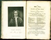
(Code No. 4419)
Fosbrooke .T.D. Rev.
The Wye Tour, or Gilpin on the Wye, with Historical and Archaeological Additions, especially illustrations of Pope's Man of Ross.
Date. 1818.
Ross: W. Farror. 12mo, [4 1/2 x 6 1/2ins.] 1818. Pp. x, viii, 154, including portrait frontis. + map, very good condition. edges untrimmed. Dedication on front end paper. Original trade boards with printed paper label, some chipping. £90.00
|
Click on picture above to view more images
How to order |
(Code No. 4383)Brayley, Edward.DEVONSHIRE & DORSETSHIRE.Volume 4.London. Vernor and Hood, 8vo. 1803. Pp.560, (21) index, Engraved title + 31 Copper engraved plates, slight foxing. Original half calf gilt, rubbed and split to hinges with some surface loss. Binding still holding firm. Between the years 1801 and 1818 the authors undertook a topographical study of England and Wales, travelling many thousand of miles on foot, gathering information for their "Beauties of England and Wales", publishing at regular intervals. Counties listed in alphabetical order.
|
SOLD.
|
(Code No. 4378)Serres, John Thomas, 1759-1825. & R. Bougard.( Antique Print of the coastal profiles of the Cornwall Coast).The Little Sea Torch: or, true guide for coasting pilots: by which they are clearly instructed how to navigate along the coasts of England.....Date. 1801.London . J. T. Serres. 1801. Image size 9 x 15ins. Page size 17 1/2 x 11ins. Original hand coloured engraved aquatint print, by John Luffman, comprise Devon coastal views and plans of ports, views of headlands and lighthouses together with harbours, etc. Showing - Lizard Point, Falmouth, Dodman Point and Mavagezzey Bay..This map is one of twelve sheets in the SERRES, J. T. re issue of " The Little Sea Torch, or True Guide for Coasting Pilots: by which they are clearly instructed how to navigate along the coasts of England,
|
SOLD.
|
(Code No. 4377)Serres, John Thomas, 1759-1825. & R. Bougard.( Antique Print of the coastal profiles of the Devon Coast).The Little Sea Torch: or, true guide for coasting pilots: by which they are clearly instructed how to navigate along the coasts of England.....London . J. T. Serres. 1801. Image size 9 x 15ins. Page size 17 1/2 x 11ins. Original hand coloured engraved aquatint print, by John Luffman, comprise Devon coastal views and plans of ports, views of headlands and lighthouses together with harbours, etc. Showing - Prall Point, Bolt Tail, Love Island, Bigbury Bay, Borough Island to Stoke point. This map is one of twelve sheets in the SERRES, J. T. re issue of " The Little Sea Torch, or True Guide for Coasting Pilots: by which they are clearly instructed how to navigate along the coasts of England,
|
SOLD.
|
(Code No. 4371)
Ogilby. John.
( Antique Road Map).
London to St Davids.
Date 1675 - 98.
Map number. 70. London. Leaf size [ 19 x 15 ins ]. Image Size [ 18 x 12 3/4 ins ]. Copper engraved Road Map. Each map strip shows - towns, villages, mansions with owner's name, castles, wind mills, beacons, gallows, woods, rivers, and, hills etc. Elaborate title cartouche and compass roses to each map strip. £170.00
John Ogilby was the first cartographer to adopt the statute mile. Scale 1inch to the mile, each mile is divided into furlongs indicated by dots in the centre of the road. Map route - Abingdon, Fairford, Barnsley, Brimsfield, Gloucester & Monmouth, Guaranteed to be over 275 years old.
|
Click on picture above to view more images
How to order |
(Code No. 4164)Wreford J.K.R, Dr.Curiosities Of Bristol and Its Neighbourhood.A Guide, For The Use Of Strangers.Bristol. Mathews. July, 1854. 8vo, [245 x 160mm.] Pp viii 80 + Full-page illustration + Tipped-in contemporary news paper cuttings, some foxing. Original half morocco, over marbled boards, rubbed with slight loss. The book deals with the history, prominent families, directory, etc, of Bristol. It was issued monthly for eleven month at three half pence each, then ceasing publication. This book is complete with the eleven monthly parts.
|
SOLD.
|
(Code No. 4086 DP)Bowen, Emanuel, John Owen, & John, Ogilby.(Antique Map & Strip Road Map).HEREFORDSHIRE.London. T, Bowles. King of Spain. 1720-64.. Size of page, 6 x 8 ins. Original copper engraved County map + strip road map, both taken from "Britannia Depicta or Ogilby Improv'd", very good condition.
|
SOLD.
|
(Code No. 4079 DP)Bowen. Emanuel, John Owen & John, Ogilby.(Antique Map & Strip Road Map.)SOMERSETSHIRE.London. T, Bowles. King of Spain. 1720-64.. Size of page, 6 x 8 ins. Original copper engraved County map + strip road map, both taken from "Britannia Depicta or Ogilby Improv'd", very good condition. £40.00
|
SOLD.
|
(Code No. 4051)
Buck. Samuel and Nathaniel.
(Guaranteed Antique Print.)
South-East View of Tamworth-Castle, in the County of Warwick.
Date ca1770. Page size 17 1/2 x 10 1/2 ins. Image size 14 x 7 1/2 ins. Copper engraved print, laid on to card. The brothers, Samuel and Nathaniel Buck made a series of etched panoramas and views of British towns, castles and abbeys. This engraving describes the history of the castle, from Norman times and the numerous changes of ownership, below the image. Dedicated to, James, Earl of Northampton. £40.00
|
Click on picture above to view more images
How to order |
(Code No. 3989)
Stanford, Edward, [1827-1904].
Four one inch Ordnance Survey Maps of the South Coast of Dorsetshire and Devonshire.
Edward Stanford, 26 & 27 Cockspur St., Charing Cross, S.W., No Date ca1880. 4 Dissected, linen backed hand coloured maps;38 x 25 1/2 ins, approx. 19 x 12 1/2 ins each, folded in cover to 4 x 6 3/4 ins. Approx areas shown, Sidmouth to bottom left, Bathealton top left, Corton Denham top right and Abbotsbury bottom right. Sheets 311, 312, 326 and 327. (Complete square). 3 Piano key borders. Slip-case, poor. £65.00
|
Click on picture above to view more images
How to order |
(Code No. 3335)Covens, J. & Mortier, C.( Antique Print )The Landing of William of Orange at Brixham, 5th of November 1688. "Vertrek van S.K.H. Na Engeland"Date. [c.1725].Amsterdam. Cóvens & Mortier, , Page size 23 1/2 x 18 1/2 1ns. Original folding copper engraved plate by R. de Hooge. French & Dutch text, very good condition. The view is in two parts.
Named war ships laying at anchor, and the provisions, cattle, horses etc, being brought ashore, The locations of Exeter, Brixham and Taunton are indicated.
|
SOLD.
|
(Code No. 3452).
CARY, J. (Antique Map)
A Map of WARWICKSHIRE from the best Authorities.
London. John Stochdale. 28th March 1805. Page size 22 1/2 x 17ins, image size 20 1/2 x 16 1/4 ins. Pp 443 to 467 + Copper engraved folding map engraved by John Cary taken from Camden's Britannia.
Map showing town, village,hundreds (indicated by numbers), meres, turnpike etc. Elaborate star compass indicator. "Reference to the Hundreds" and scale and title. No covers. £70.00
|

Click on picture above to view more images
How to order |
(Code No. 3424).Moule. Thomas,WORCESTERSHIRE. (Antique Map, Guaranteed over 140 yrs old ).London. Virtue. Date 1836 -52. Size 270 x 215 mm. Steel engraved coloured county map of WORCESTERSHIRE. (Modern colouring), decorated with vignettes of Great Malvern,Worcester and Croom Court.
Ornamental border with symbolic figure woven into the design, heraldic coat of arms. Moule's county maps are the last series of decorative maps to be published.
|
SOLD.
|
(Code No. 3425).
Moule, Thomas.
DEVONSHIRE. (Antique Map, Guaranteed over 140 yrs old ).
London. Virtue. Date 1836 -52. Size 270 x 215 mm. Steel engraved coloured county map of DEVONSHIRE. (Modern colouring), decorated with vignette of Guildhall Exeter.Ornamental border. Heraldic coat of arms. Center fold.
Moule's county maps are the last series of decorative maps to be published. £50.00
|
Click on picture above to view more images
How to order |
(Code No. 3373)
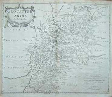
MORDEN, (Robert). [Antique Map]:
County map of GLOUCESTERSHIRE.
London. Swale, Awnsham and Churchill. 1695 1edn. Size of map 17 x
15 ins. Original double page copper engraved county map of Gloucestershire
by Robert Morden, based on John Speed's map. Three 10-mile scales
(62, 70 and 73 miles =1' Lat = 16 ins). Shell-type cartouche containing
the title and Morden's name. The maps have graduated borders. Taken
from Camden's Britannia of 1695, vg. £110.00 |
Click on picture above to view more images
How
to order |
| (Code No: 2642) Arnhem. 1607 or later edition. Image size 180 x 125 mm. Copper
engraved map of Cornwall, Devon and Somerset etc, by G. Mercator
, vg. A reduced version of Mercator's map of 1595. Superb ornate
title and scale cartouche, watered-silk rendering of the sea. Two
sail ships, vg. From the "Atlas Minor". |
SOLD
|
| (Code No. 3250)London. ca1850. Page size 15 x 11 ins. Original single page steel
engraved Town Plan of PLYMOUTH drawn and engraved by J. Watkins, the
plan drawn by J. Rapkin + 3 vignette views of Plymouth Sound, Plymouth
and The Column. Slight foxing to border. |
SOLD
|
Return to top
|
|