SITE CONTENT
Antique Maps & Prints
Britain
Antique Maps - World
Antique Books
Cartographers
Early Prints
Other Stock
|
| Maps, Prints & Books of South East England |
Images |
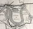
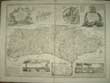
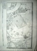
(Code No. 6930)
Bazalgette, Joseph.
(Antique print).
Plan and sections of the great Metropolitan Sewage drains, North & South of the Thames.
Date. (c.1850).
London, Guildhall, Clark's Office. Page size. [16 x 10 1/2ins] Original plan of the great Metropolitan Sewage System, London. Taken from the Pictorial Times.
The Great Stink was an event in central London in July and August 1858 during which the hot weather exacerbated the smell of untreated human waste and industrial effluent that was present on the banks of the River Thames. The problem had been mounting for some years, with an ageing and inadequate sewer system that emptied directly into the Thames. The miasma from the effluent was thought to transmit contagious diseases, and three outbreaks of cholera prior to the Great Stink were blamed on the ongoing problems with the river. Joseph Bazalgette was appointed to the position of assistant surveyor. He had been working as a consultant engineer in the railway industry his appointment to the commission was his first position on his return to employment. Working under the chief engineer, Frank Foster, he began to develop a more systematic plan for the city's sewers. The stress of his position was too much for Foster and he died in 1852; Bazalgette was promoted into his position, and continued refining and developing the plans for the development of the sewerage system........ £40.00 |
Click on picture above to view more images
How to order |
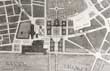
(Code No. 6929)
Cressinet, M.
(Antique Print).
Date. July 11th, 1857.
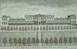
Prize Design for the New Government Offices - No.1. Block Plan for the War Office and Foreign Office. by M. Cressinet: Premium £500.
London. George, C, Leighton. Folio, [16 x 11ins].1857. Original antique print taken from the The Illustrated London News on ........£35.00 |
Click on picture above to view more images
How to order |
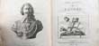
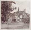
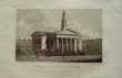
(Code No. 6920)Crocker, Charles.A Visit to Chichester Cathedral.Date 1849, 2nd edition..Chichester, William Hayley Mason. 12mo [4 x 6 3/4ins] Pp. 54. Original printed covers, marked and faded.A humble Chichester shoe-maker, who left school at 11, went on to become a poet of some renown, as well as becoming sexton and verger of Chichester Cathedral. At the age of seven he was fortunate enough to win a place at the city's Grey Coat Charity School. Crocker did not leave his beloved Chichester for the bright lights of London, but actually rooted himself more deeply in the city and its history. He became both sexton and verger of Chichester Cathedral. In 1848 he published 'Visit to Chichester Cathedral', the first ever guide book to the cathedral. As he grew older, Crocker delighted in taking visitors around the cathedral and telling them of its history and showing them the shrines and ornaments of that ancient place of worship.
|
SOLD.
|
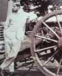
(Code No. 6846)
Anon.
(Antique Photograph, laid on to card).
Major Bredin - Woolwich..
Date. (c.1860).
Britain. Image size [8 1/2 x 7ins]. Original albumen photograph of Major Bredin leaning against an Armstrong Breech Loading 12 pounder 8 cwt, later known as RBL Major Bredin served in the Eastern Campaign of 1854-55, including the battle of Inkerman and siege of Sebastopol.... £150.00 |
Click on picture above to view more images
How to order |
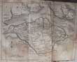
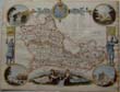
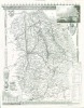
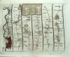
(Code No. 6839)Saxton, Christopher & P. Lea.(Antique map).HAMPSHIRE..Date. [c.1694]. London. Sold by Philip Lea at the Atlas and Hercules. Image size (15 1/2 x 17 1/4 inches). Original copper plate county map of Hampshire. Beautifully hand-coloured, slight marks to base line.Roads have been added according to Ogilby's survey, this therefore constitutes the first maps of the counties (except for the tiny playing-card map of 1676) to show roads, also on the map, the symbols for the respective towns have been augmented by the addition of crosses, to indicate the holding of markets: the hundreds are shown and a few' extra place names have been added. Bought from P.J. Radford & with his frame, not seen outside the frame. not laid down.......
|
SOLD
|
(Code No. 6830).
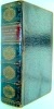
MALCOLM, James Peller [1767-1815].
Anecdotes of the Manners and Customs of London during the Eighteenth century, including the charities, depravities, dresses, and amusements, of the citizens of London, during that period .
Date. 1808.
London, Longman, Hurst, Rees. 4to, [9 x 11ins]. Pp. iv, 490, (8, index) + 12 Hand coloured fashion engraved plates, very good + 39 engraved plates of London views, marginal foxing. Contemporary full calf gilt, hinges, cracked and some surface loss.
MALCOLM, James Peller, artist, born in Philadelphia, He began painting and engraving in 1787, and afterward went to England, where he studied at the Royal academy three years, subsequently devoting himself to engraving , he worked for the "Gentleman's Magazine," and also drew and engraved plates for historical and antiquarian works. ......... . £170.00
|
Click on picture above to view more images
How to order |
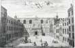
(Code No. 6805)
Stow, J. & Strype, J.
THE PROSPECT OF GUILD HALL.
Date. [c.1720],
London, Published by John Strype. Page size [14 1/2 x 10ins]. Original copper engraving printed for A. Churchill, J. Knapton, R. Knaplock, J. etc. Taken from "A survey of the cities of London and Westminster".(c.1720). .Slight creasing...... £55.00 |
Click on picture above to view more images
How to order |
(Code No. 6799)
Pennant, Thomas.
Some Account of London.
Date. 1791, 3rd edition.
London: Printed for Robert Faulder. 4to [10 x 8ins] .. Pp. 502 + [9 index] including engraved frontis + engraved title + 13 copper engraved plates, lacks map. Pages and covers loose.
Sold as a collection of plates only.... £35.00 |
Click on picture above to view more images
How to order |
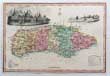
(Code No 6792)
Anon.
(Antique Map)..
Map of SUSSEX.
Date (c.1820).
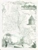
London. Page size [10 1/4 x 7ins]. Image size [10 x 6 3/4ins]. Original hand - coloured steel engraved map of Sussex with 2 inset vignettes of "Scene on the beach Brighton near the Steyen" and "Pavilion at Brighton" very good condition. Rare map...... £70.00
|
Click on picture above to view more images
How to order |
(Code No. 6695)
Arnold, Frederick.. Rev.
Oxford and Cambridge their colleges memories and associations.
Date. [c.1870].
London, The Religious Tract Society. 4to, [7 1/4 x 9 1/4ins]. Pp. viii, 400. Illustrated throughout engraved by Mr. Edward Whymper. some foxing. Original gilt decorated cloth, marked and slight chipping to top bottom of spine. All edges gilt. Bevelled boards. Owner's dedication on front free end paper..... £40.00 |
Click on picture above to view more images
How to order |
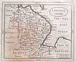
(Code No. 6673)
GROSE, Francis / Seller. J.
Map of LINCOLNSHIRE.
(Antique Map).
Date. 1798.
London, Sold by H. H Symonds. Page size [7 x 10ins]. Original copper engraved map, The map is a reprint of John Seller's map Camden's Britannia abridged, J. Wild...
Francis Grose had shown a keen interest in drawing, having attempted sketches of medieval buildings as far back as 1749, and having taken formal instruction at a drawing school 1750s. He was not a particularly gifted draughtsman but he mixed in the London artistic group and began to exhibit, first at the Society of Artists in 1767-8 and then at the Royal Academy. His interest was in the field of medieval remains..... £25.00 |
Click on picture above to view more images
How to order |
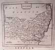
(Code No. 6669)
GROSE, Francis / Seller. J.
Map of SUFFOLK.
(Antique Map).
Date. 1798.
London, Sold by H. H Symonds. Page size [7 x 10ins]. Original copper engraved map, The map is a reprint of John Seller's map Camden's Britannia abridged, J. Wild...
Francis Grose had shown a keen interest in drawing, having attempted sketches of medieval buildings as far back as 1749, and having taken formal instruction at a drawing school 1750s. He was not a particularly gifted draughtsman but he mixed in the London artistic group and began to exhibit, first at the Society of Artists in 1767-8 and then at the Royal Academy. His interest was in the field of medieval remains....... £25.00 |
Click on picture above to view more images
How to order |
(Code No. 6628)
GROSE, Francis / Seller. J.
Map of Berkshire.
(Antique Map).
Date. 1798.
London, Sold by H. H Symonds. Page size [7 x 10ins]. Original copper engraved map, The map is a reprint of John Seller's map Camden's Britannia abridged, J. Wild...
Francis Grose had shown a keen interest in drawing, having attempted sketches of medieval buildings as far back as 1749, and having taken formal instruction at a drawing school 1750s. He was not a particularly gifted draughtsman but he mixed in the London artistic group and began to exhibit, first at the Society of Artists in 1767-8 and then at the Royal Academy. His interest was in the field of medieval remains...... £25.00 |
Click on picture above to view more images
How to order |
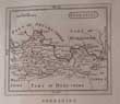
(Code. No 6625)
GROSE, Francis / Seller. J.
Map of Essex.
(Antique Map).
Date. 1798.
London, Sold by H. H Symonds. Page size [7 x 10ins]. Original copper engraved map, The map is a reprint of John Seller's map Camden's Britannia abridged, J. Wild...
Francis Grose had shown a keen interest in drawing, having attempted sketches of medieval buildings as far back as 1749, and having taken formal instruction at a drawing school 1750s. He was not a particularly gifted draughtsman but he mixed in the London artistic group and began to exhibit, first at the Society of Artists in 1767-8 and then at the Royal Academy. His interest was in the field of medieval remains...... £25.00 |
Click on picture above to view more images
How to order |
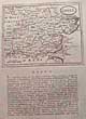
(Code No. 6623)
GROSE, Francis / Seller. J.
Map of Middlesex.
(Antique Map).
Date. 1798.
London, Sold by H. H Symonds. Page size [7 x 10ins]. Original copper engraved map, slightly slanted in relation to the text. The map is a reprint of John Seller's map Camden's Britannia abridged, J. Wild...
Francis Grose had shown a keen interest in drawing, having attempted sketches of medieval buildings as far back as 1749, and having taken formal instruction at a drawing school 1750s. He was not a particularly gifted draughtsman but he mixed in the London artistic group and began to exhibit, first at the Society of Artists in 1767-8 and then at the Royal Academy. His interest was in the field of medieval remains........ £25.00 |
Click on picture above to view more images
How to order |
(Code No. 6608)
Taylor, Ann 1782-1866.
City scenes: or, A peep into London, for good children / By The author of Rural scenes..
Date. 1809..
London : Printed for and sold by Darton and Harvey, 12mo. [4 x 6 1/4ins]. Pp. 72 + 105 copper engraved views on 35 leaves, 4 pages crudely coloured & a few marginal nicks. Illustrated by Isaac Taylor. Written by Ann and Jane Taylor.
Showing the various London trades:- the show man, knife-grinder, ballad singer, press gang, orange boy, paving the streets, coach maker, eating house, etc. Original quarter morocco gilt over trade boards, some surface loss.... £220.00 |
Click on picture above to view more images
How to order |
(Code No. 6574)
Cox, Thomas.
A Topographical, Ecclesiastical, and Natural History of SUSSEX.
Date. 1724 to 1731.
London, T. Cox. Savoy. 8vo. [7 1/4 x 9 ins]. Pp.463 to 580, water staining to edges + Copper engraved map of Sussex by Grose/Seller. The Morden map has been replaced with the Seller/Grose map of [.c1790]. Modern boards, Holding firm.
The work, usually attributed to Thomas Cox, was first published in monthly numbers and was afterwards collected into 6 vols., of which the 1st and 2nd came out in 1720 and the remaining 4 vols. from 1724 to 1731. The first two were published for M. Nutt and J. Morphew, but the succeeding ones were for T. Cox......... £45.00 |
Click on picture above to view more images
How to order |
(Code No. 6567)
Collingwood, S.
At Maldon, Essex. UK.
(Antique print).
Date. [c.1850].
London, Joseph Boulton & Co. Size of page [11 x 15ins]. Original antique lithographic print by C. Collingwood....
In Maldon's parish church of All Saints is a memorial window to George Washington, whose great-great grandfather, Lawrence Washington, is buried here. Unveiled by an American diplomat on 5 July 1928, the window displays Saint Nicholas with the Mayflower, Saint George and Saint Joan of Arc in the centre. At the top are the arms of the Washington family, and the arms of the USA, England, Scotland and Wales. At the bottom are depictions of George Washington, the landing of the Mayflower, the signing of the Declaration of Independence, and the Statue of Liberty...... £50.00 |
Click on picture above to view more images
How to order |
(Code No. 6549)
Black's picturesque guide to the Isle of Wight.
Date. 1880. 8th Edn.
Edinburgh : A. and C. Black. 8vo, Pp. x, 85 + 112 adverts, page 73-74 damaged + 2 Maps, one map split at folds, no loss + 2 engraved plates. Gilt decorated cloth, very good....... £30.00 |
Click on picture above to view more images
How to order |
(Code No. 6473)
Cruchley.
New map of Essex, Railways & Names of Stations, also the Villages, Turnpike Roads, Gentlemen's Seats etc. Improved from the Ordnance.
Surveys.
Date. [c.1850].
London, Gall and Inglis. Page size [22 1/2 x 20ins]. folding to [4 1/2 x 7ins] in printed boards, split to folds, repaired with no loss..18 Sectional coloured map. Scale ( approx), 1 inch to 2 1/2 miles.Splits with slight loss. Sold as a working copy only........ £35.00 |
Click on picture above to view more images
How to order |
(Code No. 6434)
Pennant, Thomas, 1726-1798.
Journey from Chester to London.
Date. 1811.
London. Wilkie and Robinson... 4to, 6 1/4 x 9 3/4ins. Pp viii, 622 + 6 copper engraved plates, slight foxing & off setting on to text. Full calf gilt. Raised spine bands, slight rubbing. Marbled edges.
Thomas Pennant's son David edited this work. Thomas Pennant was a prolific writer specialising in travel and natural history, one of his most popular works on travel was his tour to Scotland in 1769. The correspondence he received from Gilbert White was the basis for White's book "The Natural History and Antiquities of Selborne". Unfortunately Pennant's letters to White have been lost.....£110.00 |
Click on picture above to view more images
How to order |
(Code No. 6397)
Pettitt.
Album of Views of London & Chester.
Date. [c.1890].
London, Pettitt. Oblong folio, [15 x 10 1/4ins]. 30 Photographic type views of London + 30 Photographic type views of Chester, UK + 2 others, including a panorama of the Thames, (Houses of Parliament to the Royal Hotel). Street scenes, public buildings, etc. Original half morocco gilt, rubbed & chipping to top and bottom of spine...... £65.00 |
Click on picture above to view more images
How to order |
(Code No. 6370)
Wolridge & others..
( 3 Antique London Prints).
Bruce Castle, Tottenham, Middlesex, Old Manor-House, Hackney and Rectorial House, Newington Butts.
Dates. [c.1790-1800].
London : N. Smith & Manson, Page sizes [ 16 x 11ins]. Image sizes [7 x 8 1/4ins]. 3 Original copper engraved prints....... £60.00 |
Click on picture above to view more images
How to order |
(Code No. 6369)
COLE, B..
( 3 Antique London Prints).
The East Front of the Horse and Foot Guards at Whitehall, The East Prospect of Haberdashers Alms Houses at Hoxton. and... Bethlehem Hospital.
Date. [c.1770].
London : R. Baldwin, Page sizes [ 17 1/2 x 11ins]. Image sizes [12 1/2 x 8ins]. 3 Original copper engraved print by Benjamin Cole. (The print Haberdashers Alms Houses at Hoxton, badly creased and split into engraved area)..... £70.00.
|
Click on picture above to view more images
How to order |
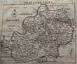
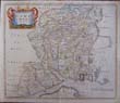
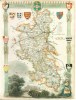
(Code No. 6365)SPEED, John.(Antique Map).LINCOLNSHIRE, The countie and citie of Lyncolne described with the armes of them that have been Earles thereof since the conquest.Date. 1676.London, Bassett & Chiswell. Page size [24 x 20ins]. Image size [20 x 15 ins].... Original copper engraved coloured map, with two columns of arms + a plan of the city of Lincoln. Slight edge nick not affecting engraved image.With plain back
.The following entry appeared in the Term Catalogue of 10 Feb. 1676."At the Shops of the said Thomas Basset and Richard Chiswell, the
Particular Maps of . . . any Shire and County in the Kingdoms of Great Britain and Ireland, will be Sold by themselves, without theDescription, to such as desire them, each Map, 6d."
|
SOLD.
|
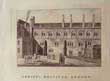
(Code No. 6345)
Rooker, Michael. Angelo & Edward Rooker.
Queen's College, Oxford.
Date. 1775.
London. Page size, [22 3/4 x 16 1/2ins]. Image size, [17 1/2 x 12ins]. Original proof before letters, (trial impressions taken of the prints before the added lettering), copper engraving by Michael. Angelo Rooker, printer's crease. nick to outer edge not affecting image. From the Oxford Almanack series..... £150.00 |
Click on picture above to view more images
How to order |
(Code No. 6323)
Read, Thomas.
Map of ISLE of WIGHT + Text.
Date. 1743-46.
London. Page size, [8 1/4 x 7ins]. Pp.179 - 186 + Original copper engraved folding map of the Isle of Wight by Thomas Read, damaged.
The county maps with a topographical description were published alphabetically in weekly parts, 1743-46 by Thomas Read. Only 29 county maps in three volumes have been located up to the county of Shropshire. The fourth volume does not appear to have been traced. Volume four must have at some time been published because John Rocque was able to acquire the complete set of 52 plates in about 1750, updating some the maps with an altered scale bar. The Read maps + text are very rare, the John Rocque reprint less so..... £45.00 |
Click on picture above to view more images
How to order |
(Code No. 6321)
Read, Thomas.
Map of HERTFORDSHIRE + Text.
Dates. 1743-46.
London. Page size, [8 3/4 x 6 3/4ins]. Pp. 251-338 + Original Copper engraved folding map of Hertfordshire by Thomas Read.
The county maps with a topographical description were published alphabetically in weekly parts, 1743-46 by Thomas Read. Only 29 county maps in three volumes have been located up to the county of Shropshire. The fourth volume does not appear to have been traced. Volume four must have at some time been published because John Rocque was able to acquire the complete set of 52 plates in about 1750, updating some the maps with an altered scale bar. The Read maps + text are very rare, the John Rocque reprint less so..... £100.00 |
Click on picture above to view more images
How to order |
(Code No. 6309)
Grose. Francis,
7 ANTIQUE PRINTS of LONDON .
Date. [c.1784.]
London. S. Hooper. ( Approx), image sizes [6 X 4ins]. 7 Original copper engraved prints:- 2 x Ely House, London, Ely House, (plate 2), Plan of Ely House, London Christ' Hospital London, Christ' Hospital London (plate 2), Hampton Court, Middlesex, The prints are guaranteed to be over 150 years old....... £40.00 |
Click on picture above to view more images
How to order |
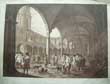
(Code No. 6295)
Chapman & Lutherburg.
(2 Large antique prints).
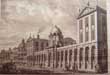
Royal Exchange, London...Interior and exterior views.
Date. [c.1780]. Not the modern restrikes.
London, Chapman. Page size, (approx), (25 x 17ins). Image sizes, (approx), [20 ½ x 15 3/4ins]. 2 Original proof before letters, (trial impressions taken of the prints before the added lettering), copper engravings, 2 splits into engraved areas, (approx, 1 ½" & 4") Laid on linen, nicks & creases to outer edges not affecting images. Engraved by Francesco Bartolozzi.
The Royal Exchange was officially opened on 23 January 1571 by Queen Elizabeth I who awarded the building its royal title and license to sell alcohol. During the 17th century, stockbrokers were not allowed in the Royal Exchange because of their rude manners; hence they had to operate from other establishments in the vicinity, such as Jonathan's Coffee-House. Gresham's original building was destroyed in the Great Fire of London in 1666. A second complex was built on the site, designed by Edward Jarman, and opened in 1669, but was also destroyed by fire on 10 January 1838. It had been used by the Lloyd's of London insurance market, which was forced to move temporarily to South Sea House following the 1838 fire...... £300.00 |
Click on picture above to view more images
How to order |
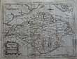
(Code No. 6280)SPEED, John.(Antique Map).OXFORDSHIRE described with ye Citie and the Armes of the Colledges of ye famous University. Aº 1605..Date. 1676.London, Bassett & Chiswell. Page size [21 3/4 x 16 1/4ins]. Image size [20 3/4 x 15 1/4ins]. ... Original copper engraved coloured map, with two columns of college arms, a plan of the city of Oxford and two scholars examining a globe.Taken from "The Theatre of the Empire of Great Britain". Because the map has been laid onto card the cost is lower than the usual price. Slight foxing. Guaranteed to be over 300 years old......
|
SOLD.
|
(Code No. 6142)SPEED, John.(Antique Map).ESSEX, divided into Hundreds.....Described by John Norden, augmented by J. Speede, and are to be solde by G. Humble. Cum Privilegio.Date. [c.1627]. London. G. Humble. Image size [20 x 15ins].Original engraved map of Essex by Jodocus Hondius, (modern colouring), inset plan of Colchester. English text. Trimmed to bottom left corner, nicks and loss to outer blank margins......
|
SOLD.
|
(Code No. 6070)
Kitchin, Thomas.
(Antique Map).
A New Map of the Isle of Wight. Drawn from Surveys by Tho' Kitchin Geog'.
Date. 1763.
London, London Magazine. Page size (10 1/2 x 8 1/4ins]. Original copper engraved folding map, slight browning.
Thomas Kitchin, (1719-1784) was an English engraver and cartographer. He was born in Southwark, and was apprenticed to Emanuel Bowen in 1732. Originally based in Clerkenwell, by late 1755 Kitchin was established on Holborn Hill. From 1773 Kitchin was appointed royal Hydrographer to the king....... £50.00 |
Click on picture above to view more images
How to order |
(Code No. 6059)BROWN. FRANK.Frost's Drawings of Ipswich and Sketches in Suffolk, With Memoir and Portrait of George Frost, and Short Descriptive Notes on the Principal Plates.Date. [c.1895]. Ipswich. Pub' by the Author. Folio, [14 x17 ins]. Half title + Printed colour frontis + Title page + Dedication + Subscribers + Plate list + Preface 2p + Text pp. 13-24 + 27 PLATES, (as listed), very good condition.This work is published in this form only, and limited to 105 copies each, this copy being no. 90, and signed by the author. Original silk decorated boards with a Coat of Arms, frayed. Cloth spine gilt......
|
SOLD.
|
(Code No. 6041)KEERE, Pieter van den.(Antique Map)Oxfordshire.Date. 1627.London. Humble. George. Map image size [5 x 3 1/4 ins]. Copper engraved miniature map of Oxfordshire by Van De. Keere, 2 worm holes into engraved area + 5 Pages of descriptive English text. Abridged from John Speed's The Theatre of the Empire of Great Britain. vg.
|
SOLD.
|
(Code No. 6035)
BOWEN, Emanuel & Kitchin Thomas.
(Large Antique Map).
An Accurate Map of SUSSEX........
Date. [c.1760].
London, R. Sayer. Carrington Bowles & John Bowles. Page size [30 x 23ins].Original outline hand-coloured copper engraved double page map, nicks to outer blank margins & 2 minute holes to map surface.
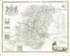
The largest of the county map to date and incorporating many new details, but also introducing some curious errors. The degrees of longitude (West of London) are about 2 degrees out and the main body of the counties are too wide from east to west. They show towns with their market days, villages (with indications to show whether rectory or vicarage), religious houses, charity schools, castles, hundreds, hills, parks, forests, sands, meres, rivers, brooks, post roads with measured distances between the towns, and several other roads now shown for the first time. Numerous descriptive notes are scattered around the map. A circular compass indicator. The title with the imprint below, scale, "Explanation" (of the symbols on the map), and the dedication. The titles have a pictorial surround; Thomas Kitchin was an engraver and publisher at The Star opposite Ely Gate, Holborn, and London from 1738 to 1776. He was a prolific producer of maps, plans and charts, and was by appointment Hydrographer to the King - George III. His output included sheet maps, series of maps for the Universal Magazine and the London Magazine, and atlases. He worked with Thomas Jefferys and particularly with Emanuel Bowen....... £250.00 |
Click on picture above to view more images
How to order |
(Code No. 6028)
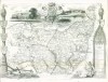
SMITH, William Henry, & Sons.
(Antique sectional map).
Reduced Map of London and Environs.
Date. [c.1890].
London, W. H. Smith. 8vo, [4 x 6ins]. Original 18 sectional engraved coloured linen backed map by J. Bartholomew. Page size [15 x 19 1/4ins]. Scale, 4 miles to an Inch. Extending from Luton on North to Tumbridge Wells on South, and from Aldershot West to Sheerness East. Original cloth covers with printed tital label, rubbed...... £45.00 |
Click on picture above to view more images
How to order |
(Code No. 6026)
BOWEN, Emanuel & Kitchin Thomas.
(Large Antique Map).
An Accurate Map of Berkshire........
Date. 1756.
London, Carrington Bowles & John Bowles. Page size [30 x 23ins]. Original outline hand-coloured copper engraved double page map, nicks to outer blank margins, very good.
The largest of the county map to date and incorporating many new details, but also introducing some curious errors. The degrees of longitude (West of London) are about 2 degrees out and the main body of the counties are too wide from east to west. They show towns with their market days, villages (with indications to show whether rectory or vicarage), religious houses, charity schools, castles, hundreds, hills, parks, forests, sands, meres, rivers, brooks, post roads with measured distances between the towns, and several other roads now shown for the first time. Numerous descriptive notes are scattered around the map. A circular compass indicator. The title with the imprint below, scale, "Explanation" (of the symbols on the map), and the dedication. The titles have a pictorial surround; Thomas Kitchin was an engraver and publisher at The Star opposite Ely Gate, Holborn, and London from 1738 to 1776. He was a prolific producer of maps, plans and charts, and was by appointment Hydrographer to the King - George III. His output included sheet maps, series of maps for the Universal Magazine and the London Magazine, and atlases. He worked with Thomas Jefferys and particularly with Emanuel Bowen. Very rare edition......... £250.00 |
Click on picture above to view more images
How to order |
(Code No. 6022)
Grose. Francis,
(3 ANTIQUE PRINTS ).
KENT.
Date. [c.1784.]
UK. London. S. Hooper. ( Approx), image sizes [6 X 4ins]. 3 Original copper engraved prints:- 2 of Dover Castle and one of Lyme Castle. The prints are guaranteed to be over 150 years old. ..... £30.00 |
Click on picture above to view more images
How to order |
(Code No. 6023)
Robert Morden (c.1650-1703).
(Antique Map).
Oxfordshire.
Date. 1722, 2nd edn.
London, Swale, Awnsham and Churchill. Page size [14 1/2 x 18ins].Copper engraved County map of OXFORDSHIRE by Robert Morden, closed splits to centre fold & closed nicks to outer edges.
The map is based on John Speed's map. Scale, six English miles [ =1 1/2 in.]. Shell-type cartouche containing the title and Morden's name. The map has graduated borders. Taken from Camden's Britannia of 1695. was a British bookseller, publisher, and maker of maps and globes. He was among the first successful commercial map makers. Sold as a working copy only.......£75.00
|
Click on picture above to view more images
How to order |
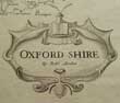
(Code No. 6021)Jansson, Jan.(Antique Map of OXFORDSHIRE).Oxonium Comitatus vulgo Oxford Shire.Date. [c.1650].[Amsterdam]. Page size [22 x 19ins]. Original copper engraved map with cartouche and arms of the colleges. Engraved view of a stone circle, (Avebury?), on the reverse, damage to top fold and splits into engraved area.......
|
SOLD.
|
(Code No. 6016)
Mogridge, George
("Old Humphrey") (1787-1854).
Old Humphrey's Walks in London and Its Neighbourhood.
Date. [c.1840].
London. Religious Tract Society. 8vo, [6 x 4 ins]. Pp viii, 352, vg. Original embossed cloth gilt, spine faded with slight splits to hinges.
George Mogridge was a prolific 19th century writer, poet and author of children's books. He is chiefly known by his pseudonym of 'Old Humphrey', under which name he published 46 works, He wrote approximately 200 published works, many of which are still in publication today, and at the time of his death it was estimated that over 15 million copies of his writings were in circulation........ £35.00 |
Click on picture above to view more images
How to order |
(Code No. 6002)
Ogilby. John.
( Antique Strip Road Map).
The Road from LONDON to CARLISLE, Number 37.
Showing section - Darleston, Newcastle under Line, Brewerton, Gridham, Warington, Newton, Wigan, Whittle ending at Preston.
Date. 1675 - 98.
London. Page size, (approx), [ 18 1/4 x 15 ins ]. Image Size [ 16 x 13 ins ]. Original copper engraved Strip Road Map, (modern colouring), slight creasing and 2 marginal nick just outside engraved area . Each map strip shows towns, villages, mansions with owner's name, castles, wind mills, beacons, gallows, woods, rivers, and hills etc. Elaborate title cartouche and compass roses to each map strip.
John Ogilby was a topographer, printer, and map-maker, born in Edinburgh, EC Scotland, UK. A dancing teacher and theatre owner, he lost everything in the Civil War, but after the Restoration obtained court recognition and became a London publisher. The great fire of 1666 destroyed his stock but got him the job of surveying the gutted sites in the city. He established a thriving printing house and was appointed 'king's cosmographer and geographic printer'. His most important publications were engravings of maps and atlases, including Africa (1670), America (1671), and Asia (1673), and a road atlas "Britannia" (1675), unfinished at his death. He was also the first cartographer to adopt the statute mile. Scale 1inch to the mile, each mile is divided into furlongs indicated by dots in the centre of the road. Guaranteed to be over 300 years old....... £130.00 |
Click on picture above to view more images
How to order |
(Code No. 5967)WALKER, J. AND C.(Antique Sectional Map).Hampshire and Isle of Wight.Date. [c.1840]London. Longman Hurst, Rees and Orme. Sold by J. Wyld, Geographer to Her Majesty (2 trade labels). .. Engraved hand coloured 15 sectional linen backed map, (16 by 13.25 inches). folding to 5 x 4 inches, vg. Showing Compass rose and scale bar. References for places of Election and Hundreds etc. Original cloth with printed title label on front cover......
|
SOLD
|
(Code No. 5882)
LYSONS, Daniel & Samuel.
BUCKINGHAMSHIRE.
Magna Britannia; Being a Concise Topographical Account of the Several Counties of Great Britain.
Vol. I. Part III.
Date. 1813.
London, T. Cadell & W. Davies. 4to, [9 1/2 x 12ins]. Pp. 449 to 728, [1], some browning to the text + 12 Copper engraved prints + Double page map of Buckinghamshire. Modern morocco gilt, retaining the original boards.
Daniel Lysons (1762-1834) was a notable English antiquary and topographer of the late 18th and early 19th century. With his brother Samuel, Lysons began Magna Brittania, being a concise Topographical Account of the several Counties of Great Britain (1800-1822), the intention was to research and publish the history of every county in England, unfortunately only about 11 counties were completed. (Bedfordshire, Berkshire, Buckinghamshire, Cambridgeshire, Cheshire, Cornwall, Cumberland, Derbyshire, Devonshire, London & Middlesex)...... £95.00
|
Click on picture above to view more images
How to order |
(Code No. 5839)Tallis, John.[Antique Map.]CHANNEL ISLANDS.Date. [c.1850].London. J & F Tallis. Page size, [15 x 10 1/2ins]. Original steel engraved map with original outline hand colouring. 4 vignette views. Decorated border, Centre fold, vg.John Tallis' maps are the last decorative, regional maps to be published.......
|
SOLD.
|
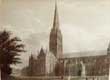
(Code No. 5832)
Dodsworth, William.
An Historical Account of The Episcopal See and Cathedral Church of Sarum, or Salisbury;
Comprising Biographical Notices of the Bishops; the History of the Establishment, from the Earliest Period; and a Description of the Monuments.
Date. 1814.
Salisbury, Brodie and Dowding. 4to, [9 1/2 x 12ins]. Pp. xx, some foxing, 240 + Engraved title + 19 Steel engraved plates, (as listed), slight foxing & marks. Original half calf, hinge leather split and rubbed. Holding firm.
Salisbury Cathedral is an Anglican cathedral in Salisbury, England, and is considered one of the leading examples of Early English architecture. The main body was completed in only 38 years, from 1220 to 1258. The cathedral has the tallest church spire in the United Kingdom (404 ft). The cathedral also has the largest cloister and the largest cathedral close in Britain (80 acres). The Cathedral contains the world's oldest working clock (from AD 1386) and has the best surviving of the four original copies of Magna Carta ....... £80.00 |
Click on picture above to view more images
How to order |
(Code No. 5772)
Cooke, G. A.
Topographical and Statistical Description of the County of Oxford, Gloucester and Monmouth.
3 Volumes bound up into 1.
Date. [c.1802].
London, C. Cooke. 12mo, [4 x 6ins]. .. Pp. 142,168, 144 + 3 FOLDING COUNTY MAPS by J. CARY, some browning. Original half calf gilt with marbled boards, rubbed with some paper loss, Tight copy....... £90.00 |
Click on picture above to view more images
How to order |
(Code No. 5659)
Tallis, John.
Volume 1 of 2.
Tallis's Illustrated London, in Commemoration of The Great Exhibition of all Nations in 1851, Forming a Complete Guide to the British Metropolis and its Environs..
Date. [c.1850].
London, John Tallis and Company. 8vo, [5 1/4 x 7 1/2ins]. Ex Library. Pp. 320, slight foxing, Description by William Gaspey, 2 library stamps only on additional title + 108 Steel engraved prints on 74 pages, one folding. Original half calf gilt, rubbed...... £110.00 |
Click on picture above to view more images
How to order |
(Code No. 5578)Bartholomew, J.(Antique Map).CITIES, PORTS & HARBOURS. (LONDON) 1st Metropolitan District. .Page. No 26.Date. [c.1860].London, A. Fullarton & Co. Page size [18 1/2 x 12 1/2ins].Original hand-coloured steel engraved maps of Portland + Estuary of the Thames & the Medway and London + Metropolitan Burghs and Southern & Eastern Environs. 3 Town plans on a single page. very good condition...
|
SOLD.
|
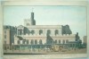
(Code No. 5522)
Carter. Owen. B.
(Antique Print).
The Hospital of St. Cross. Winchester, Hampshire.
Date. 1848.
UK. Salisbury, Brown & Co & Day & Son, lithographer to the Queen. Page size [22 1/2 x 17 1/2ins.] image size [20 x 14ins.] Original hand-coloured lithograph by George Hawkins, very slight browning.
The almshouses and vast Norman chapel of Hospital of St Cross were founded just outside the city centre by Henry de Blois in the 1130s. Since at least the 14th century, and still available today, a 'wayfarer's dole' of ale and bread has been handed out there. It was supposedly instigated to aid pilgrims on their route through to Canterbury. Rare print....£150.00 |
Click on picture above to view more images
How to order |
(Code No. 5495)
Moule, Thomas.
BERKSHIRE.
(Antique Map, Guaranteed over 140 yrs old ).
Date 1836 -52.
London. Virtue. Approx size [10 1/2 x 8ins]. Steel engraved hand-coloured, (modern colouring), county map of BERKSHIRE, nick to outer edge not affecting engraved area. Decorated with five vignettes which includes view of Windsor and Virginia Water. Ornamental border with symbolic figures woven into the design, heraldic coat of arms.
Moule's county maps are the last series of decorative maps to be published. Slight foxing....£50.00 |
Click on picture above to view more images
How to order |
(Code No. 5441)Ellis, J.The London Guide and Pocket Plan of the City of London and Westminster....with the New Buildings to the Year 1775. By J Ellis.Date. 1775.London Carington Bowles. Page size 20 1/4 x 15 1/4ins. Linen backed map, (outline colour), in 16 sections, linen sections frayed and slightly marked. Holding firm. "A Table of References to the Churches and Principal Buildings, Shewing their situation in the above Plan".Map limits: - Chelsea Water Works, Hanover St, Marylebone, and Bethnal Green...
|
SOLD.
|
(Code No. 5440)Faden, W.A Plan of London and Westminster with the Boroughs of Southwark. 1821.Date. 1st-Jan-1821. London, W. Faden. Page size [18 1/2 x 36 1/4ins]. Image size [17 1/2 x 35 ins]. Linen backed map, (outline colour), in 24 sections. Listing "51 Parishes without the Limits of the City of London". Colour coded explanation :- Intended Streets and Buildings not finished, (yellow) - The Liberties of Westminister, (Green) - Limits of the City, (Red) - Rules of the Bench and Fleet, (orange). Scale, (approx), 6 1/2ins to the Mile. very good condition.Map limits: - Rotherhithe Bason, Bethnal Green, Sloane Street and Regents Park. Folding into a marbled slip case size, (5 x 7ins), with a printed title label, edges slightly rubbed....
|
SOLD.
|
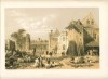
(Code No. 5438)Buck, Samuel and Nathaniel.( Antique Print.)The East Prospect of the City of Winchester. Hampshire.Date. 1736.London, Samuel and Nathaniel Buck. Page size. [33 x 13 1/2ins]. Image size [31 x 10ins]. (approx). Original copper engraved panoramic view, (later colour), drawn and engraved by one of the most important topographical artists of the 18th century.The brothers, Samuel and Nathaniel Buck, they made a series of etched panoramas and views of British towns, castles and abbeys etc, plus a history of the town, and a reference key below the view.Winchester is a historic cathedral city and ancient capital of Wessex and the Kingdom of England. It is the county town of Hampshire, in South East England. The city lies at the heart of the wider City of Winchester, Winchester developed from the Roman town of Venta Belgarum....
|
SOLD.
|
(Code No. 5427)Cary, John.(Antique Map).Oxfordshire.Date. July 1st, 1809.London, J. Cary. Page size, [11 3/4 x 10ins]. Image size [10 1/4 x 8 1/2ins]. Original hand-coloured engraved map, very good. Taken from "CARY’S NEW AND CORRECT ENGLISH ATLAS".Cary introduced a new high standard of draughtmanship and engraving which, coupled with improved cartographical material (due to the numerous recent large-scale surveys of the counties) being available, made this atlas a great advance on any previous work of its kind. The firm of Cary re-issued this atlas in 1793, 1804, 1809, 1812, 1818, 1821, 1823, 1825, 1826, 1827 and 1831. Their successor, G. F. Cruchley, published further editions, brought up to date as regards parliamentary representation and by the addition of railways, in 1863, 1868, 1872 and 1875..
|
SOLD.
|
(Code No. 5423)
MORDEN, Robert.
(Antique Map).
HAMPSHIRE.
Date. 1695.
London: Abel Swale & John Churchill. Page size 18 x 15 1/4ins. image size 16 3/4 x 14 1/4ins. Original copper engraved map with later colouring, very good.
Robert Morden (c.1650-1703) was a British bookseller, publisher, and maker of maps and globes. He was among the first successful commercial map makers. Between about 1675 and his death in 1703, he was based under the sign of the Atlas at premises in Cornhill and New Cheapside, London. His cartographical output was large and varied. His best known maps are those of English counties first published in a new edition of Camden's "Britannia" in 1695, and subsequently reissued in 1722, 1753 and 1772. These maps were based on new information from gentlemen of each county, and were newly engraved. Each had a decorated cartouche, and showed numerous place names . Morden also produced in 1701 a series of smaller county maps often known as Miniature Mordens...£180.00 |
Click on picture above to view more images
How to order |
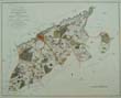
(Code No. 5418)
Anon.
(Antique Map).
A Map of the Hundreds of Downhamford, and of Bridge and Petham; with the City and County of the City of Canterbury, and the Liberty of Fordwich, which are marked thus........
Date. [c.1800].
England. Page size 19 1/2 x 16ins. Image size 18 1/4 x 14 3/4ins. Original hand-coloured copper engraved map, slight marks and mounted and laid down, (poor mount, will have to be replaced). Showing :- Canterbury, Petham, Littleborn, Fordwich, etc.... £60.00 |
Click on picture above to view more images
How to order |
(Code No. 5372)
Lysons, Daniel.
3 Volumes in 2. (Complete).
The Environs of London: Being an Historical Account of The Towns, Villages, and Hamlets, Within Twelve Miles of that Capital + An Historical Account of Those Parishes in the County of Middlesex.
Date. 1800-11, 2nd edn.
London, for T. Cadell and W. Davies. 4to, [11 x 9 1/2ins]. Pp. 316, [1]. 921, 853, foxing spots throughout + 65 Copper engraved plates, (as listed). Including vignette titles and one coloured plate. Plates listed:- Plan shewing the Ordnance Ground and parts adjacent at Woolwich, Plans and views of Hampton Court Palace, 3 maps of-Surrey- Middlesex-Kent, Plan of Hyde Park, etc. Original half calf gilt over decorated cloth, slight fading.
Daniel Lysons (1762-1834) was a notable English antiquary and topographer of the late 18th and early 19th century. With his brother Samuel, Lysons began Magna Brittania, being a concise Topographical Account of the several Counties of Great Britain (1806-1822), but after the first 11 volumes, (Bedfordshire, Berkshire, Buckinghamshire, Cambridgeshire, Cheshire, Cornwall, Cumberland, Derbyshire, Devonshire, London & Middlesex). Samuel died and the project was discontinued. Daniel Lysons also contributed views and illustrations to other works and published several pamphlets on religious and historical subjects. ... £500.00
|
Click on picture above to view more images
How to order |
(Code No. 5364)
Thomas Allen.
(28 loose steel engraved plates).
History of the Counties of Surrey and Sussex.
Date. 1829.
London, I. T. Hinton and Holdworth & Ball. Image sizes, (approx), [6 x 4ins.] 28 Loose steel engraved plates taken from Allen's History of the Counties of Surrey and Sussex. Engraved from the original drawings by Nathaniel Whittock. Dust marks and nicks to outer edges, not affecting the engraved areas. No text... £70.00 |
Click on picture above to view more images
How to order |
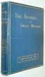
(Code No. 5349)
Anon.
The Rivers of Great Britain, Descriptive, Historical, Pictorial Rivers of the East Coast.
Date. 1897.
London, Cassell and Company Ltd. Small folio, [10 x 12 1/2ins.]Pp. viii, 376 + Illustratoins throughout. Original cloth gilt, slight marks & chipping to top of spine. All edges gilt... £45.00 |
Click on picture above to view more images
How to order |
(Code No. 5333)
Cooke, G. A.
Topographical and Statistical Description of the County of Hampshire, Sussex and Surrey.
Date. [c.1802]
London, C. Cooke. 12mo, [4 x 6ins].. Pp 167,179, 166,[2] + 3 FOLDING MAPS by J. CARY, some browning. Original half calf gilt with marbled boards, rubbed, Tight copy. £120.00 |
Click on picture above to view more images
How to order |
(Code No. 5331)Lilley John.River Thames Wharf Map.Date, [c.1920.]London, John Lilley & Son, Ltd. 8vo, [5 x 7ins]. 4 Linen backed coloured sectional maps on 2 leaves. Sizes 21 1/2 x 13 1/2ins folding to 5 x 7ins. Listing :- Port of London, The River Thames from London Bridge to Blackwall, The River Thames showing Wharves from Woolwich to Tilbury & Gravesend in 2 sections. From Montague-Smith's concise Railway Rate Book. Original cloth with printed title panel, slight marks.
|
SOLD.
|
(Code No. 5232)Britton, John.The Original Picture of London, Enlarged and Improved: Being a Correct Guide for the Stranger, as well as for the Inhabitant, to the Metropolis of the British Empire, Together with a Description of the Environs.Date. 1826.London, Longman, Rees.... 12mo, [4 x 6ins.] Pp xlii, 498, [2] adverts + 3 Folding maps, one map damaged with loss + Folding steel engraved frontis of Waterloo Bridge + 27 Full page steel engraved London views, (2 or more views per page). Original full calf gilt, rubbed.
|
SOLD.
|
(Code No. 5199)
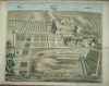
Kip, Johannes (c.1652-1722) & Leonard. Knyff, (1650-1721).
(Antique Print.)
Grimsthorpe Park/Castle in the County of Lincoln, UK.
Date. [c.1710.]
London: Joseph Smith. Image size, (approx), 19 x 14ins. (Plate No. 23.) Original copper engraved print taken from the original drawing by Leonard. Knyff, split to folds, repaired on the back.
An early engraving of Kip's topographical bird's-eye views of the castles, palaces and country houses of England. The complete work was first published in 1707 with 80 plates under the title Britannia illustrata; by 1716 three more volumes were added to it, and in 1728 a supplement was issued. The plates produced for this earlier work were engraved from "bird's-eye" drawings of Leonard Knyff (1650-1722), a fellow Dutchman who had come to London sometime after 1676. As the work expanded, plates were added by Kip and other eminent artists, forming a valuable record of the houses of the landed gentry. £120.00 |
Click on picture above to view more images
How to order |
(Code No. 5168)Walcott, MacKenzie Edward C. [Author]A Guide to the Coast of Sussex; Descriptive of scenery, Historical; Legendary; and Archaeological.Date. 1859.London.12mo, [165 x 105mm]. Pp viii,137, [16 adverts] + Folding engraved map. Original printed cloth, marked.
|
SOLD.
|
(Code No. 5106)
BUXTON, Edward.
North Epping Forest. With new Chapters on Forest Management, Geology of the District, Prehistoric Man and the Ancient Fauna, Entomology, Pond Life, and Fungi of the Forest.
Date. 1898, 5th edn.
London, E. Stanford. 8vo, [4 1/2 x 8 1/2ins.] Pp xii, [2],175, [1], very good + 6 Coloured maps including 4 folding, very good, Original printed cloth, slight fading. £30.00 |
Click on picture above to view more images
How to order |
| (Code No. 4984)Harrison, Frederic.Annals of an Old Manor-House. Sutton Place, Guilford.Date. 1893.London, MacMillan and Co. 4to, [9 1/2 x 11 1/2ins.] Pp. xvii, 231, including 59 Engraved and photographic single and double page plates + 9 Double page engraved pedigrees plates + 8 Coloured painted glass window plates, all with tissue guards, (as listed), very good condition. Edges untrimmed. Original decorated cloth gilt, slight marks and rubbed.
|
SOLD.
|
| (Code No. 4943)
Harding. J. D.
(Antique Print.)
Penshurst, Kent .
Date. [c.1850].
London . Page size [14 x 10 ins.] Original lithographic plates of Penshurst, Kent, taken from "The Baronial Halls, and ancient picturesque edifices of England". £35.00
gh and big enough to quarter half an army, was completed in 1341 for a rich London financier. A succession of royal dukes enlarged the house until in 1519 the 3rd Duke of Buckingham, made the mistake of entertaining Henry VIII in such sumptuous splendour, spending close to a million sterling, in today's money, that the monarch had his head off within two years. The estate then became royal property and Henry VIII stayed at Penshurst while courting Anne Boleyn at nearby Hever Castle. It was eventually given to the Sidney family.
|
Click on picture above to view more images
How to order |
| (Code No. 4935)Stanford's Coloured Chart of the Thames Estuary with the River from London Bridge to Gravesend.Date. [c.1920.] London, Edward Stanford Ltd. Size of large map [28 x 27 1/4ins]. Small map size [21 x 7ins.] Folding to [9 x 6ins.] Two folding linen-backed coloured maps of the River Thames to Gravesend and The Thames Estuary, Original cloth with printed title label.
|
SOLD.
|
| (Code No. 4864)
Moule, Thomas.
SUFFOLK.
(Antique Map, Guaranteed over 140 yrs old ).
Date. 1836 -52.
London. Virtue. Size [8 1/2 x 10 3/4ins.] Steel engraved coloured county map of SUFFOLK.strengthened fold on back of map. Decorated with vignette of
Euston Hall. Ornamental border with symbolic figure woven into the design, heraldic coat of arms. Moule's county maps are the last series of decorative maps to be published. £30.00
|
Click on picture above to view more images
How to order |
(Code No. 4863)Little, William.Illustrated London News.Date. July-Dec, 1844.London. The Proprietors of the I.L.N. Large Folio.[12 x 16ins.] 1844. Pp 420.+ Illustrations throughout including 2 wood engraved birds-eye folding panoramas of London, size of each panorama [48 x 16ins,] + illustrated key for each panorama. Showing South between New Church, Paddington and the Isle of Dogs, both very good condition. Original cloth gilt, marked.
|
SOLD.
|
| (Code No. 4850)
Moule, Thomas.
BUCKINGHAMSHIRE.
(Antique Map, Guaranteed over 140 yrs old ).
Date. 1836 -52.
London. Virtue. Size [8 1/2 x 10 3/4ins.] Steel engraved coloured county map of BUCKINGHAMSHIRE. (Modern colouring), decorated with vignette of Eaton College. Ornamental border with symbolic figure woven into the design, heraldic coat of arms. £35.00
Moule's county maps are the last series of decorative maps to be published.
|
Click on picture above to view more images
How to order |
| (Code No. 4818)Moule, Thomas.Middlesex. (Antique Map, Guaranteed over 140 yrs old ).Date. [1836 -52.] London. Virtue. Page size 10 3/4 x 8 1/2ins. Original steel engraved county map of Middlesex. marked to fold area and strengthened fold on back of map. decorated with vignettes, view of Buckingham Palace and Westminster Bridge. Ornamental border with symbolic figures woven into the design, heraldic coat of arms. Moule's county maps are the last series of decorative maps to be published.
|
SOLD.
|
| (Code No. 4799)
Moule, Thomas.
Lincolnshire.
(Antique Map, Guaranteed over 140 yrs old ).
Date. [1836 -52.]
London. Virtue. Page size 10 3/4 x 8 1/2ins. Original steel engraved county map of Lincolnshire strengthened fold on back of map. decorated with vignettes, Lincoln Cathedral and Grimsthorpe Castle. . Ornamental border with symbolic figures woven into the design, heraldic coat of arms. £30.00
Moule's county maps are the last series of decorative maps to be published.
|
Click on picture above to view more images
How to order |
| (Code No. 4798)Moule, Thomas.Kent.(Antique Map, Guaranteed over 140 yrs old ).Date. [1836 -52.] London. Virtue. Page size 10 3/4 x 8 1/2ins. Original steel engraved county map of Kent, strengthened fold on back of map. decorated with vignettes, Greenwich Hospital, Rochester and Dover. Ornamental border with symbolic figures woven into the design, heraldic coat of arms. Moule's county maps are the last series of decorative maps to be published.
|
SOLD.
|
| (Code No. 4797)
Moule, Thomas.
Oxfordshire (Antique Map, Guaranteed over 140 yrs old ).
Date. [1836 -52.]
London. Virtue. Page size 10 3/4 x 8 1/2ins. Original steel engraved county map of Oxfordshire, strengthened fold on back of map. decorated with vignettes, Oxford and Blenheim. Ornamental border with symbolic figures woven into the design, heraldic coat of arms. £30.00
Moule's county maps are the last series of decorative maps to be published.
|
Click on picture above to view more images
How to order |
| (Code No. 4794)
Moule, Thomas.
HAMPSHIRE.
(Antique Map, Guaranteed over 140 yrs old ).
Date. [1836 -52.]
London. Virtue. Page size 10 3/4 x 8 1/2ins.Original Steel engraved county map of HAMPSHIRE. slight nick to border, marked to fold area & strengthened on back of map. decorated with one vignette Southhampton. Ornamental border with heraldic coat of arms. £35.00
Moule's county maps are the last series of decorative maps to be published. Slight foxing. |
Click on picture above to view more images
How to order |
| (Code No. 4729)Marquand, Ernest David.Flora of Guernsey and the Lesser Channel Islands: Namely, Alderney, Sark, Herm, Jethou and the Adjacent Islets.Date. 1901.London, Dulau and Co. 8vo, [6 1/2 x 9ins.] Pp. viii, 501, Original cloth gilt. Page edges untrimmed. Guernsey is not part of the UK but rather a separate possession of the Crown, comparable to the Isle of Man. Guernsey is also not part of the European Union. The island of Guernsey is divided into 10 parishes. Together with the Bailiwick of Jersey, it is included in the collective grouping known as the Channel Islands.
|
SOLD.
|
| (Code No. 4711)
Mercator, Gerardus.
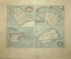
( Antique Map of Anglesey, Wight, Guernsey and Jersey.)
Anglesey - Wight Vectis Olim - Garnesay - Iarsay.
Date. [c.1600.]
Duisburg . Page size 21 1/2 x 18 1/2ins. Original hand coloured copper engraved map, Signed "Per Gerardum Mercatorem Cum Privilego" .(Latin Text). £250.00
Gerardus Mercator (5 March 1512 – 2 December 1594) was a Flemish cartographer. He was born in Rupelmonde in the County of Flanders, remembered for the Mercator projection world map that was named after him. In 1552, he moved to Duisburg, one of the major cities in the German Duchy of Cleves. He opened a cartographic workshop, where he completed a six-panel map of Europe in 1554. He also worked as a surveyor for the city. From Wikipedia, the free encyclopedia.
|
Click on picture above to view more images
How to order |
| (Code No. 4694)Stanford, E.(Antique Map of London.)THE PORT OF LONDON.Date. [c.1900].London. Edward Stanford Page size 30 1/2 x 20ins, folding to 7 x 5ins. Dissected, linen backed map with full original printed colour. Large map of the Dock areas of London between St. Katherine’s Dock and Tilbury Docks, very good condition. Ink title on spine.
|
SOLD
|
| (Code No. 4650)Knowles, C.C. and P.H. Pitt.The History of Building regulation in London : 1189-1972 : with an account of the District Surveyors’ Association.Date. 1972. London : Architectural Press, 4to. Pp.164 + Maps & illustrations. Original cloth gilt. Dust jacket, very good.
|
SOLD.
|
(Code no. 4643)Owen, J and E, Bowen.(2 Antique Strip Road Maps.)London, High Barnet, St. Albans, Dunstable, Stony Stratford, TowcesterandTowcester, Daventry, Dunchurch, Coventry, Coleshill, Lichfield.(Printed back to back on 2 single sheets,) Pages 51 & 52 & Pages 53 & 54.Date. 1720 or later edition.London. Tho, Bowles. Page size 5 1/2 x 7 1/2ins. 2 Original copper engraved strip maps, (modern hand-colouring). Taken from "Britannia Depicta" a more handy version of John Ogilby's Survey of 1675.
|
SOLD.
|
| (Code No. 4622)
SHEPHERD, Thomas.
Metropolitan Improvements or London in the Nineteenth Century being a series of Views...from ...Drawings by T. Shepherd. with Historical Topographical and critical Illustrations by James Elmes M.R.I.A. Architect...
Date. 1827-31.
London. Jones. 8vo, 6 x 8 1/2ins. Text pp. 3 - 316, (Lacking frontis & title), text pp. xlii (Brief view of London) + Folding plan, split at fold, no loss + 156 Steel engraved plates, marginal foxing throughout & nicks to the outer edges, 3 affecting the engraved area. Original full morocco gilt, slight rubbing to edges. Raised spine bands with gilt-tooled decorated panels. £160.00
|
Click on picture above to view more images
How to order |
| (Code No. 4613)
Senex, John.
(Antique strip map).
The Road from London to Andover & Denbigh to Holyhead, Anglesey, (printed back to back on a single sheet, Nos. 24 & 25). Actually Surveyed by a Wheel ...
Date. 1757.
London. John Bowles and Son, The Black Horse, Cornhill, London, Page size 9 x 7 1/4ins. Original copper engraved strip maps, road maps, hand coloured engraving, scale about 2-2.5 miles to 1in by J. Senex. First perform'd and publish'd by John Ogilby, Esqr; And now improved, very much corrected, and made portable by John Senex. £35.00
Senex's two volume road atlas was much smaller than Ogilby's "Britannia" and would fit into a traveller's pocket.
|
Click on picture above to view more images
How to order |
| (Code No. 4605)BACON'S NEW SHILLING MAP OF LONDON AND ILLUSTRATED GUIDE.No Date, [c.1880?].London. C.W. Bacon & Co. 8vo, 4 1/2 x 6 1/2ins. Pp 45, [1} + Double page Railway map [8 x 6ins] + Folding map of Central London, [16 x 6ins] + Large folding hand-coloured map of London, [33 x 24ins], slight splits to folds, no loss + Many text woodcut illustrations throughout. Original decorated boards, slightly rubbed.
|
SOLD.
|
(Code No.4577)
WEST, Robert.
( Antique Print of Church of St. Dunstan in the west, Fleet Street.)
The South East Prospect of the Church of St. Dunstan in the west.
Date. 1737.
London. Page size 15 x 9 3/4ins. Image size 8 x 14ins. Original copper hand-coloured engraving by B. Cole, taken from the original drawing by James Basire. £90.00
Samuel Pepys mentions the church in his diary but he only knew this old medieval building which was taken down in the early 19th century because it caused congestion to part of Fleet Street, also William Tyndale, who pioneered the translation of the Bible into English, was a lecturer there.
|
Click on picture above to view more images
How to order |
(Code No. 4558)Barfoot Peter, & John Wilkes.The Universal British Directory of Trade, Commerce, and Manufacture. (LONDON. WESTMINSTER and SOUTHWARK.)Volume one.Date. 1791.London: Printed for the Patentees, 8vo. Pp cxx,+ Text pp.1- 773 + pp. (3) Index. + Folding loose map of England Wales.The directory deals only with London, Westminster and Southwark and its environs, listing - names, trades and addresses of the inhabitants, from the Accountants to the Woollen drapers + coach and wagon inns, etc + Regulations and rates for hackney-coaches, etc. Original half calf, boards detached plus wear.
|
SOLD
|
(Code No. 4551)Anon.(Antique Aquatint Print.)EPPING. (Epping, Essex, in the United Kingdom).Date. 1st Jan, 1821.London. J. Mawman. Page size, 11 1/2 x 8 1/2ins. Image size 10 x 6ins. Original aquatint engraved print with contemporary hand colouring. The Frenchman Jean Baptiste Le Prince invented the aquatint process using a rosin ground around 1768.Famous painters, including Turner, Girtin and Cotman, began their careers as aquatint engravers and colourists.England depicted in these engravings probably looked more beautiful than it has ever done before or since.
|
SOLD.
|
(Code No. 4546)Anon.(History of Verulam and St. Albans: containing an historical account of the decline of Verulam and origin of St. Alban’s and of the present state of the town.)Date. [c1815?].St. Albans. S. C Shaw. (Minimal record).12mo, 4 x 6 1/2ins. Pp xi - xii, 239, [8?] Appendix. Lacks pp. i - x + 4 engravings, (never included in this book), foxing spots throughout. Original half calf over marbled boards, rubbed. Very rare,
|
SOLD.
|
(Code No. 4518)
Pennant, Thomas, 1726-1798.
Journey from Chester to London.
Date. 1811.
London. Wilkie and Robinson... 4to, 6 1/4 x 9 3/4ins. Pp viii, 622 + 6 copper engraved plates, slight foxing. Original full morocco gilt. Raised spine bands gilt with gilt-tooled decorated panels, slight rubbing. All edges gilt. All edges gilt. £110.00
Thomas Pennant's son David edited this work. Thomas Pennant was a prolific writer specialising in travel and natural history, one of his most popular works on travel was his tour to Scotland in 1769. The correspondence he received from Gilbert White was the basis for White's book "The Natural History and Antiquities of Selborne". Unfortunately Pennant's letters to White have been lost.
|
Click on picture above to view more images
How to order |
(Code No. 4481)Hinton. J.(Antique Print).A Perspective View of Queens University and All Souls Colleges in Oxford.Date. Ca 1770.London. Page size 13 x 8ins. Original folding copper engraved print by J. Hinton. Engraved for the Universal Magazine.
|
SOLD.
|
(Code No. 4475)
Burlington, Charles.
(Antique Print.)
View of Greenwich from Deptford.
Date. Ca1790.
London. J. Cooke & Harrison. Page size,14 x 9ins. Ca1790. Original copper engraved print, slight foxing to margins well away from engraved area. The print is guaranteed to be over 200 yrs old. £50.00
|
Click on picture above to view more images
How to order |
(Code No. 4473)Burlington, Charles.(Antique Print.)A View of Deptford.Date. Ca1790.London. J. Cooke & Harrison. Page size,14 x 9ins. Original copper engraved view, slight foxing to margins well away from engraved area. The print is guaranteed to be over 200 yrs old.
|
SOLD.
|
(Code No. 4431)IRELAND, W. H.Illustrated
by Geo. Shepherd,New and Complete History of the County of KENT.4
Volumes.Date. 1829.London: Virtue. Demy 8vo [8.6 x 6.6 ins]. Pp.
712, xix. 713 xv. 698, xviii. 780 xiii (8, errata), foxing throughout
and a few plates & text pages with nicks
and fraying to margins. (3pp missing). Engraved vignette title page + 128
STEEL ENGRAVED VIEW PLATES by H. Gastineau, and others + 2 Folding Maps, splits
to folds, (no loss). Contemporary half black calf gilt, rubbing.
Gilt-tooled spine panels, slight split to one hinge and rubbing.
|
SOLD |
(Code No. 4417)GAGE, John.The History and Antiquities of Hengrave, in Suffolk.Date. 1822.London. James Carpenter. 4to, [10 x 12 1/2ins.] Pp. vi, 263 + 29 (of 30) Copper engraved plates, lacking portrait of Sir Thomas Gage, (no plate cut out, publishing error). Original half calf gilt, rubbed & lacking part of spine. Hengrave Hall is a Tudor manor house near Bury St. Edmunds in Suffolk. Work on the house was begun in 1525 by Thomas Kytson the Elder, a merchant and member of the Mercers Company, who completed it in 1538. The house is one of the last examples of a house built around an enclosed courtyard with a great hall.
|
SOLD.
|
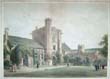
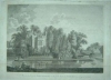
(Code No. 4415)
Harley. G.
Guildford Castle, Surrey.
( Antique Print).
Date. March 1822.
London. J, Dickenson. Page size 13.6 x 9.6ins. Image size 10 x 6ins. Attractive lithograph by G, Harley. Printed by Rowney & Forster. Guaranteed to be over 150 years old...... £30.00
|
Click on picture above to view more images
How to order |
| (Code No. 4382)Brayley, Edward.KENT.Volume 8.Date. 1808. London. Vernor and Hood, 8vo. Pp. 611 to 1366 (25) index, Engraved
title + 31 Copper engraved plates, some water staining + foxing.
Original half calf gilt, rubbed and split to hinges with some surface
loss. Binding still holding firm. Between the years 1801 and 1818 the authors undertook a topographical study of England and Wales, travelling many thousand of miles on foot, gathering information for their "Beauties of England and Wales",
publishing at regular intervals. Counties listed in alphabetical
order. |
SOLD
|
(Code No. 4380)
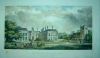
Greenwood. C. J.
View of Buckingham ( England ), with the Church.
No Date, ca1850.
Buckingham. E. Chandler bookseller. Image size 13 x 9 1/2ins. Page size 20 x 13 1/4ins. Original hand coloured lithographic print by R. Groom. marks to print surface. Printed by Moody, High Holborn. Taken from the original painting by C. J. Greenwood. £80.00 |
Click on picture above to view more images
How to order |
(Code No. 4264)Wright, M. T. SUTTON PLACE in Surrey.( Antique Print.)Date. March 31st 1804.London. I. Wright. Page size [15 x 10 ins.] Hand-coloured copper engraving print taken from the original drawing by M.T. Wright. Engraved by J. Basire, creasing to outer blank margin, not affecting the engraved area.Sutton Place in Surrey is a Grade I listed Tudor manor house built in 1530 for Sir Richard Weston. The estate has had a run of famous owners including Jean Paul Getty who spent the last 25 years of his life there.
|
SOLD.
|
(Code No. 4230)
(Antique Print.)
Farington, J.
MAIDSTONE.
Date, June 1st 1795.
London. J. Boydell. Shakespeare Gallert. Image size, [12½ x 8½ ins.] Original hand-coloured engraved aquatint by J C. Stradler. Mounted on to aboard. No.73. Taken from the book , John and Joseph Boydell’s " An History of the Principle Rivers of Great Britain" , slight foxing and marks to blank margins. £55.00
|
Click on picture above to view more images
How to order
|
(Code No. 4228)
Dower, John.
2 Antique Town Plans of London.
West ham & Greenwich.
Date ca1866.
London. Image size 22 x 14 ins, (approx). 2 Original engraved town plan of London. nicks to blank margins not affecting image. Scale, 9 1/4 ins to the Statute Mile. Map sheets sold "1s per sheet coloured". Area shown: - West ham & Greenwich. £160.00
|
Click on picture above to view more images
How to order |
(Code No. 4212)Buck, Samuel and Nathaniel.(Guaranteed Antique Prints.)The West View of Dover-Castle, in the County of Kent.Date 1735.Print size 18 x 11 ins. Image size 14 x 7 1/2 ins. Copper engraved print .The brothers, Samuel and Nathaniel Buck made a series of etched panoramas and views of British towns, castles and abbeys. This engraving describes the history of the castle from Norman times and the numerous changes of ownership below the image. Dedicated to To Lionel Duke & Earl of Dorset, etc, with his coat of arms. Slight marks and creasing to blank margins,
|
SOLD
|
(Code No. 4198)
Bacon's New Survey Map of Northampton, Huntingdon, Cambridge & Bedford.
Manchester. Bacon and Co. No date, ca 1910. 4to, 13 x 8 1/2 ins. Linen backed sectional coloured map by G.W. Bacon. Size 45.1/2 x 35.1/2 ins, very good condition, folding to 13 x 8 1/2 ins, Listing "Railways, Roads, Elevations, Distances. Also Local Government Divisions & Parishes". Original cloth gilt, lacks front cover. £45.00
|
Click on picture above to view more images
How to order |
| (Code No. DP4111)Buck. Samuel and Nathaniel.The East View of Betchworth-Castle in the County of Surrey.Dates 1737, 1st edition. Print page size 18 x 11 ins. Image size 14 x 7 1/2 ins. Original copper engraved plate.The brothers, Samuel and Nathaniel Buck drew and engraved a series of etched panoramas of British towns, castles and abbeys etc. The engraving describes below the image, the history of the castle, from Norman times to the early 18th century, including the numerous changes of ownership. The print numbered 17 in the left hand blank margin, signifying that it is the 1st edition, not the later 18 Century or early 19th century reprints. Very good impression and condition. |
SOLD
|
(Code No. DP4110)Buck. Samuel and Nathaniel.The South West View of Sion-Abbey in the County of Middlesex.Dates 1738, 1st edition.Print page size 18 x 11 ins. Image size 14 x 7 1/2 ins. Original copper engraved plate.The brothers, Samuel and Nathaniel Buck drew and engraved a series of etched panoramas of British towns, castles and abbeys etc. The engraving describes below the image, the history of the castle, from Norman times to the early 18th century, including the numerous changes of ownership. The print numbered 21 in the left hand blank margin, signifying that it is the 1st edition, not the later 18 Century or early 19th century reprints. Very good impression and condition.
|
SOLD
|
(Code No. DP4109)Buck. Samuel and Nathaniel.The East View of Butley-Priory, in the County of Suffolk.Dates 1738, 1st edition.Print page size 18 x 11 ins. Image size 14 x 7 1/2 ins. Original copper engraved plate. £45.00The brothers, Samuel and Nathaniel Buck drew and engraved a series of etched panoramas of British towns, castles and abbeys etc. The engraving describes below the image, the history of the castle, from Norman times to the early 18th century, including the numerous changes of ownership. The print numbered 13 in the left hand blank margin, signifying that it is the 1st edition, not the later 18 Century or early 19th century reprints. Very good impression and condition.
|
SOLD.
|
(Code No. PD4108)Buck. Samuel and Nathaniel.The South West View of St John's Abbey, in Colchester, Essex.Dates 1738, 1st edition.Print page size 18 x 11 ins. Image size 14 x 7 1/2 ins. Original copper engraved plate. £45.00The brothers, Samuel and Nathaniel Buck drew and engraved a series of etched panoramas of British towns, castles and abbeys etc. The engraving describes below the image, the history of the castle, from Norman times to the early 18th century, including the numerous changes of ownership. The print numbered 19 in the left hand blank margin, signifying that it is the 1st edition, not the later 18 Century or early 19th century reprints. Very good impression and condition.
|
SOLD.
|
(Code No. PD4107)Buck. Samuel and Nathaniel.The South West View of Hedingham-Castle, in the County of Essex.Dates 1738, 1st edition.Print page size 18 x 11 ins. Image size 14 x 7 1/2 ins. Original copper engraved plate.The brothers, Samuel and Nathaniel Buck drew and engraved a series of etched panoramas of British towns, castles and abbeys etc. The engraving describes below the image, the history of the castle, from Norman times to the early 18th century, including the numerous changes of ownership. The print numbered 22 in the left hand blank margin, signifying that it is the 1st edition, not the later 18 Century or early 19th century reprints. Very good impression and condition.
|
SOLD
|
(Code No. DP4106)Buck. Samuel and Nathaniel.The North View of Hadliegh Castle, in the County of Essex.Dates 1738, 1st edition.Print page size 18 x 11 ins. Image size 14 x 7 1/2 ins. Original copper engraved plate.The brothers, Samuel and Nathaniel Buck drew and engraved a series of etched panoramas of British towns, castles and abbeys etc. The engraving describes below the image, the history of the castle, from Norman times to the early 18th century, including the numerous changes of ownership. The print numbered 24 in the left hand blank margin,
|
SOLD
|
(Code No. DP4088)Bowen, Emanuel, John Owen, & John, Ogilby.(Antique Map & Strip Road Map.)CAMBRIDGESHIRE.London. T, Bowles. King of Spain. 1720-64.. Size of page, 6 x 8 ins. Original copper engraved County map + strip road map, both taken from "Britannia Depicta or Ogilby Improv'd", very good condition.
|
SOLD.
|
(Code No. 4083DP).Bowen, Emanuel, John Owen, & John, Ogilby.( Antique Map.)BUCKINGHAMSHIRE.London. T, Bowles. King of Spain. 1720-64.. Size of page, 6 x 8 ins. Original copper engraved County map, taken from "Britannia Depicta or Ogilby Improv'd", very good condition. £35.00
|
SOLD.
|
(Code No. DP4082)Bowen, Emanuel, John Owen, & John, Ogilby.( Antique Map.)BERKSHIRE.London. T, Bowles. King of Spain. 1720-64.. Size of page, 6 x 8 ins. Original copper engraved County map, taken from "Britannia Depicta or Ogilby Improv'd", very good condition.
|
SOLD.
|
(Code No. DP4081)Bowen, Emanuel, John Owen, & John, Ogilby.(Antique Map & Strip Road Map)SUSSEX.London. T, Bowles. King of Spain. 1720-64.. Size of page, 6 x 8 ins. Original copper engraved County map + strip road map, both taken from "Britannia Depicta or Ogilby Improv'd", very good condition.
|
SOLD.
|
(Code No. 4080 DP)Bowen, Emanuel, John Owen, & John, Ogilby.(Antique Map & 2 Strip Road Map)SUFFOLK.London. T, Bowles. King of Spain. 1720-64.. Size of page, 6 x 8 ins. Original copper engraved County map + 2 strip road map, all taken from "Britannia Depicta or Ogilby Improv'd", very good condition.
|
SOLD
|
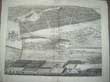
(Code No. 4075)
Panorama of the River Thames,
Eton to Nore, In 1849.
(Antique Print).
London. William Little, 198, Strand. 26th May 1849. Page size 15 1/4 x 21 1/2 ins. Original wood-engraved Panorama of the River Thames, nicks to blank margins. (modern colouring). Taken from "The Illustrated London News". £130.00
|
Click on picture above to view more images
How to order |
(Code No. 3990)(ANTIQUE MAP).Mogg's Superior Map of LONDON an entirely New Map for 1851, extending from the Thames Tunnel to Hammersmith. Five Shillings.London. W. Mogg. 1851. 8vo, [4 1/2 x 7ins]. Sectional linen backed hand coloured copper engraved map, 34 x 26 1/2 ins , folding to 4 1/2 x 7ins, Original printed slipcase with paper title label , slightly worn with some loss. The Map lists all the roads and principal bulidings.
|
SOLD
|
(Code No. 3828)
Moule, Thomas.
(Antique Map). MIDDLESEX.
London. Virtue. Date 1836 -52. Approx size 270 x 215 mm. Steel engraved coloured (modern colouring) county map of MIDDLESEX. decorated with two vignettes that includes Buckingham Palace and Westminster Bridge. Ornamental border with symbolic figures woven into the design, plus heraldic coat of arms. Moule's county maps are the last series of decorative maps to be published. £45.00
|
Click on picture above to view more images
How to order
|
(Code No. 3465)Harris, John, 1666?-1719. ( Antique Print )."The West Prospect of Knole", Kent, England.London, Printed and sold by D. Midwinter, 1719. Image size 13.5 x 16.5ins. Original copper engraved plate by J. Harris from an original drawing by T. Badeslade. Taken from the History of Kent in five parts by John Harris. Vita Sackville-West English poet and novelist was born 1892 at Knole House in Kent. In 1913 she married the diplomat and journalist Harold Nicholson. Guaranteed to be over 250 years old.
|
SOLD.
|
| (Code No. 3621).
A Descriptive Account of The Guildhall of The City of London: Its History and Associations.
London. Blades, East & Blades. 1886. Folio, [11 1/2 x 15 ins].
Title page (v. blank) + Preface (3) (v. blank) + Contents (v. blank)
+ Plate list + Text 1 to 289 + Corrigenda (v. blank) + 45 Black & white and coloured plates, views, maps, etc, (as listed), slight foxing. Original decorated cloth gilt, part of spine missing. Top edge gilt. |
SOLD |
(Code
No. 3459)
Harris, John, 1666?-1719. (
Antique Print )
"Tutsham
Hall The Seat of Edward Goulston Esq". Kent.
London, Printed and sold
by D. Midwinter, 1719. Image size 13.5 x 16.5ins. Hand coloured
copper engraved print by J. Kip from an original drawing by
T. Badeslade, nicks and creases to edges, no loss. Taken from the
History of Kent in five parts by John Harris. Guaranteed
to be over 250 years old. £90.00 |
Click on picture above to view more images
How to order |
(Code
No. 3440)
Wilkinson, Robert. (Antique Print).
" A Room Built by Sir James Burrows on the Castle Bank at Starburgh near Lingfield Surrey".
London. Robert Wilkinson. Page size 17 x 12 ins. Image size 14 1/2 x 10 1/2 ins. 11th February, 1813. Original copper engraved print by E. Malpas. Slight marks to blank margins. Guaranteed to be over 150 years old. £80.00
|
Click on picture above to view more images
How to order |
(Code
No. 3439)
Nash. J.
"View of Beddington Manor House, Surrey. The Seat of Sir Benjamin Carew".
London. A. Pugin. Page size 18 1/2 x 11 ins. Image size 16 x 8 ins. ca1840. (Private Plate). Hand coloured, (modern colouring), engraved lithographic plate drawn and engraved by Joseph Nash. Guaranteed to be over 150 years old. £80.00
|
Click on picture above to view more images
How to order |
(Code No. 3383)
Norden. John (ANTIQUE MAP).
MIDDLESEX. (Olima Trinoban Tibvs Habitata).
London. 1610 or 1637. Size 285 x 390 mm. Double-page copper engraved
coloured map of MIDDLESEX by William Kip. Ornamental strapwork title
cartouch, separate distance scale.The hundreds with ornamental strapwork.
From the 2nd or 3rd edition of Camden's Britannia, (reverse of map
is blank). Slight foxing, mostly to blank margins. Guaranteed to be
over 350 years old. £200.00 |

Click on picture above to view more images
How
to order
|
(Code No: 2795)Feuille,
Daniel de la.LONDON. "Londres ville Capitalle del' Angleterre fous
le 51 Degre 20 Minutes de Latitude et fous le 19 degre de Longitude"Date.1702-06. Map image size 170 x 114mm. Map size 265 x 185mm.
Copper engraved town plan of London.Taken from
"Atlas Portatif" ..., 1706 (possibly from the earlier Dutch edition of 1702).
Compass rose. Title and coat
of arms cartouche. Neptune and Britannia in a rural setting surrounding
Royal coat of Arms.Very Good Condition.Guaranteed to be over 250 years old.
|
SOLD.
|
(Code No. 3019)Tallis, John. [Antique Map.]:CHANNEL ISLANDS.London. Ca 1850. Size Approx 370 x 260mm. Original
steel engraved map with original outline hand colouring. 4 vignette
views. Decorated border, Centre fold, vg.
|
SOLD.
|
| (Code No. 2637)Collins. Greenville. Capt. (Antique
Sea Chart.) THE
EAST COAST AND THAMES ESTUARY.London. 1693 or later edition. Image
size 22.2 x 17.2 ins. Hand
coloured copper engraved map of East Coast, Thames Estuary and
English
Channel. Compass rose with rhumb lines, sounding, anchorages plus
a coat of arms. Ornamental title (Dedicated to Vice Admiral Ralph
Delaval), cartouche decorated with symbolic figures etc, Separate
scale line. |
SOLD
|
| (Code No. DP
3185)Kitchin, T. (Antique Map.)SURREY. Drawn from an Actual Survey and regulated by Astronomy,
Observed by T. Kitchin.London. Alex. Hogg. 1795. Page size 15 x 9 ins. Image size 8 x
6 1/2 ins. Copper engraved map by T.Kitchin. From Antiquities of
England and Wales by Captain Grose. Guaranteed to be over
200 years old. |
SOLD.
|
(Code No. DP 3186)Kitchin, T. (Antique Map.)SUSSEX. Drawn from an Actual Survey and regulated by Astronomy,
Observed by T. Kitchin.London. Alex. Hogg. 1795. Page size 15 x 9 ins. Image size 9 x
5 1/2 ins. Copper engraved map by T.Kitchin. From Antiquities of
England and Wales by Captain Grose. Guaranteed to be over 200 years
old.
|
SOLD.
|
| (Code No.DP 3188)Kitchin, T. (Antique Map.)SUFFOLK. Drawn from an Actual Survey and regulated by Astronomy,
Observed by T. Kitchin.London. Alex. Hogg. 1795. Page size 15 x 9 ins. Image size 8 x
5 1/2 ins. Copper engraved map by T.Kitchin. From Antiquities of
England and Wales by Captain Grose |
SOLD.
|
| (Code No. DP
3190)Kitchin, T. (Antique Map.)ESSEX. Drawn from an Actual Survey and regulated by Astronomy,
Observed by T. Kitchin.London. Alex. Hogg. 1795. Page size 15 x 9 ins. Image size 8 1/2
x 10 1/2 ins. Copper engraved map by T.Kitchin. From Antiquities
of England and Wales by Captain Grose. |
SOLD
|
(Code No. DP3382)Kitchin, T. (Antique Map.)MIDDLESEX. Drawn from an Actual Survey and regulated by
Astronomy, Observed by T. Kitchin.London. Alex. Hogg. 1795. Page size 15 x 9 ins. Image size 8 1/2
x 10 1/2 ins. Copper engraved map by T.Kitchin. From Antiquities
of England and Wales by Captain Grose. Guaranteed to be
over 200 years old. £50.00
|
SOLD.
|
| (Code No.3208)Kelly's Large folding sectional
Map of ESSEX. London. Kelly Directories. High Holborn. ca1840. Map
size 39 1/2
x 26 ins folding to 9 x 5 1/2 in. Linen backed sectional hand coloured
ordnance survey map for Kelly's Directory. Sold by George Philip & Son, Fleet Street London. Scale bar Approx 1ins to 2mls. 11line
"Explanatory Notes". 7 Line "References to the Hundreds" and compass
indicator. Full morocco gilt, slight rubbing. |
SOLD
|
(Code No. 3229DP)Buck. Samuel and Nathaniel. (Guaranteed Antique Print.):" The North-West Prospect of MAIDSTONE, in the County of Kent"London. 1738,1st edn , (not the later 18th Century or early 19th Century
reprint ). Page size 32 x 31 1/2 ins. This panoramic copper engraving,
of Maidstone is by the most important and best 18th century topographical
artists, the brothers, Samuel and Nathaniel Buck who drew and engraved
a series of panoramas and views of English and Welsh towns, castles
and abbeys etc. They published approx' 420 of the single page engraved
views and by far the most rare and desirable, 83 double page engraved
town panoramas, this being one, showing Coat of Arms, River Medway,
Maidstone's schools, houses, streets, prison, churches etc the text
to base of image, lists with a numbered key, the important locations
plus the town history.(Split to bottom of centre fold, strengthened
on back )
|
SOLD.
|
| (Code No 3230DP) London. March 26th 1739,1st edn, (not the later 18th Century or early
19th Century reprint ). Page size 32 x 31 1/2 ins. This panoramic
copper engraving of Woolwich is by the most important and best 18th
century topographical artists, the brothers, Samuel and Nathaniel
Buck who drew and engraved a series of panoramas and views of English
and Welsh towns, castles and abbeys etc. They published approx' 420
of the single page engraved views and by far the most rare and desirable,
83 double page engraved town panoramas, this being one, showing ships,
Woolwich's landing places, dock-yard and the River Thames etc. The
text to base of image, lists with a numbered key, the important locations
plus the town history.(Split to text area, strengthened on back ) |
SOLD
|
(Code No.3228. DP)Buck. Samuel and Nathaniel. (Guaranteed Antique Print.):" The North-West Prospect of SHEEERNESS, in the County of Kent
".London. March 26th 1739,1st edn, (not the later 18th Century or early
19th Century reprint ). Page size 32 x 31 1/2 ins. This panoramic
copper engraving of Sheerness is by the most important and best 18th
century topographical artists, the brothers, Samuel and Nathaniel
Buck who drew and engraved a series of panoramas and views of English
and Welsh towns, castles and abbeys etc. They published approx' 420
of the single page engraved views and by far the most rare and desirable,
83 double page engraved town panoramas, this being one, showing the
River Medway, ships, the Nore, the Shore House, landing places and
the Minster etc.(Split to bottom of centre fold, strengthened on back
plus a crease to centre fold area.)
|
SOLD.
|
| (Code No. 3170): "The Manor of Winslow with its Members in the County of Bucks" (Buckinghamshire) Court Rolls. General Court Baron Holden. 8 Volumes. Winslow. 1822 to 1829. Page size 8 1/2 x 13 1/2 ins, folding to 4 1/2 x 13 1/2 ins. Approximate 60 numbered hand written pages per year written in a copper plate hand. Listing named Officers, sworn for Winslow, and surrounding areas, Foreman, Setting of named house & land tenancy rates etc. Front cover for year 1829 missing. These manuscript Court Rolls are a unique glimpse into the history of the village of Winslow. |
SOLD |
(Code No. 2702)Buck, Samuel and Nathaniel.(Guaranteed Antique Print).
South Prospect of READING. Berkshire,London. 1734. Page size approx. 860mm x 450mm or 34 x 18 ins. This
panoramic copper engraving of READING is by the most important
and
best 18th century topographical artists, the brothers, Samuel and
Nathaniel Buck who drew and engraved a series of panoramas and
views
of English and Welsh towns, castles and abbeys etc. They published
approx' 420 of the single page engraved views and by far the most
rare and desirable, 83 double page engraved town panoramas, this
being
one, showing ships, The text to base of image, lists with a numbered
key, the important locations plus the town history. Minor splits
to
blank margins.
|
SOLD.
|
Return to top
|
|
..jpg)