SITE CONTENT
Antique Maps & Prints
Britain
Antique Maps - World
Antique Books
Cartographers
Early Prints
Other Stock
|
| Maps, Prints & Books of Africa |
Images |
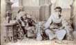
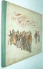
(Code No. 6871)
Anon.
( Antique photograph).
2 North African Berber ladies wearing their traditional dress + hookah pipe.
Date. (c.1860).
Europe. Image size [8 1/2 x 11ins]. Original albumen photograph with 2 printer's creases.
The Berber tribes traditionally weave kilims. The tapestry maintains the traditional appearance and distinctiveness of the region of origin of each tribe, which has in effect its own drawings. The textile of plain weave is represented by a wide variety of stripes, and more rarely by geometrical patterns such as triangles and diamonds. Additional decorations such as sequins or fringes, are typical of Berber weave in Morocco. The nomadic and semi-nomadic lifestyle of the Berbers is very suitable for weaving kilims. The customs and traditions differ from one region to another. ......£170.00 |
Click on picture above to view more images
How to order |
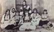
(Code No. 6869)
Anon.
( Antique photograph, laid on to card).
North African Berber gentleman with 6 ladies wearing their traditional dress + child.
Date. (c.1860).
Europe. Image size [6 1/4 x 8ins]. Original albumen photograph.
The Berber tribes traditionally weave kilims. The tapestry maintains the traditional appearance and distinctiveness of the region of origin of each tribe, which has in effect its own drawings. The textile of plain weave is represented by a wide variety of stripes, and more rarely by geometrical patterns such as triangles and diamonds. Additional decorations such as sequins or fringes, are typical of Berber weave in Morocco. The nomadic and semi-nomadic lifestyle of the Berbers is very suitable for weaving kilims. The customs and traditions differ from one region to another. .......£200.00 |
Click on picture above to view more images
How to order |
(Code No. 6731)
Haggard, H. Rider.
SHE.
Date. 1887, 4th edition.
London, Longmans Green, 8vo [5 1/2 x 8ins] Pp. [60], 317, (2) + 2 Plates. Tape marks to front and rear blank fly leafs. Line 22 page 59 "genelemen". Line 26 page 126 "had" should be "have".Original gilt decorated cloth, split hinges with loss to top and bottom of spine. .........£40.00 |
Click on picture above to view more images
How to order |
(Code No. 6652)Bacon. G, A.Bacon's Bold-Feature Map of South & Central Africa.( Bacon's Excelsior).Date. [c.1920].London. G W. Bacon. [Size approx 38 1/4 x 30ins]. Folding to [10 x 13ins] Folding linen backed sectional coloured wall map, showing Map of South & Central Africa. Colour coded explanation in bold feature. Some slight marks. Also showing Principal Railways and Capitals of Countries. Framsteed's Projection.......
|
SOLD.
|
(Code No. 6615)
Edgeworth, Maria.
The Grateful Negro and the Birthday Present.
Date. 1883.
Edinburgh, William P. Nimmo & Co. 12mo, [4 x 6ins]. Coloured frontis. Pp 72, foxing spots & damage to front blank past down. Original decorated cloth, spine faded.
In Jamaica two plantation owners, whose methods of managing their slaves were as different as possible. Mr. Jefferies considered the Negroes as an inferior species, he treated his slaves, or rather suffered his overseer to treat them, with the greatest severity. On the contrary the slave owner Mr. Edwards treated his slaves with far more consideration. He was more understanding and treated them with dignity and kindness.
........
£50.00 |
Click on picture above to view more images
How to order |
(Code No. 6599)
Roome, W.J.W.
Tramping through Africa.
Date. 1930, 1st edn.
London, A & C Black. 8vo, [6 x 9ins]. Pp. xii, 330 + 4pp adverts + 32 Illus.+ Folding map. A dozen crossings of the continent. Brown cloth, slight fading and rubbing on spine......... £35.00 |
Click on picture above to view more images
How to order |
(Code No. 6582)Weller, E.(Antique Map).South Africa.Date.[c.1880].Edinburgh. Blackie & Son.. Page sizes, [22 3/4 x 16ins]. Double page colour printed map. Listing:- Johannesburg, Zululand , Mozambique, Klip River, Namibia, Mozambique, Swaziland, etc, very good condition......
|
SOLD.
|
(Code no. 6555)
Fisher, Ruth B.
On the Borders of Pigmy Land ... [With a preface by Henry Elliott. FOX].
Date. [c.1905, 3rd edn.]
London, Marshall Brothers. 8vo, [6 x 9ins.] No date. Pp. ix, 215 + 32 Photographs, slight marginal foxing. Untrimmed edges. Later editions included a portrait frontis of R. Fisher. Original decorated cloth gilt, very good condition....... £45.00 |
Click on picture above to view more images
How to order |
(Code No. 6550)(Antique Map).Taylor, C.Map of AFRICA.Date. January 1st, 1815.London, Published by C. Taylor. Page size, [10 1/4 x 8 1/2ins]. Original copper engraved map by C.Taylor, slight marks.......
|
SOLD.
|
(Code No.6451)
The Naval History of Great Britain : with the lives of the most illustrious Admirals and Commanders, from the reign of Queen Elizabeth.
Volume 3 only of 4.
Date. 1758.
London, printed for James Rivington and James Fletcher. 8vo, [7 x 5ins]. Copper engraved portrait frontis, pp. xi, 339 + Folding map of Africa by T. Kitchin, split into engraved area. Original quarter calf, split hinges with surface loss..... £60.00 |
Click on picture above to view more images
How to order |
(Code No. 6325)Cole, B.The Port of OPHIR.(2 Antique Maps on one page, Africa and Greece).Date. 1760.London: Stanley Crowder. Page size [8 x 7ins]. Original copper engraved folding map of the The The Ancient way to Tarshish.., very good condition.....
|
SOLD.
|
(Code No. 6296)Wright, A.(Antique Map).AFRICA.Date. 1828.Ebinburgh, Oliver & Boyd. Page size [9 x 7 1/2ins]. Original folding engraved map of the Africa, drawn and engraved by A. Wright, very good condition......
|
SOLD.
|
(Code No. 6276)Moir, Sydney M.Twenty-Four Inches Apart:: The two-foot gauge railways of the Cape of Good Hope.Date. 1981. South Africa, Janus Publishing. 8vo, [8 3/4 x 6ins]. Pp. 182 + Illustrations throughout.Original cloth gilt. Dust Jacket, slight edge nick.At the beginning of the 20th century, 2 ft (610 mm) narrow gauge railway lines started playing a significant role in transporting various agricultural and mineral produce from locations hardly accessible by road. It enabled many communities to become prosperous.These lines featured the largest and most powerful locomotives ever in existence on two foot gauge railways worldwide.
A Spoornet Class 91-000 on the Avontuur Railway near Humansdorp. All two foot railways were operated isolated from each other. However, this did not prevent standardization and interchangeability of rolling stock and locomotives.....
|
SOLD.
|
(Code No. 6203)Marsh, John H.SKELETON COAST.Date. Nov, 1944.London, Hodder, 8vo, [6 x 8 1/2ins]. Pp. viii, 124 + Illustrations. Original cloth. No dust jacket.The story of the wrecking of the big British passenger liner Dunedin Star and the eventual rescue of her more than 100 passengers and crew, at the cost of other lives, another ship, a big aircraft, a number of army trucks, etc., has become known to millions since the book was first published, and is generally accepted to be the peer of true adventure stories so far to come out of Africa......
|
SOLD.
|
(Code No. 6071)Kitchin, Thomas.(Antique Map).AFRICA.Date. 1763.London, London Magazine. Page size (10 1/2 x 8 1/4ins]. Original copper engraved folding map, slight split into engraved area.Thomas Kitchin, (1719-1784) was an English engraver and cartographer. He was born in Southwark, and was apprenticed to Emanuel Bowen in 1732. Originally based in Clerkenwell, by late 1755 Kitchin was established on Holborn Hill. From 1773 Kitchin was appointed royal Hydrographer to the king. .......
|
SOLD.
|
(Code No. 6054)SANSON. Nicholas .(ANTIQUE MAP).BARBARY COAST.(Title - Partie de Barbarie en est Royaume de ALGER divise' en fer Provinces Part du Biledulgerid, ou font Tegorarin, Zeb, &c . Par N, Sanson d' Abbeville Geogr' or dre du Roy).Date. [c.1650].Paris. Size 320 x 220 mm. Copper engraved map with elaborate title cartouch with gradations of latitude and longitude in inner border.Nicolas Sanson (1600–1667) was a French cartographer, wrongly termed by some the creator of French geography. He was born of an old Picardy family of Scottish descent, at Abbeville, on the 20th (or 31st) of December 1600. Guaranteed to be over 340 years old.........
|
SOLD.
|
(Code No. 5991)South African Railways.Illustrated Catalogue.Date. 1928.Berlin, L. Schwartzkoff, Folio, [8 1/2 x 13ins].Pp.28. + 27 Full page illustrations of Catalogue of Details of Class 19 4-8-2 Type Engines with Bogie Tender. Nos.1366-1369. Original cloth gilt, slight marks.......
|
SOLD.
|
(Code No. 5990)South African Railways.Illustrated Catalogue.Date. 1928.Hannover, Hanomag. Folio, [8 1/2 x 13ins]. Pp.28. + 28 Full page illustrations of Catalogue of Details of NG/G Class 2-6-2 2-6-6 Type "Garratt" Engines Nos. 77 to 83 Inclusive. Fitted with "M & L" Superheaters. Original cloth gilt. slight marks....
|
SOLD.
|
(Code No. 5948)The Life and Explorations of David Livingstone.Date. 1887.London, Walter Scott. 4to. Pp viii, 632, slight marks, mostly to margins + Coloured frontis + Coloured engraved title page + 10 Coloured plates, (chromolithographs). Original pictorial cloth gilt, rubbed and faded. Top edge gilt. Tight copy.....
|
SOLD.
|
(Code No. 5947)
GILLMORE, Parker.
Days and Nights by the Desert.
Date. 1888 1st edn.
London. Kegan Paul, Trench & Co. Medium 8vo, [ 9 x 6 ins ]. Pp viii,+ 234 text + 32 adverts + Engraved frontis + 12 Full page and many text illustrations, vg. Original gilt-decorated cloth, slight rubbing and slight mark to back cover.
Parker Gillmore was a Scottish seasoned world traveller, big game hunter and later a soldier, who arrived in South Africa in 1875. He served as a captain in the British Army during the Crimean War and had wide shooting experience in North America, India, China and Africa. He was also prolific author, writing about his journeys that had taken him to dangerous parts of North America and Africa. On occasion, Parker Gillmore used the pen-name 'Ubique'........ £70.00 |
Click on picture above to view more images
How to order |
(Code No. 5677)Stanley, Henry M. (Henry Morton), 1841-1904.Stanley and Africa: also, the travels, adventures, and discoveries of Captain John H. Speke, Captain Richard F. Burton ... and other distinguished explorers.Date. [c.1890].London. Walter Scott. 4to, [275 x 220 mm]. Pp vii. 662. Lacks front fly leaf and some slight marks. 12 Chromolithograph plates. Original decorated red cloth gilt, faded and rubbed at top and bottom of spine. Gilt edges......
|
SOLD.
|
(Code No. 5514)Theal, George M'Call.South Africa. The Cape Colony, Natal, Orange Free State, South African Republic, Rhodesia, and All Other Territories South of the Zambesi.Date. 1900, 5th edn.London, T. Fisher Unwin. 8vo, [5 1/2 x 8ins]. Pp. xxiii, 452 + Folding map + Illustrations throughout, very good condition. Original half calf gilt, rubbed & faded..
|
SOLD.
|
(Code No. 5351)Fisher, Ruth B.On the Borders of Pigmy Land ... [With a preface by H. E. Fox and illustrations.]Date. [c.1904, 1st edn.] London, Marshall Brothers. 8vo, [6 x 9ins.] No date. Pp.ix, 215 + 32 Photographs, slight foxing. Original decorated cloth gilt, very good. Untrimmed edges. Later editions included a portrait frontis of R. Fisher. Dedication on front free end paper, dated Sept 1905...
|
SOLD.
|
(Code No. 5255)STANLEY, Henry M.How I Found Livingstone. Travels, Adventures and Discoveries in Central Africa; Including four Months' Residence with Dr. Livingstone.Date. 1890.London: Sampson Low, Marston. 8vo,5 x 7 1/2ins. Pp. lxxix, 552 + 19 illustrations + Folding map. Original half morocco. Raised spine bands with gilt-decorated panels, some surface loss and rubbing.Sir Henry Morton Stanley, born John Rowlands (1841 -1904), was a Welsh journalist and explorer and his search for David Livingstone. Stanley is often remembered for the words uttered to Livingstone upon finding him: "Dr. Livingstone, I presume?", although there is some question as to authenticity of this now famous greeting.
|
SOLD.
|
| (Code No. 4975)
Ogilby, John.
(Antique Map.)
St. Helena.
Date. 1670
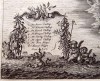
London. Image size 12 x 9 1/2ins. taken from John Ogilby's book Africa, (mostly derived from Cavendish), "being an accurate description of the regions of Ægypt, Barbary, Libya ... with all the adjacent islands ... Collected and translated from the most authentick authors and augmented with later observations, etc". The map portrays the island as square in outline. Locations on the northwest side of the island are keyed to numbers and named in Dutch (bottom left) and English (top right). £150.00
|
Click on picture above to view more images
How to order |
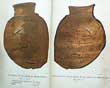
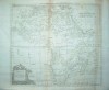
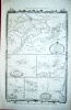
| (Code No. 4883)BELL, James.A System of Geography, Popular and Scientific; or, A Physical, Political, and Statistical Account of the World and its various Divisions.Date. 1840.London: A Fullarton and Co. 8vo, [6 x 9ins.] Volume 3, Part 2. Pp.281-558 + Steel engraved print of "Rome from the Tiber" + 3 Folding maps of Africa, Egypt and South Africa, (Image size 9 x 7 1/2ins), slight foxing Original cloth gilt.
|
SOLD.
|
| (Code No. 4827)
Edwards, Ellis, (Writer on South Africa).
A journey through South Africa .
Date. 1897.
Liverpool: C. Tinling and Co.,( printers). 8vo, [5 1/2 x 7 1/2ins]. Pp. 122 + plates & portraits, slight marks & small hole to margin of one page leaf. Original cloth gilt, faded. Rare copy. £50.00
|
Click on picture above to view more images
How to order |
| (Code No. 4649)Bellin, Jacques-Nicolas (1703-1772).(Antique Map of Madagascar.)Carte de la baye d'Antongil dans l'isle de Madagascar.Date. [c.1764]Paris. Jean Francois de La Harpe, Image size 8 1/2 x 7ins. Page size 8 1/2 x 10ins. Original copper engraved map, very good condition. Taken from "Le Petit Atlas Maritime". Jacques-Nicolas Bellin was a French hydrographer and cartographer. Bellin was born in Paris. In 1721 Bellin was appointed hydrographer (chief cartographer) to the French Navy upon the creation of France's hydrographic office, the Dépôt des cartes et plans de la Marine. Appointed "ingénieur hydrographe" in August 1741. Member of the Académie de Marine and of the Royal Society of London. Over a 50 year career, he produced a large number of maps of particular interest to the Ministère de la Marine. His maps of Canada and of French territories in North America (New France, Acadia, Louisiana) are particularly valuable. He died at Versailles.
|
SOLD. |
| (Code No. 4581)
(Antique Print of the Guinea's Gold Coast. )
Schley. J. van.
VUE SUD OUEST, DE WILLIAMS FORT OU DU FORT GUILLAUME A JUIDA. - Zuidwest-gezigt van de Engelsse sterkte, Williams-Fort, te Whida of Juida.
Date. [c.1820.]
London. (UK watermark). Image size 11x 7 1/2ins. Page size 14 x 10ins. Original copper coloured engraving. £35.00
Fort William in Fida or Ouidah, Benin: 'Three hundred miles of Gold Coast, roughly a hundred trading-post (castles, forts and lesser posts) existed at one time or another, and most of them contemporaneously. Beyond, on the Slave Coast, was the isolated group at Whydah; thence a succession of lagoons and swamps, without a single permanent European station, continued along the remainder of West Africa' (Lawrence, Trade castles & forts of West Africa, p.42).
|
Click on picture above to view more images
How to order
|
| (Code No. 4580)
Schley. J. V.
(Antique Print of the Guinea's Gold Coast )
Vue Sud Ouest des Forts Anglois et Hollandois de Sukkondi, tirée de Smith.
Date. [c.1820.]
London. (UK watermark). Image size 11x 7 1/2ins. Page size 14 x 10ins. Original copper coloured engraving. View of the British and Dutch forts at Sukkondi, West Africa, seen from the south-west. £35.00
|
Click on picture above to view more images
How to order
|
(Code No. 4579)MALLET, Alain Manesson .1630-1706.(Antique Map of the Attractive view of Chateau de la Mine, Gold Coast.)Chateau de la Mine, (Ghana , West Africa).Date. [c.1683.] Frankfurt, Image size 4 x 6ins. Page size 8 1/4 x 5 1/2ins. Original copper engraved coloured print, very good conditionThis is a view of The Chateau de la Mine, St. George on the Gold Coast, Africa. Allain Manesson Mallet was an eminent mapmaker. He started his career as a foot soldier in the Portuguese army under Louis XIV; he was promoted to the post of sergeant major in artillery division and was made the inspector of fortifications. He subsequently published a number of books on military engineering. His book the "Description de l'Univers" was published in 1683-86, it contained many maps charts and views.
|
SOLD.
|
| (Code No. 4578)MALLET, Alain Manesson .1630-1706.(Antique Map of the Ascension Island.)Isle d'Ascencion.Date. [c.1683.]Frankfurt, Image size 4 x 6ins. Page size 8 1/4 x 5 1/2ins. Original copper engraved coloured print, very good condition. Allain Manesson Mallet was an eminent mapmaker. He started his career as a foot soldier in the Portuguese army under Louis XIV; he was promoted to the post of sergeant major in artillery division and was made the inspector of fortifications. He subsequently published a number of books on military engineering. His book the "Description de l'Univers" was published in 1683-86, it contained many maps charts and views.
|
SOLD.
|
(Code No. 4576)Bellin, Jacques Nicolas. (1703-1772).(Antique Map of the Cape Verde Islands.)Carte des Isles du Cap Verd Dressee sur les Journaux et les Remarques des plus habiles Navigateurs. Par N. Bellin Ingr de la Marine. 1746.Date. [c.1764]Paris. Jean Francois de La Harpe, Image size 11 x 8 1/2ins. Page size 13 x 10ins. Original copper engraved map, very good condition. Taken from "Le Petit Atlas Maritime".Jacques-Nicolas Bellin was a French hydrographer and cartographer. Bellin was born in Paris. In 1721 Bellin was appointed hydrographer (chief cartographer) to the French Navy upon the creation of France's hydrographic office, the Dépôt des cartes et plans de la Marine. Appointed "ingénieur hydrographe" in August 1741. Member of the Académie de Marine and of the Royal Society of London. Over a 50 year career, he produced a large number of maps of particular interest to the Ministère de la Marine. His maps of Canada and of French territories in North America (New France, Acadia, Louisiana) are particularly valuable. He died at Versailles.
|
SOLD
|
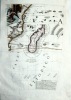
| (Code No. 4571)Bonne, Rigobert. 1727-1794.( Map of South Africa & Madagascar.)Carte du Canal de Mosambique contenant l'isle de Madagascar avec les cotes d'Afrique, depuis le Cap de Bonne Esperance jusqu a Melinde. Par M. Bonne, Ingenr. Hydrographe de la Marine.Date. [c.1780].Geneva. J.L. Pellet. Page sizes, (approx), [14 1/2 x 9 1/2ins.] Copper engraved map. Engraved by Andre, very good condition. Originally published in 1762 in Bonne's "Atlas Maritime".
|
SOLD.
|
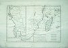
(Code No. 4568)
(Antique Map of South Africa.)
Schley, Van Der & Jacques Nicolas Bellin (1703-1772).
Carte de Toures les Isles connues sur la Coste de Zanguebar et de Madagascar.....
Date. [c.1740].
Paris. Page size 11 1/2 x 10 1/2ins Image size 11 x 9 ins. Original folding hand-coloured map drawn by J. V. Schley. Bellin and Schley worked together to produce an Atlas to accompany "Prevost's Histoire des Voyages, 1738-75". £70.00 |
Click on picture above to view more images
How to order
|
| (Code No. 4547)
Pasha, Rudolf C. Slatin.
Fire and Sword in Sudan. A Personal Narrative of Fighting and Serving the Dervishes 1879-1895.
Date. 1898.
London. Edward Arnold. 8vo, 5 1/2 x 8ins. Pp. xviii, 416, (32, adverts), some foxing spots + 22 Plates + 2 folding maps, split to one fold, no loss. Original cloth gilt, very slight rubbing and faded spine. £35.00.
|
Click on picture above to view more images
How to order
|
| (Code No. 4524)Ruscelli ,Girolamo. Claudio Ptolemy.(Antique map of South Africa.)Africa Nuova Tavola.Date. 1561.Venice. Page size 11 3/4 x 9ins. Image size 7 x 10ins. Original copper engraved map. Taken from La geografia di Claudio Tolomeo Alessandrino, and based on a 1548 edition by Giacomo Gastaldi.An early view of the southern portion of the African continent and the island of Madagascar, (Isola de Lorenzo). Very good condition.
|
SOLD.
|
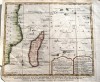
| (Code No. 4519)
CORONELLI, Vincenzo.
(Antique globe gore)
MADAGASCAR, Southeast Africa, Mauritius and the Comoro Islands.
Date. 1688 or later edition.
Venice, Page size 13 1/4 x 19 3/4ins. Image size 10 x 16ins, (approx). For a 42inch globe. Original copper engraved hand coloured map showing a figure symbolizing the source of the Nile. £400.00
Coronelli's maps were based on details which he had produced on globes in 1688. these large globes are very rare, as are the complete set of gores, but separate gores, (this Madagascar map been one of them), do come on the market occasionally. During his career Coronelli produced globes of various sizes, subsequently, issued the gores in book form in 1693. Ref :- Jonathan Potter. Antique Maps.
|
Click on picture above to view more images
How to order
|
| (Code No.4452)
Bonne, Rigobert .1727-1794.
( 4 Maps of various parts of Africa.).
Carte de Canal de Mosambique, Carte du la Haute et de la Basse Guinee, Carte du la Partie Septentrionale D'Afrique, ou de la Barbarie & Partie Occidentale de L' Ancient Continent.....Sierra Leona.
Date. ca1780.
Geneva. J.L. Pellet. Page sizes, (approx), [10 1/2 x 16ins.] 4 Copper engraved maps. Engraved by Andre, slight marks, browning and nick to blank margins. Taken from "Atlas de Toutes les Parties Connues du Globe Terrestre". £70.00
|
Click on picture above to view more images
How to order
|
| (Code No. 4413)
Dixon, Captain Clive. 16th Lancers.
The Leaguer of Ladysmith.
Nov. 2nd 1899 to Feb. 28th 1900.
London, Eyre & Spootiswoode. Oblong 4to.[12 x 9 1/2ins]. 1900. 18 Full page humorous coloured plates drawn over the four months siege of Ladysmith. Bevelled edge boards, slight marks, and stains. £75.00
|
Click on picture above to view more images
How to order
|
| Tallis, John. Africa. London. Ca 1850. Size Approx 330 x 255mm. Original steel engraved map. 5 vignette views, Decorated border, vg. split to fold, repaired on back of map.
|
SOLD.
|
(Code No. 4275)Tallis, John.(Antique Map of South Africa.)Natal and Kaffraria.London. Ca1850. Size Approx 360 x 275mm. Original steel engraved map with original outline hand colouring. Two vignette views that includes Port Natal and Durban. Decorated border. Centre fold.
|
SOLD.
|
| (Code No. 4262)
KITCHIN, Thomas.
Africa Agreeable to the most Approved Maps & Charts.
No date ca1780.
England. Image size [15 x 13 ins.] Original copper engraved map, slight browning to folds and creasing. Taken from Millar's New Complete Universal System of Geography . £80.00
|
Click on picture above to view more images
How to order
|
(Code No. 4125)
Various Charts of Islands &c. in the Atlantic and Pacific Oceans.
London. Alex Hogg. ca1780. Image size 7 1/2 x 12ins, (approx). Page size 15 X 9 1/2 ins, (approx). Copper engraved map of Various Charts of the Islands &c. in the Atlantic and Pacific Oceans. Showing:- The Charts of the Northern Archipelago, discovered by the Russians in the seas of Kamtschatka & Anadir, Azores Isles, Cape Verd Isles, Canary Isles and Madera Isles. Decorated border. Taken from Millar's Geography. Three pages of text describing Cape Verd Isles,. £90.00 |
Click on picture above to view more images
How to order
|
| (Code No. 4072)Tallis, John.Western Africa and Northern Africa.[2 Antique Maps.]London. Ca 1850. Sizes approx 360 x 275mm. 2 Original steel engraved maps with original outline hand colouring. Northern Africa with modern colouring to the vignettes. Decorated borders.
|
SOLD
|
| (Code No. 4070)Tallis, John.Natal and Kaffraria.(Antique Map of South Africa.)London. Ca 1850. Size Approx 360 x 275mm. Original steel engraved map with original outline hand colouring. Two vignette views that includes Port Natal and Durban. Decorated border.
|
SOLD
|
(Code No. 3826).Anon.(Antique Map of Egypt).Aegyptus Antiqua.London. Printed for James Bettenham. 1745. Image size 19 1/4 x 14 1/2 ins. Page size 20 1/4 x 16 ins. Original copper engraved folding map, split to folds, repaired on back.
|
SOLD.
|
| (Code No. 3167).Lodge, John.(Antique Map).AFRICA, from the best Authorities.London. No date, ca1780. Image size 14 x 13 ins. Plate size 16 x 14 ins. Original copper engraved folding map. Guaranteed to be over 200 years old.
|
SOLD
|
(Code No. 3826).Original copper engraved map of south east Africa and Madagascar, 2 nicks into engraved area (approx 1 inch) and foxing spots.
|
SOLD
|
| (Code No. 3808).Macdonald. D.( Antique map of Africa ).Africa " New Sixpenny Maps, Embracing the Most Recent Discoveries"Glasgow. D. Macdonald, 51 Argyll Street. ca1850. Page size 15 x 17 1/2 ins. Image size 14 1/2 x 13 ins. Original steel engraved hand coloured map, slight nicks to blank margins well away from map image.
|
SOLD.
|
(Code No. 3299)
Johnston, Keith. ( 3 Large-Scale Antique Maps of AFRICA )
Royal Atlas of Modern Geography.
London.Edinburgh. Blackwood and Son. ca1860, approx size, 24 x 19
1/2 ins. 4 Hand-coloured in outline double page African maps, (all
loose, no text or covers). Numbers 38, 39 and 40. Engraved and
Printed by W & A.K. Johnston. Showing, North-Western &
Southern Africa, Egypt etc and Abyssinia, vg. £65.00 |

Click on picture above to view more images
How
to order
|
|
(Code
No.3022)Tallis,
John:Africa. (Antique Map )London. Ca 1850. Size Approx 330 x 255mm. Original steel engraved
map. 5 vignette views, one view showing St Helena. Decorated border,
vg. Blank margins cropped to near engraved area.
|
SOLD
|
| (Code
No. 3027)London. ca1850. Size Approx 370 x 260mm. Original steel engraved
map with original outline hand colouring. Four vignette views. Decorated
border. Centre fold, vg.
|
SOLD
|
Return to top
|
|